Die folgende Meldung lässt aufhorchen wie gewaltig das Naturschauspiel gewesen sein muss:
"Although well warned by the Amarillo NWS office, even residents accustomed to weather extremes were stunned by the violence of this storm. One visiting, veteran storm chaser reported citizens frantically running red lights and stop signs in effort to get their vehicles under some form of hail protection."

Eine schöne Hand voll:

Hier wurden gleich reihenweise Autos demoliert:

Man spricht vom "costliest thunderstorm in Panhandle history" (@Klipsi: was gehört zu Panhandle, der gesamte mittlere Westen?)..
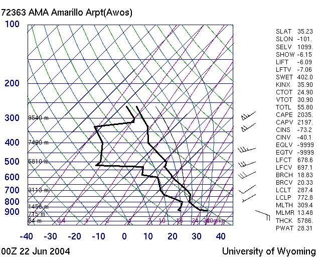
Die Zutaten für dieses Hagelsturm:
"Very unstable air, rich low level moisture, just enough vertical shear, and lift near the intersection of a cold front and outflow boundary combined".. also vor allem viiieeeel CAPE!
http://www.spc.noaa.gov/coolimg/amarillo/sfcmap.gif
Hier das Radarbild mit Hook Echo: http://www.spc.noaa.gov/coolimg/amarillo/ref0047.gif
Und hier der Bericht mit weiteren Bildern: http://www.srh.noaa.gov/ama/html/Jun212 ... /index.htm
SPC Storm Report für diesen Tag: http://www.spc.noaa.gov/climo/reports/040621_rpts.html