Etwas früh für dieses Jahr mit Gewitter, aber wen freuts nicht? Es könnte hier und da am Freitag richtig Abgehen, wenn ich mir die Karte von Estofex so anschaue.
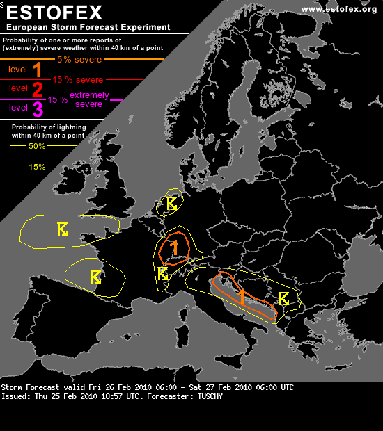
Estofex für Morgen 26. Februar 06:00 UTC:
Forecasting winter time thunderstorms is not always fun, which is the case in the following outlook. From a synoptic perspective, good forcing enters E-France and SW-Germany during the morning hours as an approaching short wave still features a strong cyclonic kink. However, this feature leaves the deep baroclinic zone (placed over central France and Switzerland) and enters a weakly sheared and diffluent coined environment over Germany, so gradual lessening is forecast already during the late morning hours. Further down in the lower troposphere, no real frontal system accompanies the upper vorticity lobe (besides a diffuse cold front). Some wrap around moisture seeps in from the west just behind the cold front, but the best moisture remains north of the area of interest (e.g. Luxembourg and N/central Germany). In addition, LL trajectories feature a long track over the Iberian Peninsula and France, where nocturnal cool down helped to stabilize the eastward moving air mass, so we see no reason for good PBL air mass quality. To summarize all that, we may see some sort of forced line of showers and isolated, embedded thunderstorms over E-France and SW-Germany between 06-12Z. The wind field is strong with 850hPa winds running well above 20m/s, so severe wind gusts will be a good call. A level 1 for severe wind gusts was issued with low lightning probabilities, as not much activity is expected.
Na was wird uns morgen wohl erwarten? Die Analyse ist von TUSHY, nicht so mein Favorit.
Gruss
Dominic
Zuletzt geändert von Severestorms am Fr 26. Feb 2010, 11:00, insgesamt 5-mal geändert.
Grund:Anpassung des Threadtitels
@Moderatoren: Gibts für morgen einen neuen Thread? Oder wird dieser mit dem 25. ergänzt
Aktuell erste Gewitter nördlich von Lyon ... die Spannung steigt
Viele Grüsse
Lukas
@Christian ... da hat es sich ja grad überschnitten ^^
Zuletzt geändert von lukasm am Do 25. Feb 2010, 23:23, insgesamt 1-mal geändert.
Der Donner erschüttert die heitere Bläue des Himmels,
Weil hochfliegende Wolken im Äther einander sich stoßen,
Wenn in der Mitte sie stehn von entgegengerichteten Winden.
aus "De rerum natura", 1. Jh. v. Chr. (Titus Lucretius Carus, Lukrez)
Zwar ohne Blitz und Donner, aber was hier vorhin kurz nach Mitternacht ging, stand einem sommerlichen Gewitterregen wirklich in nichts nach!
Wie hoch liegt eigentlich die Schneefallgrenze? Rein den aktuellen Temps nach geschätzt sicher bei 1800M, das wäre dann deutlich höher als prognostiziert. Aber ja auch kein Wunder bei diesen Luftmassen... Zeit für die Kaltfront!
@meso: Jo danke für den Hinweis, war doch schon etwas zu müde.
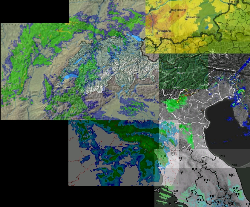
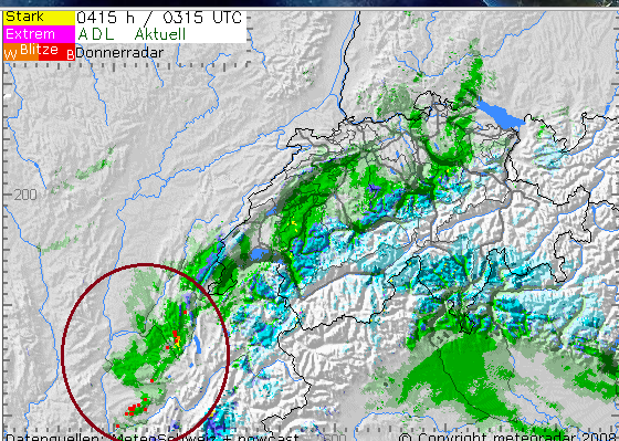
Aktuell hat es massenweise Blitze östlich von Frankreich, nahe an der Schweizer Grenze bei Genf. Mal schauen wie sich das heute noch entwickelt und ob die Zelle uns erreicht bevor sie zerfällt.
lg
Dominic
EDIT: Die Aktuelle Lage scheint so, als ob die Zelle unter der Schweiz hindurch zieht und wir nichts bis nur wenig davon mitbekommen. Vielleicht entwickeln sich noch weitere Gewitter, auf dem Radar ist im Moment nur die eine ersichtlich. ESTOFEX ist gültig ab 06.00 UTC und Level 1 liegt im Norden der Schweiz, die aktuelle Zelle aber ganz im Süden. Vielleicht tut sich noch was, bin auf jedenfall weiterhin gespannt.
Zuletzt geändert von deleted_account am Fr 26. Feb 2010, 05:58, insgesamt 2-mal geändert.
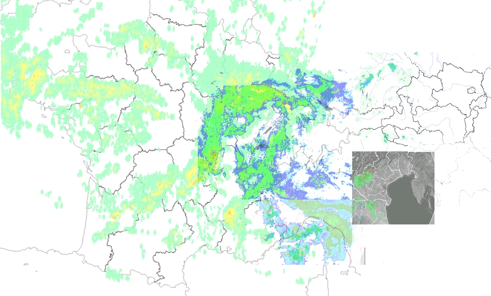
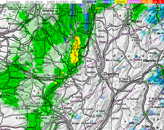
Nachdem es scheint dass die erste Gewitterzelle unter der Schweiz hindurchzieht , lässt IMAPWeather auf eine zweite Zelle, Zugrichtung NO hoffen. Strikes (Blitze) wurden weiter nordwestlich Frankreichs aufgezeichnet.
"Unsere" nahe Zelle (Schwarzer Kreis) und die zweite mögliche Zelle (Roter Kreis). Zugrichtung ist mit feinen schwarzen Linien gekennzeichnet und hoffe mal, dass es so bleibt. Das aktuelle Radarbild / Datenabbild stammt von 05:58 Uhr.
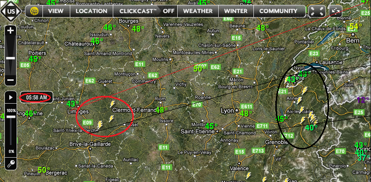
Zum Abgleich, SAT 24 Radarbild:
Gruss
Dominic
Zuletzt geändert von deleted_account am Fr 26. Feb 2010, 06:12, insgesamt 1-mal geändert.
Auf dem Radar ist nichts zu sehen, aber hier sehen wir mehr als sonst!
Wir stehen gerade in Oltingen/Zeltingen auf einem FEldwewg. Richtng Basel Regenfront, richtung Mittelland ist es Blau und klar. Auf der Jurasüdseite geht eine zerfetzte Regenfront durch, auf der Nordseite ebenfalls.
Richtung Südwest / West sind am Horizont Cumuluswolken zu sehen. Darunter bildet sich gerade auch eine Ambossartige Form. Untendran wird es schon mal dunkler. MAl schauen was hier noch kommt.
So, meiner seits würd ich sagen ist nichts mehr mit BLitz und Donner. Kräftige Schauer und Sturmböen sind nach wie vor im Trend. Spreitenbach, aktuell 8.6 Grad, starker Regenfall und Sturmböen 60-70km/h.