Hallo
Da es für heute wohl gelaufen ist kann man ja schon mal einen Blick auf Morgen/Übermorgen wagen...
Ein Kaltlufttropfen über Deutschland dürfte auch die Ostschweiz beeinflussen. NMM 4km hat da vor allem am Sonntag Morgen einiges an konvektivem Niederschlag drin. Die anderen Modelle sind da eher zurückhaltend.
Mein Outlook:
ISSUED: 21.04.2006 18:00 (UTC)
VALID: 22.03.2006 06:00 - 23.03.2006 06:00 (UTC)
SYNOPSIS
--------
Über Mitteleuropa herrscht eine flache Luftdruckverteilung. Für die Schweiz von Bedeutung ist ein Kaltlufttropfen der sich über Deutschland befindet und ab dem Abend die östlichen Landesteile beeinflusst.
Er verursacht ein leichtes Fallen der Höhe in 500hPa und PVA.
Die Winde sind generell schwach mit weniger als 30 Knoten. Sie drehen in der Höhe von West auf Nordwest, unterhalb von 700hPa herrscht Südwestwind vor.
Mit etwas kälteren Temperaturen in der Höhe durch den Kaltlufttropfen ist CAPE im Osten etwas grösser, allerdings kaum über 500 J/kg.
FORECAST
--------
Bis am frühen Nachmittag verläuft der Tag weitgehend Wolkenlos. Dann bilden sich über dem Jura, dem Schwarzwald und an den Voralpen grössere Quellwolken, wobei vor allem im Schwarzwald das eine oder andere Gewitter zu erwarten ist.
Diese Gewitter dürften nur lokalen Charakter haben und kurzlebig sein.
Ab dem Abend steigt das Gewitterrisiko im Schwarzwald durch den Einfluss des Kaltlufttropfens in Deutschland an. Diese Gewitter können dann auch organisierter Auftreten und lokal kräftig ausfallen. In der Nacht auf Sonntag breiten sich diese Gewitter in Richtung Südosten aus und dürften auch die Ostschweiz beeinflussen.
Gruss
Bernhard

Werbung
Gewitter am Wochenende 22.04.2006 / 23.04.2006
-
Bernhard Oker

- Moderator
- Beiträge: 6592
- Registriert: Do 16. Aug 2001, 11:02
- Geschlecht: männlich
- Wohnort: 8902 Urdorf
- Hat sich bedankt: 1941 Mal
- Danksagung erhalten: 3313 Mal
Gewitter am Wochenende 22.04.2006 / 23.04.2006
Bernhard Oker - Urdorf (ZH/CH) - Meine Webseiten "Never Stop Chasing!"
-
Severestorms
- Administrator
- Beiträge: 6651
- Registriert: Mo 20. Aug 2001, 17:21
- Geschlecht: männlich
- Wohnort: Zürich
- Hat sich bedankt: 3801 Mal
- Danksagung erhalten: 1670 Mal
- Kontaktdaten:
Gewitter am Wochenende 22.04.2006 / 23.04.2006
Estofex Outlook für Samstag:
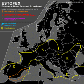
STORM FORECAST
VALID Sat 22 Apr 06:00 - Sun 23 Apr 06:00 2006 (UTC)
ISSUED: 21 Apr 23:17 (UTC)
FORECASTER: DAHL
A threat level 1 is forecast across eastern Spain.
SYNOPSIS
Short-wave trough over the North Sea late Friday evening ... will close off into a small upper cut-off low and stall over NRN Germany on Saturday. Comparatively large upper low over the western portions of the Iberian Peninsula is progged to drop slowly southwards ... thereby enhancing mid/upper ridging over the W Mediterranean. Weak vort maxima will affect the central Mediterranean as well as the S Balkans and Turkey during the period. At the SFC ... quiescent conditions are expected to persist across the central and SRN portions of Europe ... though rather extensive SFC low over the N Maghreb States should strengthen somewhat in response to approaching Iberian upper low ... promoting increasing E/SELY flow over the W Mediterranean and Spain towards the end of the forecast period.
DISCUSSION
...eastern Spain...
TSTMS should re-develop over Spain in weakly unstable/neutral air mass during the early afternoon hours. Though large-scale upward forcing should be limited ... minimal capping should support rather widespread convective development. Deep shear in excess of 30 m/s is expected to exist over eastern Spain ... with increasing low-level shear in the evening and night hours. Also ... it seems that a N Saharan EML will overspread the SW Mediterranean and E Spain in the evening/night hours ... at the nose of which /possibly elevated/ convection should form. Shear profiles should support multicellular storms ... capable of producing marginally severe wind/hail. Late in the period ... increasing LL shear may enhance supercell/tornado threat over E Spain if SFC-based evolution is realized.
...Germany ... W Poland ... Chech Republic...
Scattered TSTMS should persist/re-develop in weakly unstable air mass during midday ahead of small cut-off low along associated weak low-level cold-frontal boundary ... and in weak WAA regime ahead of the front. Mesoscale band of about 15 m/s mid-level winds is expected to exist along the periphery of the upper low ... providing marginal deep shear for organized convection. LL shear is somewhat uncertain as some model-to-model variance exists on the strength of developing SFC low ahead of the upper feature over Germany.
Expect majority of the TSTMS to be non-severe given minimal CAPE and mesoscale nature of marginally favorable deep shear profiles. An isolated marginally severe wind/hail event could occur though ... but coverage is currently anticipated to be too low for a categorical risk. An upgrade may be required if especially the low-level shear turns out to be more ample than currently anticipated so that the threat of mesocyclones increases.
...SE Europe...
Scattered TSTMS should form across portions of SE Europe with diurnal heating ... augmented by weak DCVA-related ascent which should affect primarily Greece and Turkey. Thermodynamic profiles should be quite weak ... but marginal deep shear of about 20 m/s should be present over southern Greece and southern Turkey. Expect an isolated marginally severe hail/wind event ... but coverage should be below level-one thresholds.
#
http://web0.webbox793.server-home.net/o ... 317sf.html
Founder, Owner and Operator of SSWD - Engaged in Science & Research since 1997.
Follow @SturmarchivCH on Twitter to get accurate information about severe, extreme or unusual weather events in Switzerland - fast and reliable.
Follow @SturmarchivCH on Twitter to get accurate information about severe, extreme or unusual weather events in Switzerland - fast and reliable.
-
Bernhard Oker
- Moderator
- Beiträge: 6592
- Registriert: Do 16. Aug 2001, 11:02
- Geschlecht: männlich
- Wohnort: 8902 Urdorf
- Hat sich bedankt: 1941 Mal
- Danksagung erhalten: 3313 Mal
Gewitter am Wochenende 22.04.2006 / 23.04.2006
Guten Morgen
Der aktuelle LM Lauf hat im Vergleich zu Gestern für den Zeitraum bis Sonntag 00Z mehr Niederschlag drin:
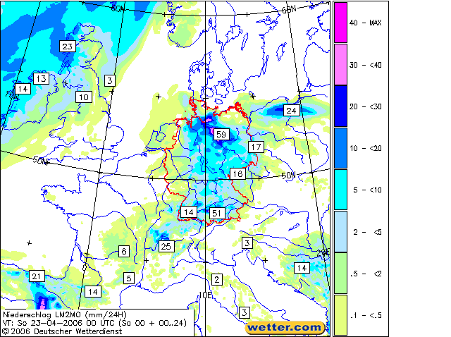
Sonntag 00Z bis Montag 00Z:
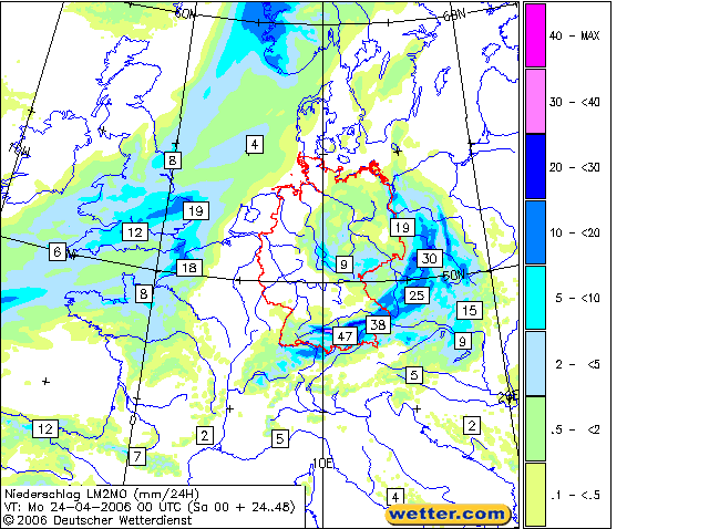
Auch aLMo hat etwas zugelegt, belässt aber die Hauptaktivität in der Nacht auf Sonntag östlich der Schweiz:
Gruss
Bernhard
Der aktuelle LM Lauf hat im Vergleich zu Gestern für den Zeitraum bis Sonntag 00Z mehr Niederschlag drin:
Sonntag 00Z bis Montag 00Z:
Auch aLMo hat etwas zugelegt, belässt aber die Hauptaktivität in der Nacht auf Sonntag östlich der Schweiz:
Gruss
Bernhard
Bernhard Oker - Urdorf (ZH/CH) - Meine Webseiten "Never Stop Chasing!"
-
Alfred

- Beiträge: 10469
- Registriert: Mo 21. Jul 2003, 16:23
- Geschlecht: männlich
- Wohnort: 8037 Zürich
- Hat sich bedankt: 49 Mal
- Danksagung erhalten: 90 Mal
Gewitter am Wochenende 22.04.2006 / 23.04.2006
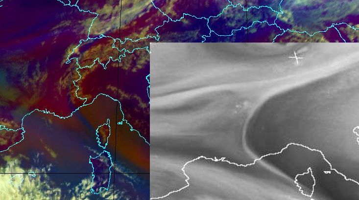
Sali zäme
Haben wir genügend Feuchte für auch etwas Gewitter im Mittelland?
Könnte ein Grenzfall werden. Wasserdampfbild von 06 UTC:
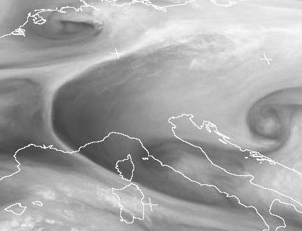
Und die Luftmassebewegung über Zürich um 00Z, 36 Std. zurück und 36 Std. vorwärts, 925 bis 700 hPa.
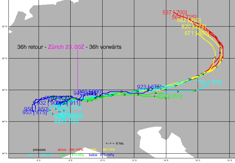
Grüsse, Alfred
[hr]
Haben wir genügend Feuchte für auch etwas Gewitter im Mittelland?
Könnte ein Grenzfall werden. Wasserdampfbild von 06 UTC:
Und die Luftmassebewegung über Zürich um 00Z, 36 Std. zurück und 36 Std. vorwärts, 925 bis 700 hPa.
Grüsse, Alfred
[hr]
-
Bernhard Oker
- Moderator
- Beiträge: 6592
- Registriert: Do 16. Aug 2001, 11:02
- Geschlecht: männlich
- Wohnort: 8902 Urdorf
- Hat sich bedankt: 1941 Mal
- Danksagung erhalten: 3313 Mal
Gewitter am Wochenende 22.04.2006 / 23.04.2006
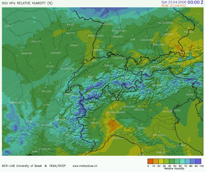
Hallo Alfred
Die RH900 schaut nicht gerade gut aus nach NMM:
http://www.sturmforum.ch/forum_uploads/ ... 110653.jpg
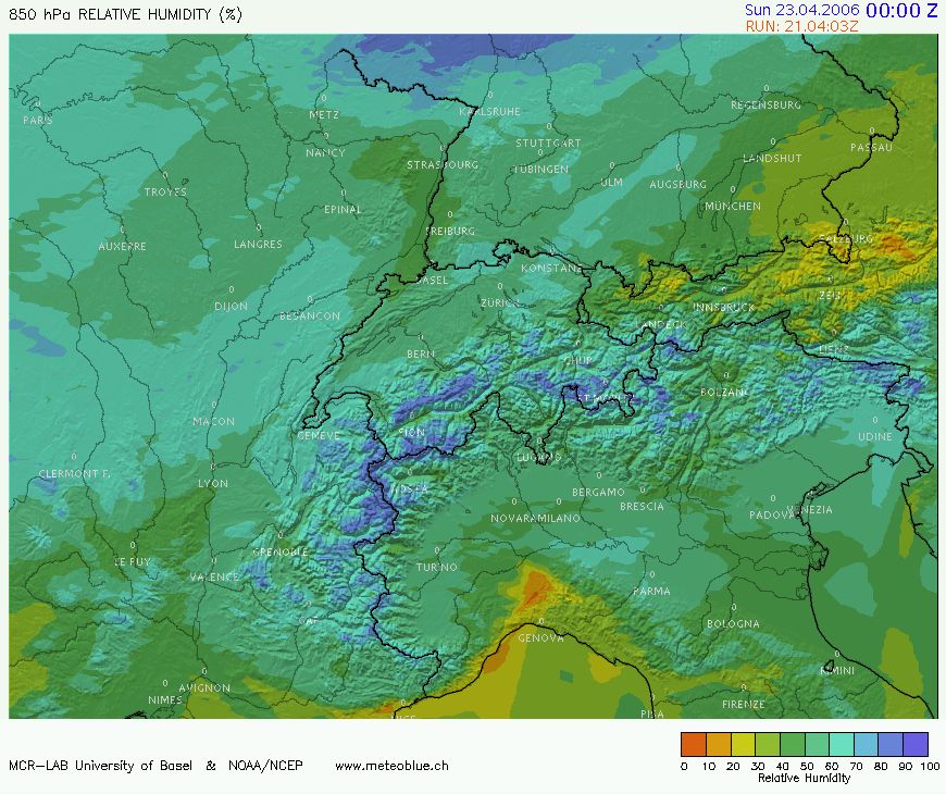
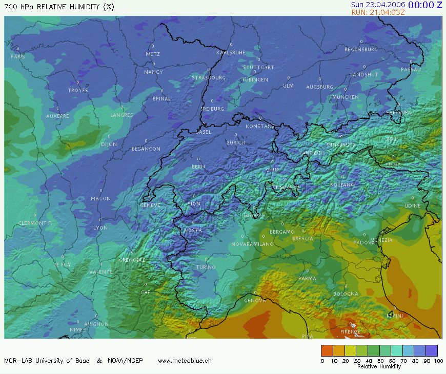
Allerdings in 850 und 700 sieht es besser aus.
http://www.sturmforum.ch/forum_uploads/ ... 110757.jpg
http://www.sturmforum.ch/forum_uploads/ ... 110814.jpg
Könnte für etwas Elevated Convection reichen...
Gruss
Bernhard
Die RH900 schaut nicht gerade gut aus nach NMM:
http://www.sturmforum.ch/forum_uploads/ ... 110653.jpg
Allerdings in 850 und 700 sieht es besser aus.
http://www.sturmforum.ch/forum_uploads/ ... 110757.jpg
http://www.sturmforum.ch/forum_uploads/ ... 110814.jpg
Könnte für etwas Elevated Convection reichen...
Gruss
Bernhard
Bernhard Oker - Urdorf (ZH/CH) - Meine Webseiten "Never Stop Chasing!"
-
Bernhard Oker
- Moderator
- Beiträge: 6592
- Registriert: Do 16. Aug 2001, 11:02
- Geschlecht: männlich
- Wohnort: 8902 Urdorf
- Hat sich bedankt: 1941 Mal
- Danksagung erhalten: 3313 Mal
Gewitter am Wochenende 22.04.2006 / 23.04.2006
Aktuelle Payerne Sondierung berechnet aus den ANETZ Werten für 10Z und der Payerne Sondierung für 00Z:
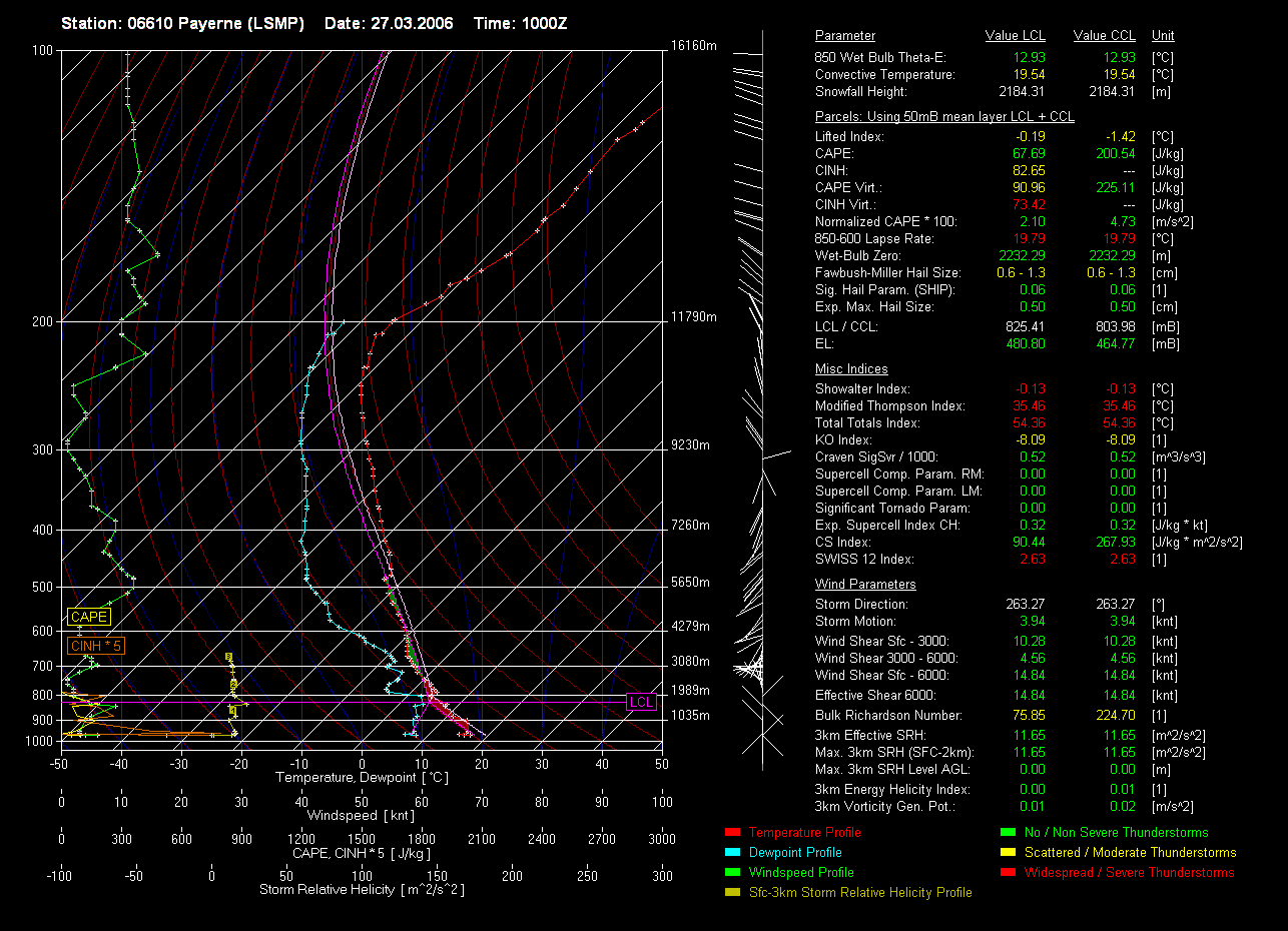
Erster CB am westlichen Jura (nach rechts scrollen -->):

Gruss
Bernhard
- Editiert von Bernhard Oker am 22.04.2006, 12:34 -
Erster CB am westlichen Jura (nach rechts scrollen -->):
Gruss
Bernhard
- Editiert von Bernhard Oker am 22.04.2006, 12:34 -
Bernhard Oker - Urdorf (ZH/CH) - Meine Webseiten "Never Stop Chasing!"
-
Peter,Walchwil ZG

- Beiträge: 1665
- Registriert: Fr 10. Mai 2002, 18:03
- Wohnort: 6318 Walchwil 500m ü M
- Kontaktdaten:
Gewitter am Wochenende 22.04.2006 / 23.04.2006
Im Vallée de Joux hat sich bereits eine erste Zelle gebildet.
Grüsse Peter
-
Heiziger

- Beiträge: 1436
- Registriert: Di 18. Jun 2002, 23:30
- Wohnort: 3054 Schüpfen
- Hat sich bedankt: 6 Mal
- Danksagung erhalten: 27 Mal
- Kontaktdaten:
Gewitter am Wochenende 22.04.2006 / 23.04.2006
Hallo zusammen
Am südlichen Ende vom Neuenburgersee braut sich was zusammen.
Könnte hier wohl das erste Gewitter der Saison werden .
.
Greez aus Yvonand
Pat
Am südlichen Ende vom Neuenburgersee braut sich was zusammen.
Könnte hier wohl das erste Gewitter der Saison werden
Greez aus Yvonand
Pat
Wetterstation Schüpfen - Hard: http://www.wetterschuepfen.ch
Wetterstation Camping VD8, Yvonand VD, südlicher Neuenburgersee: http://www.grenouille.ch/Weather
Einmal Gewitter mit viiiel Blitz und Donner bitte


Wetterstation Camping VD8, Yvonand VD, südlicher Neuenburgersee: http://www.grenouille.ch/Weather
Einmal Gewitter mit viiiel Blitz und Donner bitte
-
Alfred
- Beiträge: 10469
- Registriert: Mo 21. Jul 2003, 16:23
- Geschlecht: männlich
- Wohnort: 8037 Zürich
- Hat sich bedankt: 49 Mal
- Danksagung erhalten: 90 Mal
Gewitter am Wochenende 22.04.2006 / 23.04.2006
Sai zäme
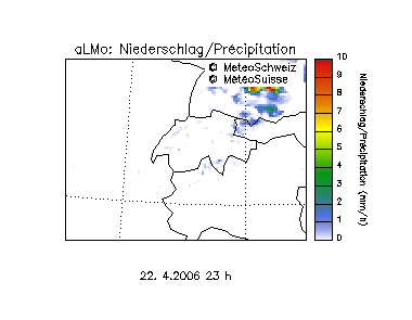
Es könnte reichen, wg. der Feuchte . (12:00 UTC)
(das dukelblaue = feuchte Luft)
Gruss, Alfred
[hr]
Es könnte reichen, wg. der Feuchte
(das dukelblaue = feuchte Luft)
Gruss, Alfred
[hr]