Gruss
Bernhard
In Zusammenarbeit mit meteoradar

Werbung


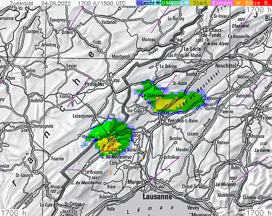
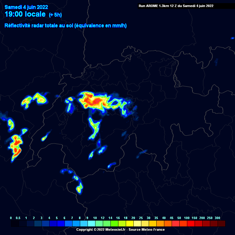
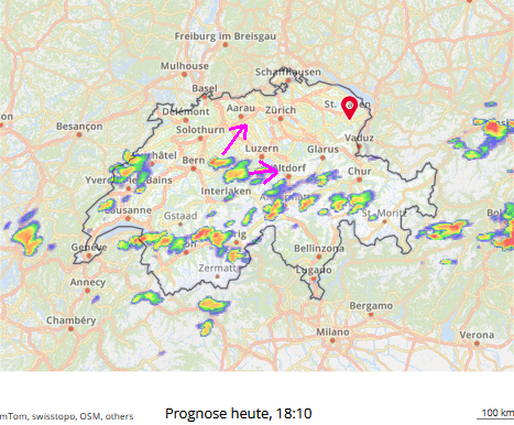
... und Cosmo (search.ch) lässt den Laden runter. Dabei sind einige Faktoren da, welche heute Abend, zumindest im Westen, für Action sprechen:AROME 12Z rechnet heute Abend was grösseres im Mittelland:

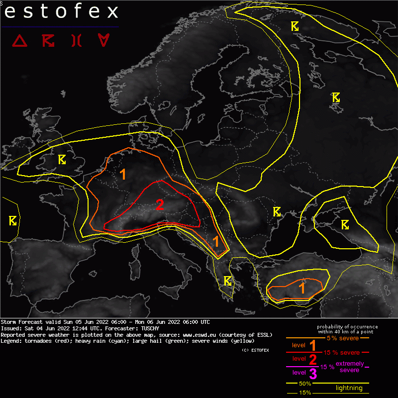
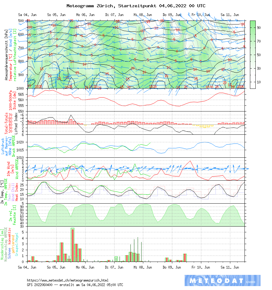
Demnach (und auch von Cosmo gestützt), soll die Hauptaction bei uns vom späten Vormittag an bis zum frühen Nachmittag dauern. Danach könnte der sich möglicherweise über der Schweiz gebildete Gewitterkomplex bereits nach Osten verabschiedet und vorübergehende Subsidenz hinterlassen haben. Könnte, hätte, würde... Sehen wir morgen.Storm Forecast
Valid: Sun 05 Jun 2022 06:00 to Mon 06 Jun 2022 06:00 UTC
Issued: Sat 04 Jun 2022 12:44
Forecaster: TUSCHY
A level 2 was issued across parts of Switzerland, S/SE Germany, Austria, N Italy to Croatia mainly for severe/damaging wind gusts and large to very large hail.
....
DISCUSSION
... Switzerland into S/SE Germany and Austria ...
Main uncertainties with today's setup remain how (probably residual nocturnal) MCS activity behaves over S Germany as activity rolls E along a structuring warm front during the morning hours. Wouldn't be surprised to see this convection entering N Austria before noon or passing on a more northerly track than some models indicate. However it makes sense to build this activity into the CAPE-rich airmass over S Germany and hence we converged to the solution to expect a passing and slowly weakening morning/forenoon MCS passage through parts of the level 2.
Behind that line, temporal clearing should assist in some diabatic heating, which should be enough for CI and worked-over mid-levels (weaker mid-level lapse rates) by latent heat release of the mentioned MCS activity should recover rapidly with EML fanning NE from the Alpine rim.
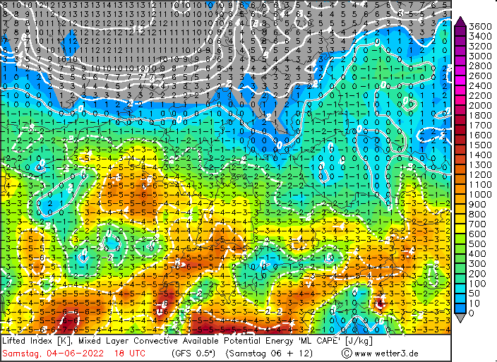
ICON had a good BL moisture handling in the past and hence we still can't deny MLCAPE forecasts of 3 kJ/kg over far SE Bavaria into N Austria but even 1-2 kJ/kg MLCAPE (GFS/IFS) would be enough for long-lived updrafts.
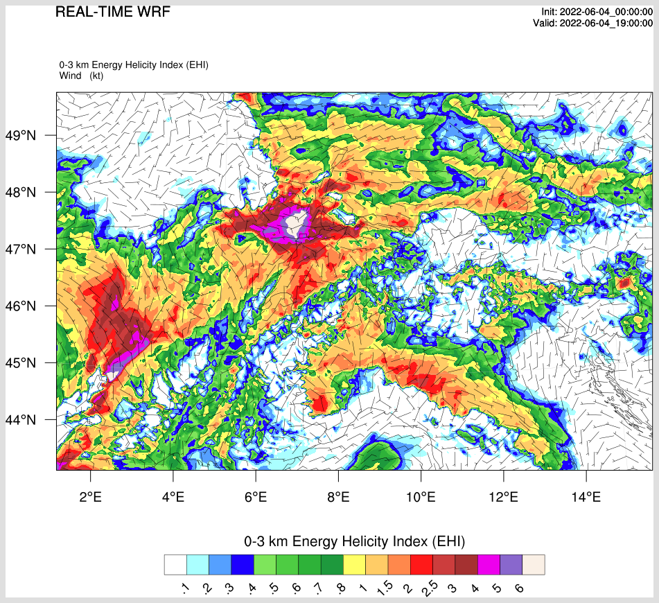
DLS resides in the 15-20 m/s range and area averaged forecast soundings over far SE Germany point to 800-1000 J/kg DCAPE and in excess of 8K/km 0-3km lapse rates.
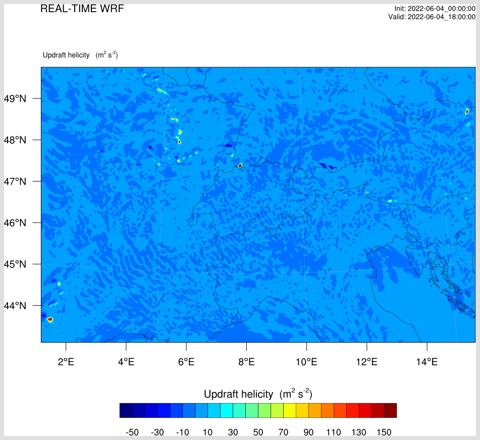
Beyond noon, expect scattered CI from extreme SE France over Switzerland into S/S-CNTRL Germany. A multicell/supercell mixture is forecast with large hail and severe wind gusts the main threat. An isolated very large hail and extreme severe "downburst" gust is possible and initial slow motion could yield locally excessive rainfall amounts.
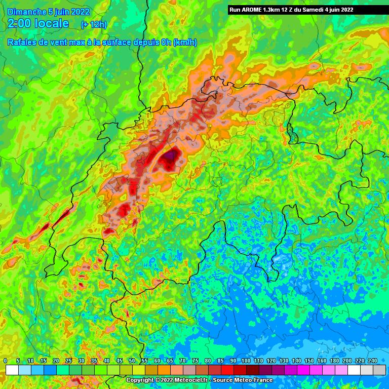
Betimes, rapid upscale growth is anticipated over S Germany, pushed E by strong pressure rise, which emanates E/NE from Switzerland. Models show a developing cold pool with more than 10K cross thermal gradient and given a well mixed LL air mass, swaths of severe/damaging wind gusts with large hail push E towards N Austria and SW Czechia before entering a more stable air mass (especially over Czechia). We broadened up the level 2 over E Austria as there are no real indications for a mature MCS to not race that far E before weakening.
Thought about adding a level 3 area to SE Bavaria into Austria, but lingering uncertainties with morning convection and weak 0-3km shear keep confidence just below this threshold.


Quellgebiet wäre laut Modell die Gegend südlich des Genfersees. Verifikation:Bernhard Oker hat geschrieben: ↑Sa 4. Jun 2022, 17:11 AROME 12Z rechnet heute Abend was grösseres im Mittelland:

Werbung