ICON-D2 rechnet eine Gewitterlinie morgen Nachmittag.
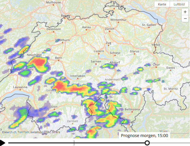
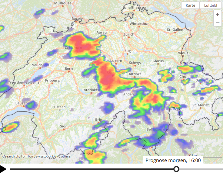
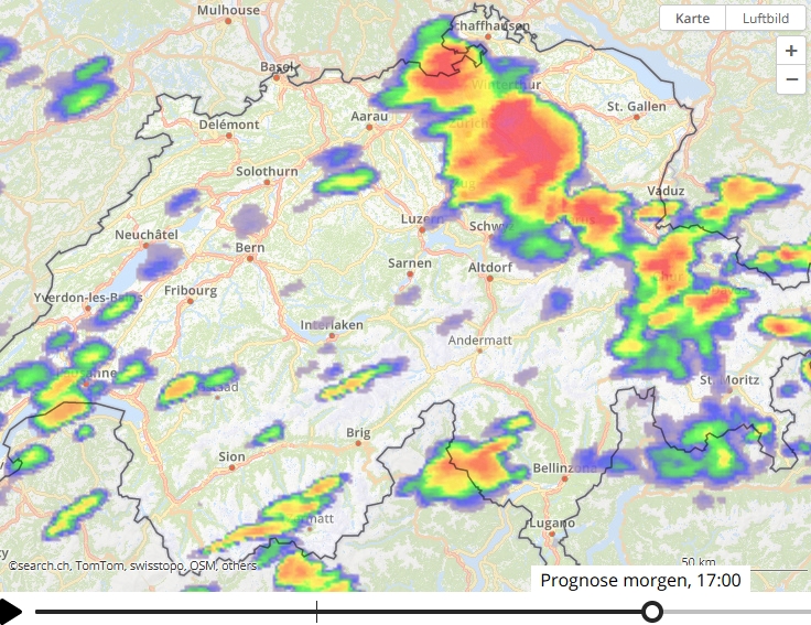
Quelle: https://meteo.search.ch/prognosis
Gruss
In Zusammenarbeit mit meteoradar

Werbung


---
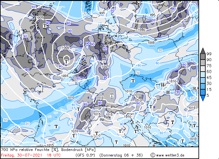
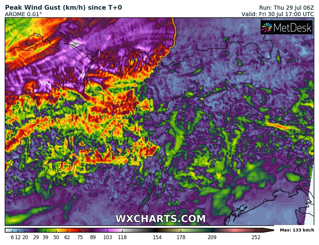
Südlich der Donau ist die Luftmasse auch wieder zunehmend potenziell instabil
geschichtet mit PPW-Werten über 30 mm und gebietsweise mehr als 1000 J/kg
ML-Cape. Vor allem orographisch getriggert, eventuell aber auch unterstützt
durch einen kurzwelligen Troganteil dürften in den Nachmittags- und Abendstunden
dort aus den Alpen heraus bzw. von der Schweiz her Gewitter ins Alpenvorland
ziehen, deren Organisationsgrad wohl aufgrund eher limitierter Scherung (maximal
15 bis 20 m/s DLS nach Lesart des ICON-D2) auf Multizellen bzw. nur kurzlebige
rotierende Aufwindbereiche beschränkt. Gleichwohl ist Unwetterpotenzial in
erster Linie aufgrund von Starkregen und Hagel vorhanden. Insgesamt sind bzgl.
Konvektion SuperHD und auch AROME offensiver aufgestellt als ICON-D2 und
simulieren bereits am späten Nachmittag aus den Alpen heraus Gewitter, ICON-D2
dagegen erst am (späteren) Abend.
...

Wenn's so einfach wäreGoldigoldi hat geschrieben: ↑Fr 30. Jul 2021, 00:08 Was ist denn passiert, das die Modelle nicht gesehen haben?
Darf ich raten: Höhenkaltluft?


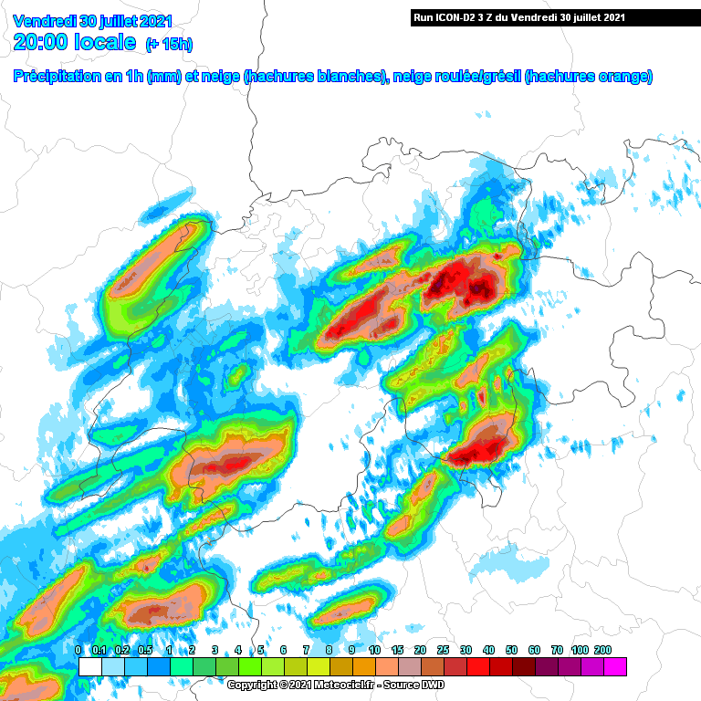

Quelle: estofex.org... belt from central France to Slovakia and Romania ...
A cocktail of a very warm airmass with fairly steep low- to mid-level lapse rates, strong daytime heating, moisture accumulation along the frontal zone and further moisture enhancement by local "recycling" of evaporation once more creates CAPE on the order of 500 to 2000 J/kg. CAPE values increase in general from north to south and from the mountains to the lowlands. This moderately to highly unstable airmass is overspread by moderate deep-layer shear between 15 and 20 m/s underneath the mid-level jet.
Scattered thunderstorms are expected to form from noon onwards over orographic features, in particular the Alps. The forecast model pool somewhat agrees on two rounds of convection in the Alpine region, supported by two subtle short-wave troughs at mid-levels. The first round of storms shall affect the eastern Alps in Austria, Alto Adige / South Tyrol and Slovenia, the second one shall initiate over the Massif Central and the Swiss Alps and shift eastward in the evening. Further mountains looking ready for storm initiation are the High Tatras and the southern Carpathians in central Romania, but without synoptic lift storm coverage will be lower and convection will struggle more to detach from their initiation sites.
The primary convective mode will be multicells and probably several large clusters as the day proceeds. In the belts of suppressed vertical mixing in the upvalley flow regimes, local CAPE and shear enhancement may support some supercells or a few bowing line segments, if storms manage to survive a little distance into the forelands. (Side nide: wind profiles favor right-moving storms on the southern side and left-moving storms on the northern side of the Alps.)
A high coverage of large hail, severe wind and excessive precipitation events is expected that should qualify for a level 2 across a rather wide area in and around the Alps. Isolated extreme events are possible as well (hail with supercells and wind with bowing line segments). The other mountain ranges with less prolific "storm production" mentioned above are covered by level 1 areas.
Storm clusters continue to move eastward well into the night, while they gradually turn elevated and their severe weather risk decreases. In the range of the second trough, residual storms may affect larger parts of SE Germany, the Czech Republic, Austria and Slovenia overnight. Otherwise, capping over flat terrain is very strong and mostly suppresses thunderstorm activity without orographic help, even at peak heating times.
Nichts gegen das Schimpfen, es befreit. Die Sache mit den zu wenigen Radiosonden wie zu Grossvaters Zeiten ist ein Punkt, den ich ohne Übertreibung auch schon seit über 30 Jahren bemängle. Ich kann mir in der digitalisierten Zeit aber auch ein neues, automatisiertes System vorstellen, das diese Sonden alle paar Stunden ausspuckt. Zu beachten wäre ja dann noch die Flugsicherheit, zuviele Ballönli haben die sowohl die zivilen, als auch die militärischen Flugis nicht gern.Federwolke hat geschrieben: ↑Fr 30. Jul 2021, 00:48Das Schimpfen auf die Modelle hat vielleicht doch seine Berechtigung. Man könnte aber auch darüber schimpfen, dass auf dieser Welt für jeden möglichen und unmöglichen Mist genug Geld vorhanden ist, nicht aber für ein dichteres Radiosonden-Netz mit mindestens dreistündlichen Aufstiegen.Goldigoldi hat geschrieben: ↑Fr 30. Jul 2021, 00:08 Was ist denn passiert, das die Modelle nicht gesehen haben?
Darf ich raten: Höhenkaltluft?
Das gibt es ja bereits, sieht so aus:Goldigoldi hat geschrieben: ↑Fr 30. Jul 2021, 09:21 Ich kann mir in der digitalisierten Zeit aber auch ein neues, automatisiertes System vorstellen, das diese Sonden alle paar Stunden ausspuckt.


Werbung