Seite 6 von 7
Re: Flugzeugabsturz über den Atlantischen Ozean
Verfasst: Di 9. Jun 2009, 16:44
von 221057Gino
@Alfred ( Salü )
Von Alfred gepostet
http://www.sturmforum.ch/viewtopic.php?p=105753#p105753
=
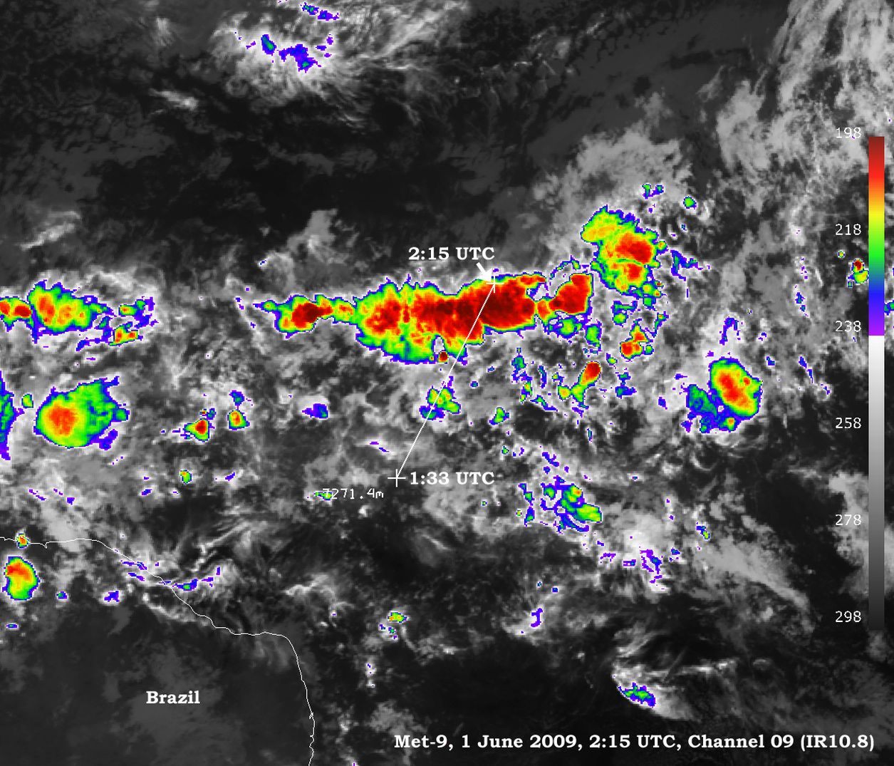
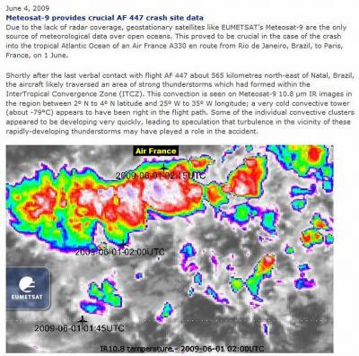
Und hier von EumetSat ( kleiner Bericht )

Re: Flugzeugabsturz über den Atlantischen Ozean
Verfasst: Mi 10. Jun 2009, 15:03
von URBI
+ Von URBI gepostet: Seite 4
Interessant, in der MPE-Animation ist zu sehen, dass der Niederschlag nicht wirklich extremst war.
Die EXE Dateien wurden von mir erstellt und sind sauber.
Grüsse
Re: Flugzeugabsturz über den Atlantischen Ozean
Verfasst: Do 18. Jun 2009, 09:08
von Schnittlauch
Re: Flugzeugabsturz über den Atlantischen Ozean
Verfasst: Do 18. Jun 2009, 09:24
von Alfred
Sali mitenand
Da ich kein Held mit der Internetsucherei bin, kann jemand hier
schreiben, wo die genaue Stelle (Koordinaten) der aufgefundenen
Wrackteile ist?
Gruss, Alfred
Re: Flugzeugabsturz über den Atlantischen Ozean
Verfasst: Do 18. Jun 2009, 16:46
von Schnittlauch
@Alfred
Ich glaube nicht, dass die genauen Koordinaten bisher irgendwo bekanntgegeben wurden.
Ausnahme: Die letzte ACARS-Meldung die den Kabinendruck betraf wurde um 02:14 Uhr UTC an der Position 3° 34′ 40″ N, 30° 22′ 28″ W abgesetzt. (Wikipedia)
Re: Flugzeugabsturz über den Atlantischen Ozean
Verfasst: Mo 22. Jun 2009, 01:53
von HB-EDY
@Alfred
...hier eine Analyse des Fluges AF 447
http://countjustonce.com/af447/
und die ungefäre Position der Wrackteile...
Identified debris has now been recovered from near 3° 34'N, 30° 28'W, or 343°T by 18NM from
3° 16' 28"N 30° 22' 28"W, and with the Atlantic Northern Equatorial Current in this position setting generally NW at between 3 - 6NM per day, though likely to tend more to the north at the onset of the North Equatorial Counter Current, debris will probably be found over a wide area.
salve
Edy
Re: 01.06.2009: AF 447 Absturz über dem atlantischen Ozean
Verfasst: Mi 27. Jan 2010, 13:01
von Severestorms
Zwischenbericht:
In diesem Stadium der Untersuchung und trotz der umfassenden Analysen, die das BEA anhand der
verfügbaren Elemente durchgeführt hat, ist es immer noch nicht möglich, die Ursachen und Umstände
des Unglücks zu verstehen.
Das BEA bestätigt, dass das Phänomen der Inkonsistenz der Geschwindigkeitsmessung eines der Elemente
einer Reihe von Ereignissen war, das zum Unglück geführt hat, es jedoch alleine nicht erklären kann.
Das BEA stellt fest, dass die Fluggesellschaften und Airbus bereits verschiedene Maßnahmen in Bezug
auf die Ausbildung der Besatzungen und den Austausch der Pitot-Sonden der A330/A340 getroffen haben.
Es ist in diesem Stadium jedoch erforderlich, zwei Empfehlungen auszusprechen:
• Die erste stützt sich auf die Arbeiten einer vom BEA initiierten internationalen Arbeitsgruppe, die
auf eine Verbesserung der Effizienz der Ausrüstungen zur Ortung der Flugzeuge und dem Abrufen der
registrierten Daten zur Analyse von Flugzeugabstürzen abzielt, wenn sich diese im Meer ereignen. Ziel ist
es, schneller und sicherer über die Daten zu verfügen, die für das Verständnis des Unglücks erforderlich sind;
• Die zweite Empfehlung zielt darauf ab, die Zusammensetzung der Wolkenmassen in hohen Höhen, in
denen die Langstreckenflugzeuge fliegen, besser zu charakterisieren und Konsequenzen hinsichtlich der
Zertifizierung der Flugzeuge zu ziehen.
und weiter:
Die Flugroute durchquerte die Intertropische Konvergenzzone, die als Zentrum von häufigen Gewittern bekannt ist.
Die meteorologischen Analysen von Météo-France ergänzt durch die Satellitenbeobachtungen der NASA zeigen an, dass
das Flugzeug eine Cumulonimbus-Barriere durchquerte, in denen Turbulenzen herrschten, jedoch ohne Blitze und mit
einer Entwicklung, die nicht als extrem heftig eingestuft werden kann. Nichts lässt darauf schließen, dass es sich um eine
außergewöhnliche Situation handelte.
Quelle:
http://www.bea.aero/en/enquetes/flight. ... ung.de.pdf
im Originalbericht steht u.a.:
Les compléments d’analyse sur la situation météorologique dans la zone de
l’accident, basés sur l’étude des observations ponctuelles prises à 2 h 30 UTC
par le satellite scientifique TRMM (Tropical Rain Measuring Mission), figurent
en annexe 3.
Alors que l’imageur foudre de TRMM indique une absence d’éclair sur la
zone de l’accident à 2 h 30 UTC, l’image infrarouge prise à la même heure
est cohérente avec celles de Meteosat 9 : l’ensemble de ces informations ne
permet pas de conclure à un développement brutal et exceptionnellement
intense de l’activité convective entre 2 h 07 et 2 h 30 UTC.
L’analyse des observations de l’instrument TMI de TRMM, le seul opérant dans
le domaine des micro-ondes, indique la présence d’une forte condensation
autour de 10 000 mètres d’altitude, en dessous de l’altitude des sommets
des cumulonimbus. Cette forte condensation correspondrait à des tours
convectives actives à cette altitude, ce qui confirme la forte probabilité d’une
turbulence marquée au sein de l’amas convectif traversé par la trajectoire
prévue du vol AF447.
Quelle:
http://www.bea.aero/docspa/2009/f-cp090 ... 0601e2.pdf
Weitere Infos:
http://www.bea.aero/fr/enquetes/vol.af. ... af.447.php
Ebenfalls interessant die Anmerkungen des Wetterexperten Tim Vasquez eine Woche nach dem Unglück:
Update / June 9, 2009:
I received an e-mail (see the comments page) from a scientist affiliated with the NASA TRMM mission indicating that no lightning was detected during a 90-second pass of the system that affected Air France Flight 447. This agrees with evidence from the WWLL sferic lightning network for that date. A review of the literature confirms these findings and suggests that convective systems over the equatorial oceanic regions do indeed exhibit an unusual lack of lightning activity. In a 1993 paper E. J. Zipser cites "many examples of intense mesoscale systems, such as squall lines ... extending to 13–17 km in altitude, but that nevertheless produce few reports of lightning. This reinforces the idea, based on data from other tropical ocean regions and from global satellite data, that in spite of the ubiquitous 'hot towers' over tropical oceans, marine cumulonimbus produce little lightning."
Furthermore, a recent paper also published by Zipser (source) underscored the dilution of updraft parcels in the lower portions of equatorial oceanic cumulonimbus clouds while providing an excellent conceptual model for the cloud structure and ice particle distribution that might have affected Air France 447. Though lightning or electrical discharge effects cannot be conclusively ruled out, this set of evidence makes it difficult to offer a coherent explanation predicated on those factors. I have made some adjustments throughout this study to account for the new information.
Update / June 9, 2009:
A reader pointed out Northwest Flight 705, a Boeing 720 which broke up in a Florida thunderstorm in 1963, which has been mentioned in this essay but not yet addressed. So I decided to create proximity soundings based on the Miami radiosonde launch for 1200 UTC and 0000 UTC (crash time was 1930Z). This incorporates a parcel constructed from the T=25C Td=22C conditions observed at Miami and Homestead AFB earlier that morning which is in agreement with the mixed layer parcel moisture value of about 16 g/kg on the Key West sounding. Averaging the two it appears that a CAPE (instability) value of 1670 J/kg occurred with these thunderstorms. It's also noteworthy that the parcel-environment temperature difference, which gives an estimate of updraft severity, was 5 to 7 deg C at FL180-240, which was slightly more than the 4 deg C seen on the AF447 sounding below.
Update / June 9, 2009:
Myself and Scott Bachmeier at University of Wisconsin/Space Science and Engineering Center are requesting that airline pilots who observed a significant warming episode at cruise altitude within the past 10 years and know the exact date/time and approximate location please drop us an e-mail with the story and include your credentials (which will remain anonymous). Unfortunately we must have an exact date and time in order to research the event. I have received a number of anecdotes from pilots who report encountering the phenomena, and while neither of us see evidence yet which supports this occurring in the Air France 447 storm cluster we believe it's a good idea to research this further rather than just dismissing it at this point. We appreciate your help.
Update / June 8, 2009:
It was brought to my attention (thanks Bill S.) that a 1979 episode of sudden upper tropospheric warming has been quantified in the peer-reviewed literature (see here, PDF). Though I had ruled out sudden warming in earlier updates, I had only been considering buoyant cumulonimbus ascent, in which case a 30-degree rise in the cloud would be unprecedented and indeed unsupportable by the theta-e profiles in the air mass feeding the storm, though if it did occur the vertical velocities and turbulence potential would be astronomical.
Though stratospheric "warm sinks" and "cold domes" have been a part of forecasting for years, this paper proposes a very intense, small-scale, convectively driven downdraft mechanism caused by the penetration of a mesoscale convective system into the stratosphere. The paper identifies a scale of about 75 km in width and an anomaly of 18 Celsius degrees. Any forced downward motion from the stratosphere like this will cause very strong adiabatic warming and associated drying, characterized by a profound lack of high cloud layers and low radiance on water vapor imagery (which by a stroke of luck is most sensitive to the upper troposphere). Since a mesoscale signature like this is well within the sampling capability of the GOES and METEOSAT platforms, I immediately reviewed the water vapor loop (SSEC). However it does not appear to show any anomalous subsident signatures. The area to the north of the MCS appears to show normal synoptic-scale subsidence within the trade wind inversion and the A330 is not believed to have made it this far north anyway.
I do have grave doubts a warm, mesoscale subsident area would be enough to significantly disrupt the A330 flight, and occurring in clear air there is a good chance any failure would be recoverable. I will however continue pondering this idea, will work this topic into the study, and will be glad to entertain other thoughts in this direction. The mystery continues.
-- Tim Vasquez
Weather Graphics / Norman, Oklahoma
Quelle:
http://www.weathergraphics.com/tim/af447/
Gruss Chrigi
Re: 01.06.2009: AF 447 Absturz über dem atlantischen Ozean
Verfasst: Do 18. Feb 2010, 12:40
von Severestorms
Meldung: Ab Mitte März sollen zwei Schiffe in einer aufwändigen Suchaktion den Meeresgrund auf einer Fläche von zweitausend Quadratkilometern nach der Black Box absuchen.
Quelle:
http://www.20min.ch/news/kreuz_und_quer ... 7-27537240
Gruss Chrigi
Re: 01.06.2009: AF 447 Absturz über dem atlantischen Ozean
Verfasst: Mo 4. Apr 2011, 12:53
von Severestorms
Hallo zusammen
Ein weiteres Kapitel über den tragischen Flugzeugabsturz vor knapp zwei Jahren wird nun mit dem Fund des Wracks aufgetan:
http://avherald.com/h?article=41a81ef1/0053&opt=0
Es besteht Hoffnung, dass die Datenrecorder gefunden und ausgelesen werden können.
Gruss Chrigi
Re: 01.06.2009: AF 447 Absturz über dem atlantischen Ozean
Verfasst: Do 5. Jul 2012, 15:37
von Severestorms
Vor gut einer Stunde hat das französische
Bureau d'Enquêtes et d'Analyses (BEA) ihr abschliessendes Expertengutachten zum tragischen Flugzeugunglück AF 447 vor drei Jahren vorgestellt. Demnach sei die Crew nach einer Vereisung der Sonden zur Geschwindigkeitsmessung mit der eigentlich beherrschbaren Situation überfordert gewesen. Sie habe im Cockpit der Airbus-Maschine komplett die Kontrolle verloren:
http://www.stern.de/panorama/piloten-wa ... 52150.html
Hier noch eine Animation über die letzten Minuten vor dem Crash:
http://www.20min.ch/ro/videotv/?vid=212942&cid=120
Gruss Chris