Wie in der obigen Grafik ersichtlich, sieht
Estofex über weiten Teilen der Schweiz ein Level 1 Risiko (low coverage of severe weather),
über der Westschweiz sogar ein Level 2 Risiko (high coverage of severe and/or low coverage of extremely severe weather) für Unwetter:
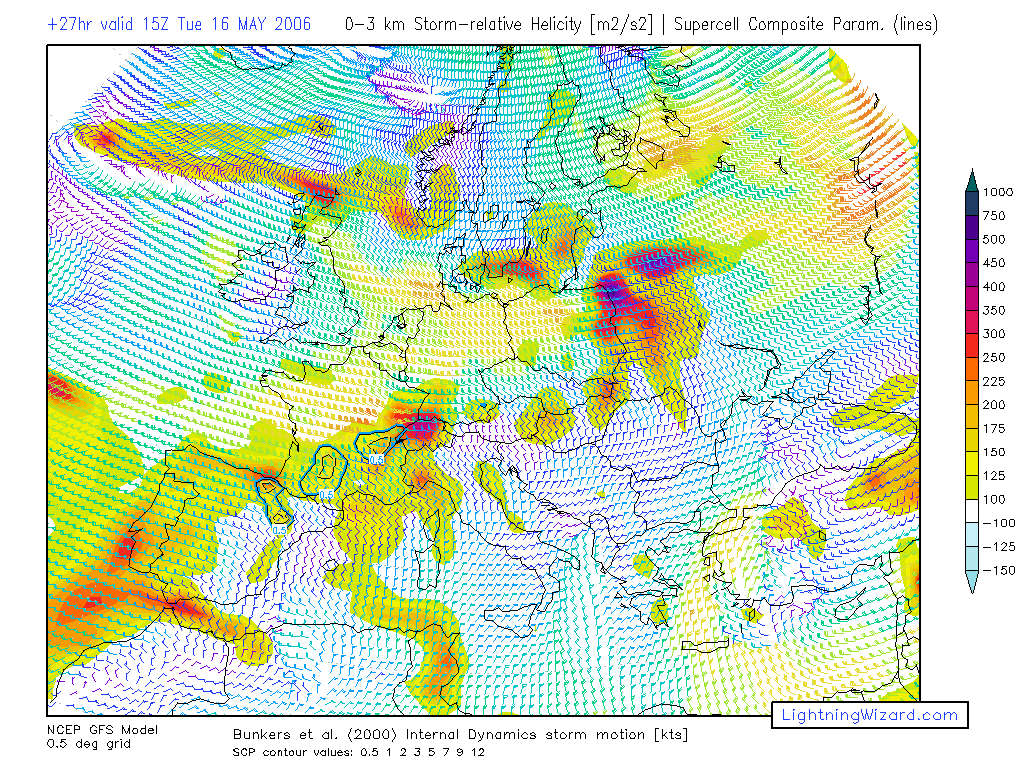
Wenn ich das richtig verstanden resp. übersetzt habe, dann soll sich im Zuge eines sich über Südostfrankreich entwickelnden Kurzwellentroges (in der Folge ein Bodentief) ein ungewöhnlich starker Low Level Jet über dem Jura entwickeln (20 m/s SW auf 850hpa) (siehe auch Hinweise von Bernhard, etc.), welcher zusammen mit moderaten Südwind um die 5 m/s am Boden zu recht guter Geschwindigkeits- und gleichzeitig Richtungsscherung in den unteren Schichten führen wird (bis zu 300 m2/s2 0-3km SRH). Starke Labilisierung durch solares Aufheizen (Restbewölkung von heute Nacht und morgen früh ist noch ein Unsicherheitsfaktor) soll ein (surface based) CAPE von bis zu 1500 J/kg ermöglichen. Aufgrund dieser Bedingungen (v.a. aber wegen der starken Windscherung) sollten Gewitter rasch unwetterartigen Charakter bekommen (grosser Hagel, Sturmwinde, Starkregen). Aufgrund der starken Scherung in den unteren Schichten besteht morgen im Bereich des Juras (evtl. verstärkt durch orographische Effekte) sogar die Gefahr von Tornados (wobei diese unter gewissen Umständen sogar stark ausfallen könnten). Gegen den späteren Abend hin sollen sich die Gewitter dann clustern resp. in einzelnen Bow Echoes enden (hohe Gefahr durch Sturmschäden).
Hier der ganze Outlook in Englisch:
Storm Forecast
Valid: Tue 16 May 2006 06:00 to Wed 17 May 2006 06:00 UTC
Issued: Mon 15 May 2006 21:16
Forecaster: TUSCHY/GROENEMEIJER
SYNOPSIS
Over the Ern Atlantic, an intense upper-level trough continues to shift eastward, placing most parts of Europe under a southwesterly flow. This should set the stage for a possible active severe weather day over parts of France, Switzerland and Germany.
Development will be primarily ahead of a weak upper-level disturbance, which should cross Wrn Europe during the forecast period into central Europe. Another upper level-trough over SE Europe -although much weaker- should help for at least low-end instability release over parts of Bulgaria and Romania, but weak shear should preclude any severe weather threat.
...Central and Ern France, Switzerland, SW Germany...
Around 06:00 UTC, the aforementioned upper-level trough is expected to be located over the Bay of Biscay. Scattered elevated storms are expected to be ongoing in a zone of QG lift ahead of the system over southWrn and central France.
Models differ quite strongly about the timing and intensity of pressure falls ahead of the upper disturbance forming a trough over southern and Ern France that moves eastward during the day and should possibly develop into a surface cyclone tracking eastward over southern Germany early Wednesday morning. The intensity of pressure falls determines the intensity of a southWerly low level jet to develop through the Rhone-Valley and Jura mountains into southern Germany during the afternoon.
We will for now follow the scenario of GFS 12Z that presents a large area of 20 m/s SWly winds at 850 hPa atop 5 m/s Sly surface winds ahead of the surface trough. The resulting strong low-level shear will have a strong impact on the severity of the storms.
In response to solar heating, boundary-layer temperatures should rise to over 25 C south of the system, which with anticipated surface dew points in the 16-18 C range, may allow surface-based CAPE or the order of 1500 J/kg to build. However, insolation may initially be a problem due to residual cloudiness of Monday evenings' convective cluster over Spain.
Surface-based storms are expected to develop across northern parts of the level 2 area and nearby....and may gradually develop further southward down the Rhone Valley. Due to the strong shear and anticipated 300 m2/s2 0-3km SRH storms are likely to become quickly severe, some becoming supercells.
Large hail and damaging winds are likely to occur with the storms, the latter especially when the storms merge into a bow-echo systems that move northEward. Given the presence of strong low-level shear, there will be a chance of tornadoes as well, some of which could be strong.
During the evening and night, bowing convective systems are expected to track through Switzerland into southWrn Germany. As the available instability should be more limited there, they will likely become elevated quite rapidly. If more instability is present over southern Germany than currently expected, storms may make it as far E as Bavaria.
...Wrn France...
In the wake of the trough, clearing is expected to affect Wrn France. Isolation should help to create some instability and scattered storms are expected to develop. Because of teh situation right below a 25-30 m/s jet at 500 hPa, strong deep-layer shear will be present and storms may develop into small bows and perhaps supercells. A threat primarily of some large hail and strong winds should be present.
...United Kingdom and Ireland...
Despite the fact that shear should be very slim over most parts of the highlighted area, conditions will be favorable for scattered thunderstorm development... A slight cool down of the mid-levels and continuing support of a warm and humid airmass in the lower levels should release up to 500 J/kg of CAPE. Maturing storms could locally pose a threat for marginal hail, but allover threat should be rather low.
An area over N-United Kingdom and Scotland will be monitored for thunderstorm development, because shear (0-6 km bulk shear of 15 - 20m/s and slightly enhanced low-level shear) may allow for an isolated large hail threat. Currently expected coverage will be to low for issuing a level 1.
...Southern Germany, Nern Austria and the Czech Republic...
Although conditions look good for organized thunderstorm development, there are still a few uncertainties about the airmass quality. Models like GFS indicate Eward advection of a warm and somewhat humid airmass over most parts of Sern Germany. Remnants of earlier convection and cloudiness due to warm air advection could hinder insolation, but present thinking is that a few hours of insolation will be realized.
Instability should diminish pretty fast during the early night hours, but this negative effect on storm chances/severity could be offset by intense forcing, attached by the Eward moving disturbance. Development of environmental conditions will be monitored. If an upgrade to a level 2 may be issued later.
...NE/E Germany and Poland...
Weakly capped environment and exiting broad low-level through should be conducive
for scattered showers/thunderstorms to develop. 0-6 km bulk shear in the order of 20-25m/s and overlapping instability field will be enough for an enhanced severe wind gust threat.
...Spain...
Subtle rising motion is expected to affect Nern and Ern Spain, where isolated to scattered storms may develop in a moderately sheared environment. Multicells and possibily supercells are expected to develop in an environment of steep low-level lapse rates. Rather steep strong downdrafts may develop as a result and isolated hail will be possible too.
Edit: Peter, du bist mir zuvorgekommen.. ich war noch mit Übersetzen beschäftigt..

Gruss Chrigi
- Editiert von Christian Matthys am 16.05.2006, 00:04 -