Hoi zäme,
Glaube die wissen nicht mehr was sie erzählen sollen (Discussion No.21).
ZETA AS
A WEAKENING CYCLONE SHOULD THEN MOVE BETWEEN THE NORTHWEST AND
NORTH-NORTHWEST UNTIL DISSIPATION. AS YOU CAN SEE...I RAN OUT
THINGS TO SAY.
Gruss Dani (der die Raute Taste auf dem IBook nicht findet)

Werbung
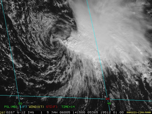
Zeta?
-
Dani (Niederurnen)

- Administrator
- Beiträge: 3993
- Registriert: Fr 31. Aug 2001, 20:39
- Geschlecht: männlich
- Wohnort: 8867 Niederurnen
- Hat sich bedankt: 973 Mal
- Danksagung erhalten: 403 Mal
- Kontaktdaten:
-
Alfred

- Beiträge: 10469
- Registriert: Mo 21. Jul 2003, 16:23
- Geschlecht: männlich
- Wohnort: 8037 Zürich
- Hat sich bedankt: 49 Mal
- Danksagung erhalten: 90 Mal
Zeta?
Sali zäme
ZETA nunmehr eine

000
WTNT35 KNHC 050831
TCPAT5
BULLETIN
TROPICAL DEPRESSION ZETA ADVISORY NUMBER 24
NWS TPC/NATIONAL HURRICANE CENTER MIAMI FL
5 AM AST THU JAN 05 2006
...ZETA WEAKENS TO A TROPICAL DEPRESSION...
AT 5 AM AST...0900Z...THE CENTER OF TROPICAL DEPRESSION ZETA WAS
LOCATED NEAR LATITUDE 22.0 NORTH...LONGITUDE 47.0 WEST OR ABOUT
1075 MILES...1730 KM...EAST-NORTHEAST OF THE NORTHERN LEEWARD
ISLANDS.
THE DEPRESSION IS MOVING TOWARD THE WEST NEAR 12 MPH...19 KM/HR. A
TURN TOWARD THE NORTHWEST IS EXPECTED DURING THE NEXT 24 HOURS.
MAXIMUM SUSTAINED WINDS ARE NEAR 35 MPH... 55 KM/HR...WITH HIGHER
GUSTS. CONTINUED SLOW WEAKENING IS FORECAST DURING THE NEXT 24
HOURS.
ESTIMATED MINIMUM CENTRAL PRESSURE IS 1005 MB...29.68 INCHES.
REPEATING THE 5 AM AST POSITION...22.0 N... 47.0 W. MOVEMENT
TOWARD...WEST NEAR 12 MPH. MAXIMUM SUSTAINED
WINDS... 35 MPH. MINIMUM CENTRAL PRESSURE...1005 MB.
THE NEXT ADVISORY WILL BE ISSUED BY THE NATIONAL
HURRICANE CENTER AT 11 AM AST.
FORECASTER BEVEN
http://www.nhc.noaa.gov/text/refresh/MI ... 0831.shtml
Gruss, Alfred
[hr]
ZETA nunmehr eine
000
WTNT35 KNHC 050831
TCPAT5
BULLETIN
TROPICAL DEPRESSION ZETA ADVISORY NUMBER 24
NWS TPC/NATIONAL HURRICANE CENTER MIAMI FL
5 AM AST THU JAN 05 2006
...ZETA WEAKENS TO A TROPICAL DEPRESSION...
AT 5 AM AST...0900Z...THE CENTER OF TROPICAL DEPRESSION ZETA WAS
LOCATED NEAR LATITUDE 22.0 NORTH...LONGITUDE 47.0 WEST OR ABOUT
1075 MILES...1730 KM...EAST-NORTHEAST OF THE NORTHERN LEEWARD
ISLANDS.
THE DEPRESSION IS MOVING TOWARD THE WEST NEAR 12 MPH...19 KM/HR. A
TURN TOWARD THE NORTHWEST IS EXPECTED DURING THE NEXT 24 HOURS.
MAXIMUM SUSTAINED WINDS ARE NEAR 35 MPH... 55 KM/HR...WITH HIGHER
GUSTS. CONTINUED SLOW WEAKENING IS FORECAST DURING THE NEXT 24
HOURS.
ESTIMATED MINIMUM CENTRAL PRESSURE IS 1005 MB...29.68 INCHES.
REPEATING THE 5 AM AST POSITION...22.0 N... 47.0 W. MOVEMENT
TOWARD...WEST NEAR 12 MPH. MAXIMUM SUSTAINED
WINDS... 35 MPH. MINIMUM CENTRAL PRESSURE...1005 MB.
THE NEXT ADVISORY WILL BE ISSUED BY THE NATIONAL
HURRICANE CENTER AT 11 AM AST.
FORECASTER BEVEN
http://www.nhc.noaa.gov/text/refresh/MI ... 0831.shtml
Gruss, Alfred
[hr]
-
crosley

- Moderator
- Beiträge: 1934
- Registriert: Fr 13. Aug 2004, 15:48
- Geschlecht: männlich
- Wohnort: 5000 Aarau
- Hat sich bedankt: 410 Mal
- Danksagung erhalten: 362 Mal
- Kontaktdaten:
Zeta?
...
uii, neue Konvektion in Zentrumsnähe, vielleicht doch noch ein neuer Anlauf?
Grüsse Crosley
Quelle CNN: Thursday, January 5, 2006; Posted: 10:47 p.m. EST (03:47 GMT)
MIAMI, Florida (AP) -- Tropical Storm Zeta kept its strength Thursday in the eastern Atlantic and could break the record for lasting the longest into January since record keeping began in 1851.
The 27th and final named storm in a tumultuous, record-breaking hurricane season that officially ended more than a month ago, Zeta had sustained winds near 40 mph on Thursday night, according to the National Hurricane Center in Miami.
Zeta's winds had been 35 mph earlier in the day, briefly making the storm just a tropical depression. Zeta posed no threat to land.
Its first incarnation as a tropical storm lasted from December 30 to around 4 a.m. Thursday. The storm was expected to weaken soon because of strong wind shear, hurricane specialist Stacy Stewart said.
"This thing has been very tenacious," he said. "It's probably its last gasp."
Zeta is only the second Atlantic storm in recorded history to survive into January, joining Hurricane Alice in 1955. After Zeta dissipates, Stewart said, forecasters will review records to determine whether it or Alice lasted longest into January.
The 2005 hurricane season officially ended November 30, but hurricane specialist Jack Beven said the season will be considered finished when the last Zeta advisory is issued.
The 2006 season officially begins June 1, but early storms will be part of its tally. The first name on the list is Alberto.
At 10 p.m. EST, Zeta was centered about 990 miles east-northeast of the northern Leeward Islands and moving northwest near 7 mph.
- Editiert von Crosley (Aarau) am 06.01.2006, 07:18 -
-
Alfred
- Beiträge: 10469
- Registriert: Mo 21. Jul 2003, 16:23
- Geschlecht: männlich
- Wohnort: 8037 Zürich
- Hat sich bedankt: 49 Mal
- Danksagung erhalten: 90 Mal
Zeta?
Sali zäme
Weil ZETA ja auch bei gewisse Kriterien rekordverdächtig war, der Windbereich, wo
die TS-Stärke erreicht wurde.
Gruss, Alfred
[hr]
Weil ZETA ja auch bei gewisse Kriterien rekordverdächtig war, der Windbereich, wo
die TS-Stärke erreicht wurde.
Gruss, Alfred
[hr]
-
Severestorms
- Administrator
- Beiträge: 6648
- Registriert: Mo 20. Aug 2001, 17:21
- Geschlecht: männlich
- Wohnort: Zürich
- Hat sich bedankt: 3765 Mal
- Danksagung erhalten: 1660 Mal
- Kontaktdaten:
Zeta?
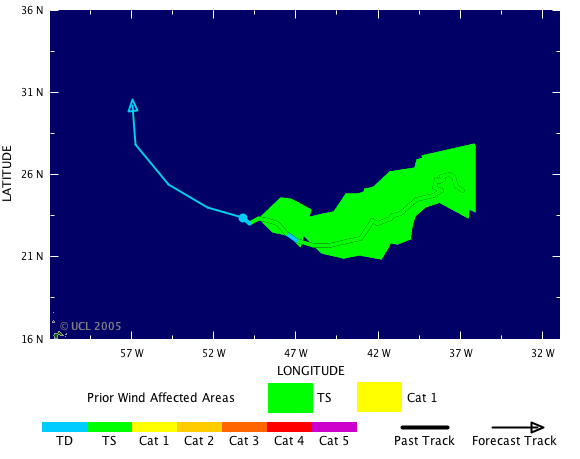
Vielen Dank Alfred!
Habe die Seite noch gar nicht gekannt: http://tsr.mssl.ucl.ac.uk/
Hast du sie bereits während der Saison verwendet? Wie informativ und aktuell war sie?
Gruss Chrigi
Habe die Seite noch gar nicht gekannt: http://tsr.mssl.ucl.ac.uk/
Hast du sie bereits während der Saison verwendet? Wie informativ und aktuell war sie?
Gruss Chrigi
Founder, Owner and Operator of SSWD - Engaged in Science & Research since 1997.
Follow @SturmarchivCH on Twitter to get accurate information about severe, extreme or unusual weather events in Switzerland - fast and reliable.
Follow @SturmarchivCH on Twitter to get accurate information about severe, extreme or unusual weather events in Switzerland - fast and reliable.