Bis Freitag/Samstag sind sich die Modelle relativ einig. Ab Sonntag herrscht dann das Motto: Der April macht was er will! Entsprechend haben die Modelle für Sonntag folgende Grosswetterlagen im Angebot:
West zyklonal (EZ)
West antizyklonal (GFS)
Nordwest antizyklonal Übergang zu Hoch Britische Inseln (GEM)
Hoch Mitteleuropa (NAVGEM)
Nordwest zyklonal (JMA)
West zyklonal Übergang zu Nordwest antizyklonal (CMA, NCMRWF)

Werbung
Blockierte Zirkulation - trockener Frühling 2014?
-
Federwolke

- Moderator
- Beiträge: 8804
- Registriert: Mo 20. Aug 2001, 23:47
- Geschlecht: weiblich
- Wohnort: 3074 Muri bei Bern
- Hat sich bedankt: 1657 Mal
- Danksagung erhalten: 7777 Mal
- Kontaktdaten:
Re: Blockierte Zirkulation - trockener Frühling 2014?
Grüsslis
Fabienne (Muri bei Bern, 560 m)
https://www.fotometeo.ch
https://www.orniwetter.info
https://fotometeo.smugmug.com
https://www.facebook.com/fabienne.muriset
Fabienne (Muri bei Bern, 560 m)
https://www.fotometeo.ch
https://www.orniwetter.info
https://fotometeo.smugmug.com
https://www.facebook.com/fabienne.muriset
-
Uwe/Eschlikon
- Beiträge: 3064
- Registriert: Mi 4. Jun 2003, 14:35
- Wohnort: 8360 Eschlikon/TG
- Danksagung erhalten: 334 Mal
- Kontaktdaten:
Re: Blockierte Zirkulation - trockener Frühling 2014?
Gfs will derzeit, dass es in 1 Woche so ausschaut:
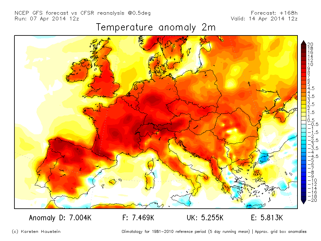
Von einem Extrem ins andere...

Von einem Extrem ins andere...
Zuletzt geändert von Uwe/Eschlikon am Mo 7. Apr 2014, 22:34, insgesamt 1-mal geändert.
Follow me on Instagram: https://www.instagram.com/natur_schweiz/
-
Federwolke
- Moderator
- Beiträge: 8804
- Registriert: Mo 20. Aug 2001, 23:47
- Geschlecht: weiblich
- Wohnort: 3074 Muri bei Bern
- Hat sich bedankt: 1657 Mal
- Danksagung erhalten: 7777 Mal
- Kontaktdaten:
Re: Blockierte Zirkulation - trockener Frühling 2014?
Ja, vielleicht sind die Langfristprognosen von Ende März doch besser als die Mittelfristprognosen der letzten Tage...?
Die zyklonalen und somit kühlsten und feuchten Varianten sind aus fast allen Modellen wieder verschwunden. Dass ab Sonntag bis mindestens Mitte nächster Woche Hochdruck dominiert, darüber scheint zumindest zum jetzigen Zeitpunkt Einigkeit zu herrschen. Die Frage ist nur, ob sich das Hoch über den Britischen Inseln oder direkt über uns installiert und damit wie schnell die Zufuhr kühlerer Luft aus Nordwest wieder blockiert wird. Hinten raus tauchen sogar wieder Südlagen auf...
Was schlussendlich daraus wird, erwarte ich mit höchster Spannung. Die Modellwelt hält uns derzeit fast täglich neue Überraschungen bereit.
Grüsslis
Fabienne (Muri bei Bern, 560 m)
https://www.fotometeo.ch
https://www.orniwetter.info
https://fotometeo.smugmug.com
https://www.facebook.com/fabienne.muriset
Fabienne (Muri bei Bern, 560 m)
https://www.fotometeo.ch
https://www.orniwetter.info
https://fotometeo.smugmug.com
https://www.facebook.com/fabienne.muriset
-
Willi
- Administrator
- Beiträge: 8929
- Registriert: Fr 10. Aug 2001, 16:16
- Wohnort: 8143 Sellenbüren
- Hat sich bedankt: 4066 Mal
- Danksagung erhalten: 3966 Mal
- Kontaktdaten:
Re: Blockierte Zirkulation - trockener Frühling 2014?
Das wär doch eine Saftlage  . Reine Spekulation mit open options in alle Richtungen, aber etwas Träumen gehört auch dazu, oder nicht?
Gruss Willi
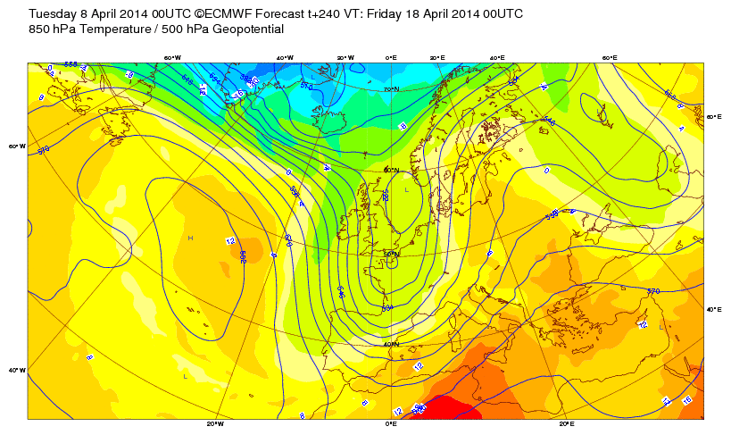
Quelle: ecmwf.int
Gruss Willi
Quelle: ecmwf.int
Gruss Willi
Immer da wenn's wettert
Immer da wenn's wettert
-
Federwolke
- Moderator
- Beiträge: 8804
- Registriert: Mo 20. Aug 2001, 23:47
- Geschlecht: weiblich
- Wohnort: 3074 Muri bei Bern
- Hat sich bedankt: 1657 Mal
- Danksagung erhalten: 7777 Mal
- Kontaktdaten:
Re: Blockierte Zirkulation - trockener Frühling 2014?
Ui Willi, sag das mit dem Träumen besser nicht zu laut  Für das normal arbeitende Volk wäre das der Alptraum: Wochenlang Sonnenschein und Wärme und dann genau auf die Ostertage der Chlapf! Mir persönlich kann's recht sein, Feiertage sind die besten Büro-Tage. Alle anderen kann ich beruhigen: Das ist tiefster Spekulations-Glaskugel-Purzelbaum-Modell-Bereich. Selbst die vermeintliche Einigkeit der gestrigen Abendläufe für Anfang nächster Woche ist ja heute bereits wieder am wackeln...
Grüsslis
Fabienne (Muri bei Bern, 560 m)
https://www.fotometeo.ch
https://www.orniwetter.info
https://fotometeo.smugmug.com
https://www.facebook.com/fabienne.muriset
Fabienne (Muri bei Bern, 560 m)
https://www.fotometeo.ch
https://www.orniwetter.info
https://fotometeo.smugmug.com
https://www.facebook.com/fabienne.muriset
-
Alfred

- Beiträge: 10469
- Registriert: Mo 21. Jul 2003, 16:23
- Geschlecht: männlich
- Wohnort: 8037 Zürich
- Hat sich bedankt: 49 Mal
- Danksagung erhalten: 90 Mal
Re: Blockierte Zirkulation - trockener Frühling 2014?
Sali zäme
Es ist auch nach dem ECMWF noch alles möglich!
Zum Beispiel die 850 hPa ENS´i Temperatur für den 18. 00Z von Zürich +10°C / -7°C (aus allen 50 Members).
Bis 72 h vorwärts geht es ja noch, aber ab 168 h ist einfach alles, ohne irgendwelche Schwerpunkte verteilt.
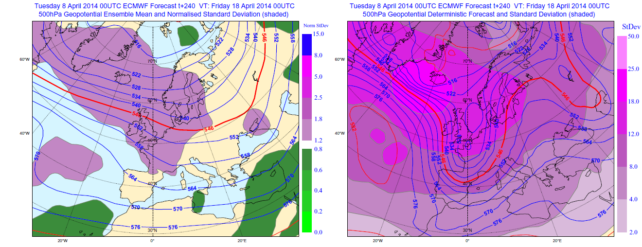
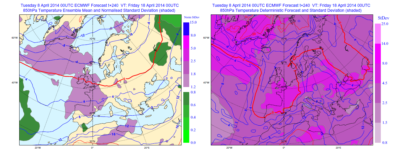
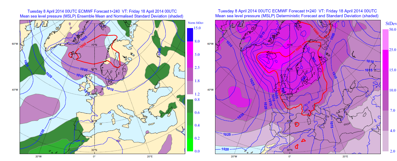
Chart contentsThe four parameters that can be selected for display here are listed below. Contouring in blue and red shows absolute values of these parameters (the meaning of the coloured shading is explained further down):
Pressure reduced to mean sea level (labelled in hPa, 5hPa interval)
Wind speed on the 850-hPa isobaric surface, which is around 1500m above sea level (labelled in m/s, 5m/s interval).
Temperature on the 850hPa isobaric surface, which is around 1500m above sea level (labelled in C, 4C interval).
Height of the 500-hPa isobaric surface, which is around 5.5km above sea level (labelled in dm, 6dm interval).
Note that for 850-hPa wind plots the data resolution used is lower than it is for the other variables - this is to improve legibility.
On the left panels the contours represent the average (mean) of one ensemble - known as the 'ensemble mean'. On the right panels the contours show, for comparison, the single higher resolution 'deterministic' forecast.
The spread within the ensemble is also represented on each panel, using coloured shading. On the right panels spread is simply represented as the standard deviation. The units are the same as in the parameter list above. The left panel, meanwhile, shows the 'normalised standard deviation'; to compute this we take the standard deviation from the right panel and divide it by a 'mean standard deviation'. This 'mean standard deviation' is a pre-computed field, that is a function of lead time and of geographical location. If the initiation time of the selected forecast is 00 UTC it represents the mean of the standard deviations of the 30 most recent 00 UTC ECMWF ensemble forecasts. Similarly for a selected 12UTC forecast the 30 most recent 12 UTC forecasts are used.
So, as an example, if the spread at day 5 in a particular ensemble forecast set (right panel) seems to be large, but has of late also tended to be equally large at day 5 in the same area, then the left panel shading will denote a value that is close to 1 (i.e. no colouring). Conversely if the spread in a particular area at day 5, in one ensemble, exceeds the spread that had recently been seen there at day 5, then the left panel shading will indicate a value rather greater than 1 (purple shading).
InterpretationRelatively large absolute values of standard deviation (right panel shading) tend to indicate relatively high uncertainty in forecasts of the displayed parameter, and thus indicate the extent to which absolute values of the contoured forecast fields (either the ensemble mean on the left panel, or the deterministic forecast on the right panel) can be relied upon. In other words small values on the shaded fields (no colour, or the paler purples) mean high confidence, large values (brighter purples/magentas) mean low confidence.
The normalised standard deviation (left panel shading) aims to put the standard deviation measure into the context of the general ensemble behaviour, in that area, over the last 30 days. So although the forecast for, say, mean sea level pressure on day 8 will ordinarily be a low confidence forecast, there will nonetheless be some occasions when one can be a bit more confident than 'usual', and the normalised standard deviation will tend to show this (by having a value rather less than 1, i.e. green shading).
Quelle Grafik & Hilfstext: ecmwf.int
Gruss, Alfred
Es ist auch nach dem ECMWF noch alles möglich!
Zum Beispiel die 850 hPa ENS´i Temperatur für den 18. 00Z von Zürich +10°C / -7°C (aus allen 50 Members).
Bis 72 h vorwärts geht es ja noch, aber ab 168 h ist einfach alles, ohne irgendwelche Schwerpunkte verteilt.
Chart contentsThe four parameters that can be selected for display here are listed below. Contouring in blue and red shows absolute values of these parameters (the meaning of the coloured shading is explained further down):
Pressure reduced to mean sea level (labelled in hPa, 5hPa interval)
Wind speed on the 850-hPa isobaric surface, which is around 1500m above sea level (labelled in m/s, 5m/s interval).
Temperature on the 850hPa isobaric surface, which is around 1500m above sea level (labelled in C, 4C interval).
Height of the 500-hPa isobaric surface, which is around 5.5km above sea level (labelled in dm, 6dm interval).
Note that for 850-hPa wind plots the data resolution used is lower than it is for the other variables - this is to improve legibility.
On the left panels the contours represent the average (mean) of one ensemble - known as the 'ensemble mean'. On the right panels the contours show, for comparison, the single higher resolution 'deterministic' forecast.
The spread within the ensemble is also represented on each panel, using coloured shading. On the right panels spread is simply represented as the standard deviation. The units are the same as in the parameter list above. The left panel, meanwhile, shows the 'normalised standard deviation'; to compute this we take the standard deviation from the right panel and divide it by a 'mean standard deviation'. This 'mean standard deviation' is a pre-computed field, that is a function of lead time and of geographical location. If the initiation time of the selected forecast is 00 UTC it represents the mean of the standard deviations of the 30 most recent 00 UTC ECMWF ensemble forecasts. Similarly for a selected 12UTC forecast the 30 most recent 12 UTC forecasts are used.
So, as an example, if the spread at day 5 in a particular ensemble forecast set (right panel) seems to be large, but has of late also tended to be equally large at day 5 in the same area, then the left panel shading will denote a value that is close to 1 (i.e. no colouring). Conversely if the spread in a particular area at day 5, in one ensemble, exceeds the spread that had recently been seen there at day 5, then the left panel shading will indicate a value rather greater than 1 (purple shading).
InterpretationRelatively large absolute values of standard deviation (right panel shading) tend to indicate relatively high uncertainty in forecasts of the displayed parameter, and thus indicate the extent to which absolute values of the contoured forecast fields (either the ensemble mean on the left panel, or the deterministic forecast on the right panel) can be relied upon. In other words small values on the shaded fields (no colour, or the paler purples) mean high confidence, large values (brighter purples/magentas) mean low confidence.
The normalised standard deviation (left panel shading) aims to put the standard deviation measure into the context of the general ensemble behaviour, in that area, over the last 30 days. So although the forecast for, say, mean sea level pressure on day 8 will ordinarily be a low confidence forecast, there will nonetheless be some occasions when one can be a bit more confident than 'usual', and the normalised standard deviation will tend to show this (by having a value rather less than 1, i.e. green shading).
Quelle Grafik & Hilfstext: ecmwf.int
Gruss, Alfred
-
Chicken3gg
- Beiträge: 1758
- Registriert: Fr 28. Jun 2013, 21:08
- Geschlecht: männlich
- Wohnort: Allschwil BL
- Hat sich bedankt: 785 Mal
- Danksagung erhalten: 361 Mal
- Kontaktdaten:
Re: Blockierte Zirkulation - trockener Frühling 2014?
möglich ist noch alles, CFS ist sich seiner Sache aber ziemlich sicher - und war die letzten 3-4 Monate glaub jeweils ziemlich korrekt...
April:
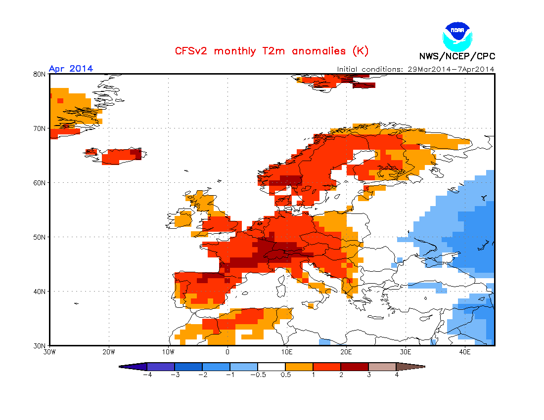
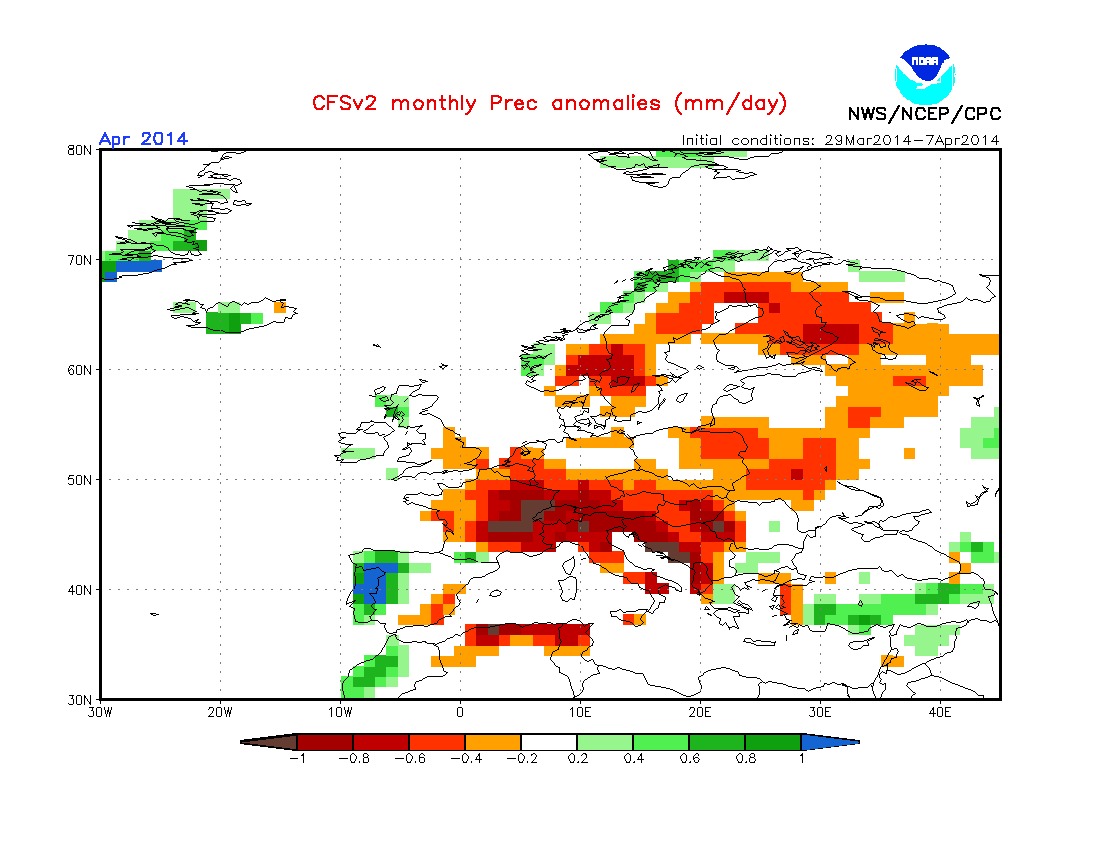
http://www.cpc.ncep.noaa.gov/products/C ... onal.shtml
April:
http://www.cpc.ncep.noaa.gov/products/C ... onal.shtml
Allschwil - http://my.meteoware.com/2714600/
-
An.Di.

- Beiträge: 620
- Registriert: Sa 7. Feb 2004, 23:34
- Wohnort: 79725 Laufenburg Deutschland
- Danksagung erhalten: 12 Mal
- Kontaktdaten:
Re: Blockierte Zirkulation - trockener Frühling 2014?
Mal eine Frage (dachte passt vielleicht am Besten hier rein)... gibt es irgendwo Angaben zur Sonnenscheindauer Winter/Frühjahr? Ich denke, dass die Wärme, aber auch die Sonnenscheindauer zumindest teilweise rekordverdächtig waren, oder täusche ich mich da? Dieses sehr milde, trockene und zumeist sonnige Wetter hält ja schon seit Monaten an...
Grüsse aus Laufenburg
An.Di.
An.Di.
-
Willi
- Administrator
- Beiträge: 8929
- Registriert: Fr 10. Aug 2001, 16:16
- Wohnort: 8143 Sellenbüren
- Hat sich bedankt: 4066 Mal
- Danksagung erhalten: 3966 Mal
- Kontaktdaten:
Re: Blockierte Zirkulation - trockener Frühling 2014?
Hallo An.Di, vielleicht wirst du in diesem Thread fündig:
http://www.sturmforum.ch/viewtopic.php?f=3&t=8997
Gruss Willi
http://www.sturmforum.ch/viewtopic.php?f=3&t=8997
Gruss Willi
Gruss Willi
Immer da wenn's wettert
Immer da wenn's wettert
-
An.Di.
- Beiträge: 620
- Registriert: Sa 7. Feb 2004, 23:34
- Wohnort: 79725 Laufenburg Deutschland
- Danksagung erhalten: 12 Mal
- Kontaktdaten:
Re: Blockierte Zirkulation - trockener Frühling 2014?
Perfekt, Willi... Vielen lieben Dank!
Grüsse aus Laufenburg
An.Di.
An.Di.