

In Zusammenarbeit mit meteoradar

Werbung


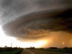
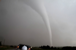
Klipsi hat geschrieben:hallo Freunde,
habe nun eine kleine Selektion meiner besten Tornadobilder von, April, Mai und Juni 2010 aufgeladen , hier :
http://www.klipsi.ch/2010-tornado/tornado2010.htm
fuer naechstes Jahr bieten wir bei Extreme Tornado Tours insgesamt 6 Touren an von jeweils 10 Tagen, ab 22. April. Auf mehreren der Touren wird auch Jim Leonard dabei sein. Die 3 ersten Touren sind ab Oklahoma City, die 3 folgenden Touren ab Denver. Die ETT website ist noch nicht up-to-date fuer 2011 , aber das sollte bald der Fall sein.
irgendwann spaeter werde ich wohl noch ein Potpourri der videoclips auf youtube laden.


Gruss...SYNOPSIS...
A SURFACE LOW CENTERED OVER MN THIS MORNING WILL CONTINUE TO DEEPEN
RAPIDLY AS AN INTENSE NEGATIVE TILT UPPER TROUGH AXIS AND 110 KT
MIDLEVEL JET MAX EJECT NEWD OUT OF THE MID MS VALLEY. AT THE
SURFACE...A STRONG COLD FRONT WILL EXTEND FROM THE MN/WI BORDER SWD
THROUGH CENTRAL IL AND INTO NRN AR AT 12Z...MOVING RAPIDLY EWD
ACROSS THE OH VALLEY TO THE WRN PA BORDER BY 00Z. AHEAD OF THE
FRONT...BROAD SWLY LOW LEVEL FLOW WILL HELP TRANSPORT LOW LEVEL
MOISTURE NWD WITH A 70 KT LOW LEVEL JET.
--- AN OUTBREAK OF SEVERE THUNDERSTORMS WITH WIDESPREAD DAMAGING
WIND AND A FEW STRONG TORNADOES EXPECTED EARLY TODAY ---

Quelle: http://www.courierpress.com/news/2010/o ... a-morning/A severe Thunder Storm Warning was issued at 7:12 a.m. for all or parts of the following counties, including Vanderburgh, Posey and Gibson counties in Indiana; Henderson and Union counties in Kentucky; and White, Wayne, Wabash, Edwards, Saline and Richland counties in Illinois. The warning continues until 7:45 a.m.
The National Weather Service in Paducah, Ky., expects a line of storms with damaging winds to reach Evansville by 7:45 a.m. Wind gusts have reached 55 to 60 mph in some areas.
So far, no tornadoes have been reported with the fast-moving line, but wind damage, including fallen trees and down power lines, have been reported in Jackson, Williamson and Franklin counties in Southern Illinois. That’s about 90 minutes west of Evansville. Schools in Wabash County are on a two-hour delay.
And there was one report of a funnel cloud near Murphysboro in Jackson County, home to Carbondale and Southern Illinois University.
Rick Shanklin, a meteorologist with the weather bureau in Paducah, said while the line of precipitation is 30 to 60 miles wide, the band of stronger winds is only 5 to 10 miles wide.
A tornado watch is in effect for the Tri-State this morning, but the storms will have moved through the region well before that time.
By mid-afternoon temperatures will fall to around 60 and it will remain windy with rain. Some wind gusts could hit 47 mph. Starting Wednesday, sunny conditions will return, with a high of 75 and low of 43.
The Storm Prediction Center has placed much of Indiana in a “high risk” area for severe weather on today, with damaging winds the main concern.
The culprit is an intense low pressure system that is moving through the Plains into the upper Midwest, dragging a strong cold front with it. Most states between the Mississippi River and the Appalachian Mountains are at least partially covered by a wind advisory or a high wind warning, as forecasters expect sustained winds to reach between 25 and 35 mph, with gusts even higher.
A wind advisory is in effect for the region through 3 p.m. today. High-profile vehicles traveling from east to west on roads such as Interstate 64 will be most affected by the winds, the weather service said.
TORNADO WARNING
NATIONAL WEATHER SERVICE PADUCAH KY
722 AM CDT TUE OCT 26 2010
THE NATIONAL WEATHER SERVICE IN PADUCAH HAS ISSUED A
* TORNADO WARNING FOR...
NORTHERN WABASH COUNTY IN SOUTHEAST ILLINOIS...
* UNTIL 745 AM CDT.
* AT 720 AM CDT...NATIONAL WEATHER SERVICE DOPPLER RADAR DETECTED A
SEVERE THUNDERSTORM CAPABLE OF PRODUCING A TORNADO 4 MILES
SOUTHWEST OF LANCASTER...MOVING NORTHEAST AT 60 MPH.
* LOCATIONS IN THE WARNING INCLUDE...
LANCASTER...
PRECAUTIONARY/PREPAREDNESS ACTIONS...
IF YOU ARE CAUGHT OUTSIDE...SEEK SHELTER IN A NEARBY REINFORCED
BUILDING. AS A LAST RESORT...SEEK SHELTER IN A CULVERT...DITCH OR LOW
SPOT AND COVER YOUR HEAD WITH YOUR HANDS.
&&
LAT...LON 3858 8766 3857 8766 3845 8789 3853 8795
3856 8796 3858 8793 3858 8782
TIME...MOT...LOC 1222Z 230DEG 57KT 3852 8787
Werbung