Hallo
Gulf of Mexico: Invest 90 ... Erster Tropical Cyclone ( TC ) 2009
=
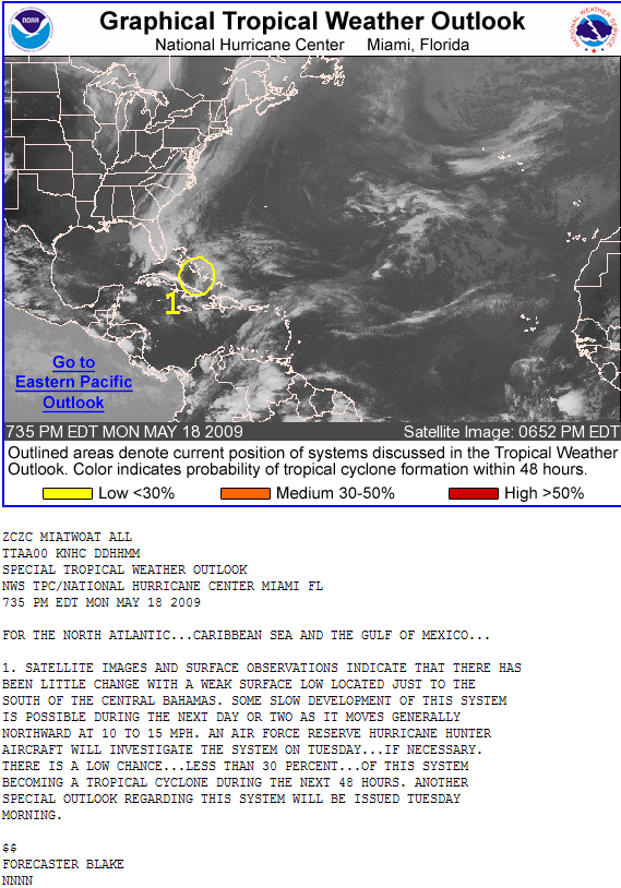
North Atlantic ... Caribbean Sea and Gulf of Mexico ( Atlantic Basin ) ...
18.05.2009 ... Florida ( Gul of Mexico ) ...
Low Potential Disturbance #1 ...
Looming Florida Storm May Gather Tropical Characteristics ...
Developing Storm Will Have Major Impacts ...
Tropical Troubles Will Hit Florida ...
A potent storm system will impact Florida in the upcoming week
and could even gain tropical characteristics ...
Heavy rain will inundate the currently drought - stricken state ...
creating flooding problems where arid conditions currently exist ...
AccuWeather meteorologists are monitoring the potential
for this storm to strengthen and gather tropical characteristics
to become the first named storm of the 2009 Atlantic Hurricane Season ...
=
Developing Storm Will Have Major Impacts ...
A major storm having some of the characteristics of a tropical storm
will bring a variety of weather impacts to the Southeast coast
and most of Florida through the much of the week ...
The center of low pressure ... currently near Cuba ...
will consolidate near South Florida by early Wednesday ...
then it will track northwestward across South and central Florida
bringing heavy rainfall and gusty winds with it ...
The system could end up in the Gulf of Mexico later in the week
and could develop further as it crawls toward the northwest ...
In addition to the heavy rainfall ... strong wind impacts will be greatest
from the east coast of Florida to Georgia and southern South Carolina ...
Offshore gales are likely with 40 mph winds
from the east and the northeast impacting coastal areas ...
Winds will raise high surf and unusually high tides
which will lead to an increased chance for coastal flooding ...
There will also be dangerous rip currents along
the entire Southeast coast through the week ...
Quelle: ( AccuWeather ) ... Meteorologist Brett Anderson ...

Werbung
Invest 90 ... Erster TC 2009 ... Atlantic Basin
-
221057Gino
- Beiträge: 2225
- Registriert: Di 1. Jan 2008, 02:49
- Geschlecht: männlich
- Wohnort: CH 6044 Udligenswil LU
- Hat sich bedankt: 2 Mal
- Danksagung erhalten: 26 Mal
- Kontaktdaten:
Invest 90 ... Erster TC 2009 ... Atlantic Basin
Zuletzt geändert von 221057Gino am Di 19. Mai 2009, 07:59, insgesamt 1-mal geändert.
Meteogram CH - Udligenswil LU
http://forecast.uoa.gr/gmap/image/index ... 2,8.400671
http://gpvjma.ccs.hpcc.jp
https://twitter.com/Gino_Lucerne_CH
https://twitter.com
So long
Gino
http://forecast.uoa.gr/gmap/image/index ... 2,8.400671
http://gpvjma.ccs.hpcc.jp
https://twitter.com/Gino_Lucerne_CH
https://twitter.com
So long
Gino
-
221057Gino
- Beiträge: 2225
- Registriert: Di 1. Jan 2008, 02:49
- Geschlecht: männlich
- Wohnort: CH 6044 Udligenswil LU
- Hat sich bedankt: 2 Mal
- Danksagung erhalten: 26 Mal
- Kontaktdaten:
Re: Invest 90 ... Erster TC 2009 ... Atlantic Basin
Hurricane Season 2009 ...
The Eastern Pacific Hurricane Season began Friday ... May 15th ...
The Atlantic Hurricane Season starts on June 1st ...
=
Tropical Tracker ...
National Hurricane Center ( NHC Models ) ...

=
Invest 90 ...

=
Invest 90 ( Current Track ) ...

=
Invest 90 ( Intensity ) ...

The Eastern Pacific Hurricane Season began Friday ... May 15th ...
The Atlantic Hurricane Season starts on June 1st ...
=
Tropical Tracker ...
National Hurricane Center ( NHC Models ) ...
=
Invest 90 ...
=
Invest 90 ( Current Track ) ...
=
Invest 90 ( Intensity ) ...
Meteogram CH - Udligenswil LU
http://forecast.uoa.gr/gmap/image/index ... 2,8.400671
http://gpvjma.ccs.hpcc.jp
https://twitter.com/Gino_Lucerne_CH
https://twitter.com
So long
Gino
http://forecast.uoa.gr/gmap/image/index ... 2,8.400671
http://gpvjma.ccs.hpcc.jp
https://twitter.com/Gino_Lucerne_CH
https://twitter.com
So long
Gino
-
Alfred

- Beiträge: 10469
- Registriert: Mo 21. Jul 2003, 16:23
- Geschlecht: männlich
- Wohnort: 8037 Zürich
- Hat sich bedankt: 49 Mal
- Danksagung erhalten: 90 Mal
Re: Invest 90 ... Erster TC 2009 ... Atlantic Basin
Ich würde Annehmen, dass das nicht viel werden wird!
(meine eigenen 1900Z +72F)
Gruss, Alfred
(meine eigenen 1900Z +72F)
Gruss, Alfred
-
221057Gino
- Beiträge: 2225
- Registriert: Di 1. Jan 2008, 02:49
- Geschlecht: männlich
- Wohnort: CH 6044 Udligenswil LU
- Hat sich bedankt: 2 Mal
- Danksagung erhalten: 26 Mal
- Kontaktdaten:
Re: Invest 90 ... Erster TC 2009 ... Atlantic Basin
Guten Morgen
@Alfred ( Salü )
Abwarten aber scheint mir auch so ... zu schwach
@Alfred ( Salü )
Abwarten aber scheint mir auch so ... zu schwach
Zuletzt geändert von 221057Gino am Di 19. Mai 2009, 15:10, insgesamt 3-mal geändert.
Meteogram CH - Udligenswil LU
http://forecast.uoa.gr/gmap/image/index ... 2,8.400671
http://gpvjma.ccs.hpcc.jp
https://twitter.com/Gino_Lucerne_CH
https://twitter.com
So long
Gino
http://forecast.uoa.gr/gmap/image/index ... 2,8.400671
http://gpvjma.ccs.hpcc.jp
https://twitter.com/Gino_Lucerne_CH
https://twitter.com
So long
Gino
-
urbi
Re: Invest 90 ... Erster TC 2009 ... Atlantic Basin
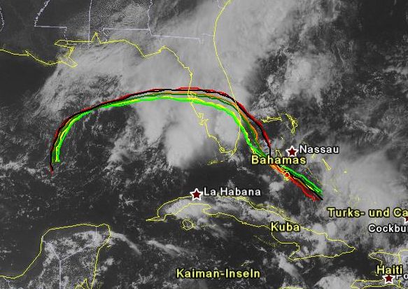
Guätä Morgä. No ä Animation.
http://www.sturmforum.ch/forum_uploads/ ... i_frei.gif
http://www.sturmforum.ch/forum_uploads/ ... i_frei.gif
-
221057Gino
- Beiträge: 2225
- Registriert: Di 1. Jan 2008, 02:49
- Geschlecht: männlich
- Wohnort: CH 6044 Udligenswil LU
- Hat sich bedankt: 2 Mal
- Danksagung erhalten: 26 Mal
- Kontaktdaten:
Re: Invest 90 ... Erster TC 2009 ... Atlantic Basin
Tag wohl ...
=
Storm Could Be a Drought Buster ...
The slow - moving storm that will track from Cuba
through South Florida over the next couple of days
will bring much needed rainfall to drought - stricken areas
of central and South Florida ...
but it may end up as too much rain in too short a time ...
Parts of central and South Florida could end up
with 4 to as much as 8 inches of rain
by the end of Thursday as the storm spreads deep ...
tropical moisture across the state ...
Obviously ... with this much rainfall there will be flooding
of poor drainage areas ...
including roads and fields through most of the week.
Quelle: AccuWeather ... Meteorologist Brett Anderson ...
=
4 Inches = 101.600 mm ...
8 Inches = 203.200 mm ...
=
Storm Could Be a Drought Buster ...
The slow - moving storm that will track from Cuba
through South Florida over the next couple of days
will bring much needed rainfall to drought - stricken areas
of central and South Florida ...
but it may end up as too much rain in too short a time ...
Parts of central and South Florida could end up
with 4 to as much as 8 inches of rain
by the end of Thursday as the storm spreads deep ...
tropical moisture across the state ...
Obviously ... with this much rainfall there will be flooding
of poor drainage areas ...
including roads and fields through most of the week.
Quelle: AccuWeather ... Meteorologist Brett Anderson ...
=
4 Inches = 101.600 mm ...
8 Inches = 203.200 mm ...
Meteogram CH - Udligenswil LU
http://forecast.uoa.gr/gmap/image/index ... 2,8.400671
http://gpvjma.ccs.hpcc.jp
https://twitter.com/Gino_Lucerne_CH
https://twitter.com
So long
Gino
http://forecast.uoa.gr/gmap/image/index ... 2,8.400671
http://gpvjma.ccs.hpcc.jp
https://twitter.com/Gino_Lucerne_CH
https://twitter.com
So long
Gino