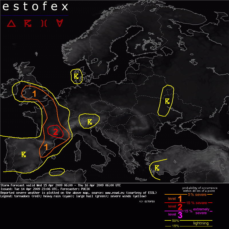
Grüsse CrosleyStorm Forecast
Valid: Wed 15 Apr 2009 06:00 to Thu 16 Apr 2009 06:00 UTC
Issued: Tue 14 Apr 2009 23:06
Forecaster: PUCIK
SYNOPSIS
A ridge of high pressure at mid and upper levels of troposphere is stretching from the Mediterranean into Central Europe. To the west a broad cyclonic vortex will influence the weather development. Its center will be located close to the Spanish NW coast with several impulses rotating around it in strong mid level flow, having windspeeds over 30 m/s. Another mid-level low of smaller scale with center over Belarus / Ukraine border will slowly move southwards on the forward flank of the ridge. Generally, eastern Europe will be placed under a large, but shallow trough. At the surface, low pressure systems will affect W and SE Europe, whereas a high will become well-established over Scandinavia. The main frontal zone will stretch across W Europe with warm front crossing southern England by Wednesday morning and cold front should slowly progress across France and Spain to the east.
DISCUSSION
... S France / NE Spain....
In the left-exit region of the mid-level jet and under one of the embedded impulses rotating around the low, an upward motion is simulated by the numerical models. At the same time, a trough will cross the region, resulting in the strenghtened flow at lower levels of troposphere, reaching up to 20 m/s at 850 hPa level. Behind the region of stratiform precipitation, ongoing surface heating should lead to the destabilization, with several hundreds J/kg of MLCAPE possible across southern France, locally up to 1000 J/kg. GFS keeps also simulating deep unstable layers, so that integrated CAPE values reach quite high values. Deep level shear will be very strong under the mid-level jet, with values well over 30 m/s. However, the strongest flow will not overlap with the region of instability very well, so that around 15 - 20 m/s of DLS is expected in the region with the best instability release. Veering wind profiles associated with the trough will lead to the increase of SREH, so that more than 200 J/kg are possible. Again however, the region of instability will not correlate very well with the enhanced SREH values.
The storms will be easily initiated with the aid of synoptic scale setup and the first storms will develop already by Wednesday mornings around the Pyrenees region. The coverage will quickly increase by noon and due to the favourable forcing, a cluster of storms ( or even MCS) is quite possible, involving well organized multicells and some brief supercells as well, due to the enhanced SREH values and moderate shear. Stronger cells will have the potential to produce isolated large hail, especially in the case if supercells manage to form. This risk will probably quickly subside after the sunset with the dimnishing instability.
In the region of southern France, belt of strong low level shear is simulated by GFS, exceeding 10 m/s ( GFS 18Z run suggests even more than 15 m/s of LLS combined with surface based instability ). Also, SREH0-1 km shows locally enhanced values over 200 J/kg, overlapping with the eastern border of the unstable airmass. With quite moist air at low levels, low LCLs are expected and therefore, tornadoes are possible, if storms can tap this strong low level shear. This threat might persist into the night hours across SE France, as GFS is simulating some boundary layer instability in the region of strong LLS there and very strong forcing.
Level 2 is issued for the region, where the best overlap of shear and instability will exist and the greatest severe weather coverage is expected.
... Central to N France....
Ahead of the advancing cold front, slightly unstable airmass is anticipated with several hundred J/kg of MLCAPE possible. DLS will be quite weak, precluding more organized storms, however, pools of higher SREH and a belt of strong LLS, exceeding 12,5 m/s suggest that some storms might briefly acquire rotation and one or two tornadoes can not be ruled out.
...England / Wales...
As the warm front will cross the region, an advection of warm and humid airmass is anticipated. Surface based heating and the synoptic scale lift will lead to the slight destabilization and thundestorms will form by 12Z. SREH in 0-1km layer ahead of the surface trough will reach more than 200 J/kg with low level shear over 10 m/s. Humid airmass will guarantee the low cloud bases. Again as in the case of the N France, deep layer shear will be very weak, only around 10 m/s and we can not expect long-lasting organised storms. However, with the aid of local boundaries, brief rotation might develop and at the moment, an isolated tornado event remains possible, so that we issue a Level 1 for this area.

Werbung
Gewitter, Stürme und Unwetter in Europa 2009 (Sammelthread)
-
crosley

- Moderator
- Beiträge: 1938
- Registriert: Fr 13. Aug 2004, 15:48
- Geschlecht: männlich
- Wohnort: 5000 Aarau
- Hat sich bedankt: 419 Mal
- Danksagung erhalten: 386 Mal
- Kontaktdaten:
 Forecast/Nowcast: Gewitter Europa 2009
Heute müssen wir nicht über den "grossen Teich" blicken um eine Moderat Risk auf der Karte zu finden. In Südfrankreich wird ein Level 2 durch http://www.estofex.org ausgegeben.
Zuletzt geändert von crosley am Mi 15. Apr 2009, 08:17, insgesamt 3-mal geändert.
-
urbi
Re: Forecast/Nowcast: Gewitter Europa 2009
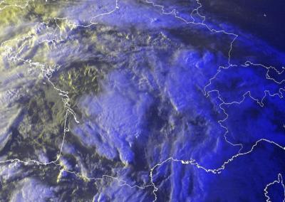
Unten noch die morgentliche Satsicht
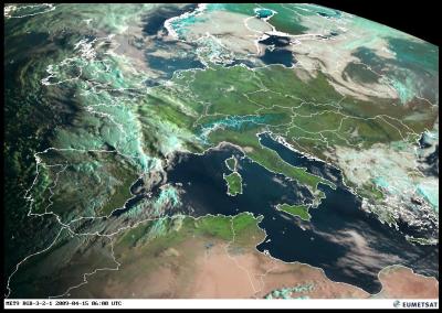

0800 Uhr MEZ
Grüss Euch
0800 Uhr MEZ

Grüss Euch
Zuletzt geändert von urbi am Mi 15. Apr 2009, 10:07, insgesamt 1-mal geändert.
-
nordspot
- Beiträge: 2332
- Registriert: So 18. Mär 2007, 16:32
- Geschlecht: männlich
- Wohnort: D-78464 Konstanz
- Hat sich bedankt: 839 Mal
- Danksagung erhalten: 298 Mal
- Kontaktdaten:
Re: Forecast/Nowcast: Gewitter Europa 2009
Tag Allerseits
Heut Morgen um kurz nach sieben Ortszeit sind wir von einem Gewitter ueberrascht worden in Farnham, Surrey, SW von London. Hab nicht schlecht gesaunt, besonders ueber die 2 House-and-castleshakers am Schluss des Gewitters. Dachte das Gasflaschendepot hats jetzt in die Luft gejagt, so hat das gebebt. Die Gewitterzellen
befinden sich (immer noch aktiv) im Moment in der Gegend von Birmingham und werden dann ueber die Irische See zur Butterinsel rueberwechseln. Bin ueber die weitere Entwicklung gespannt..
Bedeckte Gruesse aus Anglia
Ralph
Heut Morgen um kurz nach sieben Ortszeit sind wir von einem Gewitter ueberrascht worden in Farnham, Surrey, SW von London. Hab nicht schlecht gesaunt, besonders ueber die 2 House-and-castleshakers am Schluss des Gewitters. Dachte das Gasflaschendepot hats jetzt in die Luft gejagt, so hat
befinden sich (immer noch aktiv) im Moment in der Gegend von Birmingham und werden dann ueber die Irische See zur Butterinsel rueberwechseln. Bin ueber die weitere Entwicklung gespannt..
Bedeckte Gruesse aus Anglia
Ralph
nordspot Konstanz
-
crosley
- Moderator
- Beiträge: 1938
- Registriert: Fr 13. Aug 2004, 15:48
- Geschlecht: männlich
- Wohnort: 5000 Aarau
- Hat sich bedankt: 419 Mal
- Danksagung erhalten: 386 Mal
- Kontaktdaten:
Re: Forecast/Nowcast: Gewitter Europa 2009
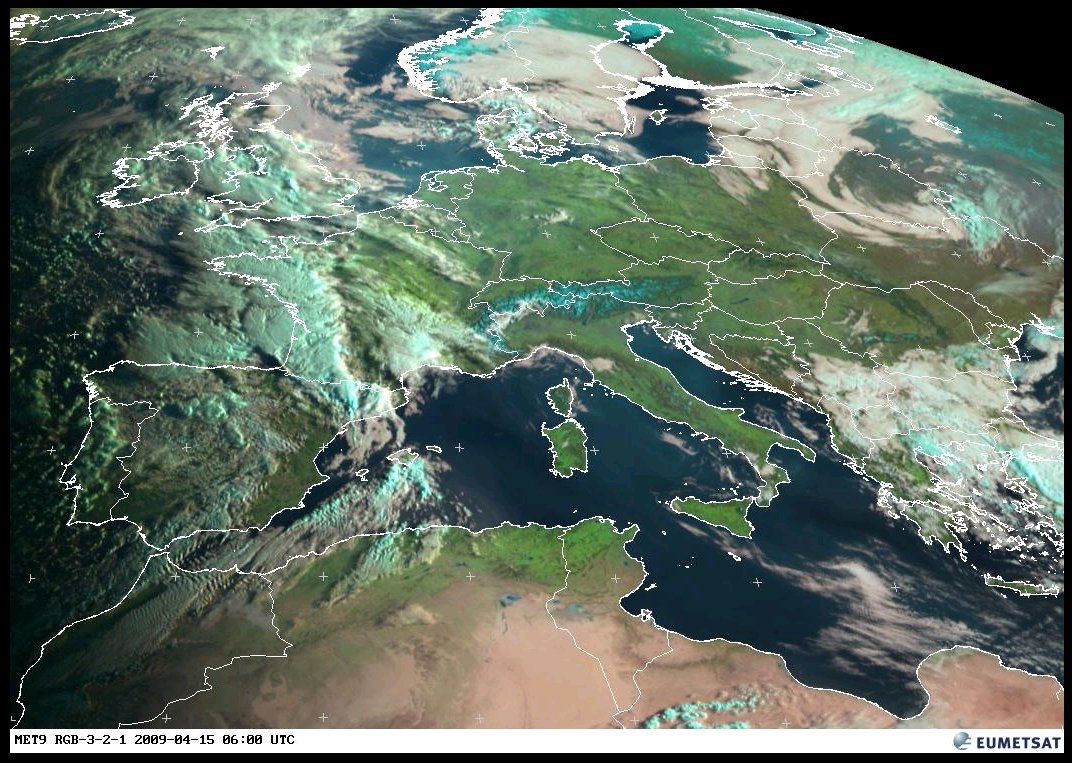
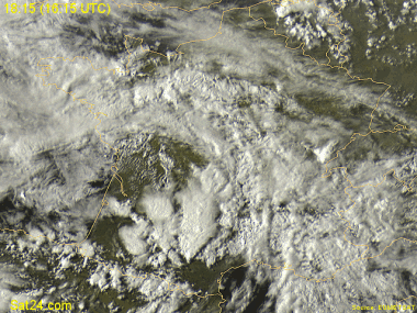
Vermutlich nun ein schöner Rightmover ganz im Süden von Frankreich.
Link zu Sat24.com: http://www.sat24.com/fr (verfällt)
Grüsse Crosley
PS: Ralph, danke für den kurzen Bericht aus GB, ich beneide Dich nicht nur wegen dem Gewitter etwas
Link zu Sat24.com: http://www.sat24.com/fr (verfällt)
Grüsse Crosley
PS: Ralph, danke für den kurzen Bericht aus GB, ich beneide Dich nicht nur wegen dem Gewitter etwas
-
urbi
Re: Forecast/Nowcast: Gewitter Europa 2009
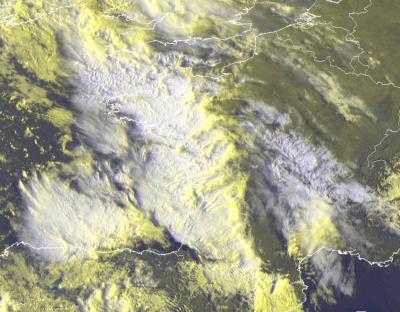
Gerade noch erwischt- 

Hier noch die Situation von 20.00 Uhr
Hier noch die Situation von 20.00 Uhr

Zuletzt geändert von urbi am Mi 15. Apr 2009, 21:32, insgesamt 2-mal geändert.
-
Badnerland

- Beiträge: 1655
- Registriert: Di 9. Mai 2006, 20:38
- Geschlecht: männlich
- Wohnort: D - 79104 Freiburg im Breisgau
- Hat sich bedankt: 291 Mal
- Danksagung erhalten: 231 Mal
Re: Forecast/Nowcast: Gewitter Europa 2009
Hey Crosley,
auf die Zelle hatte ich es auch abgesehen (verfällt nicht; EDIT: urbi war schneller und hat es sogar geschafft den interessanten Part auszuschneiden, ich nicht...)
Sehr beeindruckendes Teil, mit ein bisschen Phantasie (oder gar ohne??) sieht man auf dem Loop sogar den Inflow.
Sat24 Link ohne Werbebanner und Menus
http://www.sat24.com/image.ashx?country ... op&sat=vis
Einfach gewünschten Typ (sat=vis oder ir) und Land (de, alps, fr und so weiter) in obigen Link einsetzen und man ist die Hälfte der Ladezeit los...
Nachtrag: Jetzt gibt es auch ein Foto von der Zelle:
http://www.infoclimat.fr/multimedia/pho ... toid=76143
Gruss Benni
Zuletzt geändert von Badnerland am Mi 15. Apr 2009, 20:50, insgesamt 1-mal geändert.
-
crosley
- Moderator
- Beiträge: 1938
- Registriert: Fr 13. Aug 2004, 15:48
- Geschlecht: männlich
- Wohnort: 5000 Aarau
- Hat sich bedankt: 419 Mal
- Danksagung erhalten: 386 Mal
- Kontaktdaten:
Re: Forecast/Nowcast: Gewitter Europa 2009
Ich möchte hier nachträglich den doch eher aussergewöhnlichen Superzellen-Ausbruch in Frankreich vom 11. Mai 2009 noch festhalten.
Situationsüberblick (Rückblick) vom www.keraunos.org: http://www.keraunos.org/supercellules-d ... -orage.htm
Thread im französischen Forum zum Event (mit tollen Bilderen): http://www.forum-keraunos.org/observati ... -t1605.htm
Bild eines möglichen Tornado, aber jedenfalls eines genialen Funnels: http://www.forum-keraunos.org/annee-200 ... -t1613.htm
Diverse Bilder aus Frankreich: http://www.sudouest.com/accueil/actuali ... 20500.html
Thread im Sturmforum zum 11.05.2009: http://www.sturmforum.ch/viewtopic.php?f=2&t=6300
Grüsse Crosley
-
URBI
Re: Forecast/Nowcast: Gewitter Europa 2009
-------------------------------------
Zuletzt geändert von URBI am Mi 8. Jul 2009, 17:32, insgesamt 1-mal geändert.
-
Cyrill

- Beiträge: 2743
- Registriert: Do 27. Mär 2008, 07:01
- Geschlecht: männlich
- Wohnort: 6215 Beromünster
- Hat sich bedankt: 2087 Mal
- Danksagung erhalten: 1715 Mal
- Kontaktdaten:
Re: Forecast/Nowcast: Gewitter Europa 2009
Wecke diesen Thread also wieder etwas zum "Leben" und poste hier einen interessanten Link, den ich von einem Kollegen bekam. Ich habe damit noch keine Erfahrung, doch der eine oder andere von Euch wird sich ihn sicher auch in die Favoritenliste einfügen.
Auf der Italienkarte werden in drei Stufen (hoch / mittel / niedrig) die Wahrscheinlichkeit von Tornados eingezeichnet... mit welcher Vorlaufzeit kann ich nicht sagen.
http://www.tornadoit.org/avvisidi.htm
Gruss Cyrill
Auf der Italienkarte werden in drei Stufen (hoch / mittel / niedrig) die Wahrscheinlichkeit von Tornados eingezeichnet... mit welcher Vorlaufzeit kann ich nicht sagen.
http://www.tornadoit.org/avvisidi.htm
Gruss Cyrill
-
Severestorms
- Administrator
- Beiträge: 6651
- Registriert: Mo 20. Aug 2001, 17:21
- Geschlecht: männlich
- Wohnort: Zürich
- Hat sich bedankt: 3801 Mal
- Danksagung erhalten: 1670 Mal
- Kontaktdaten:
Re: Forecast/Nowcast: Gewitter Europa 2009
Off TopicHoi CyrillCyrill hat geschrieben:Wecke diesen Thread also wieder etwas zum "Leben" und poste hier einen interessanten Link, den ich von einem Kollegen bekam. Ich habe damit noch keine Erfahrung, doch der eine oder andere von Euch wird sich ihn sicher auch in die Favoritenliste einfügen.
Auf der Italienkarte werden in drei Stufen (hoch / mittel / niedrig) die Wahrscheinlichkeit von Tornados eingezeichnet... mit welcher Vorlaufzeit kann ich nicht sagen.
http://www.tornadoit.org/avvisidi.htm
Gruss Cyrill
Soviel ich weiss, wird die Karte aber schon lange nicht mehr aktualisiert. Bin mir aber nicht ganz sicher. Hast du letzthin mal was Aktuelles darauf gesehen?
Merci trotzdem Cyrill
Gruss Chrigi
PS: Dieser Thread soll übrigens nicht zu einem Link-Thread ausarten (dafür gibt es unzählige andere Threads, wo es passender ist => z.B. http://www.sturmforum.ch/viewtopic.php?f=2&t=1859 oder http://www.sturmforum.ch/viewtopic.php?f=2&t=219). Hier geht es um Fore- und Nowcasting von Gewittern (inkl. Begleiterscheinungen) in Europa im Jahr 2009. Das bedeutet aber nicht, dass man zu einzelnen Ereignissen nicht auch separat ein Thread eröffnen kann (ist sogar erwünscht => aber dann Titel klar bezeichnen mit Datum, Ort und Art des Events und darauf achten, dass man nicht vom Thema abweicht). Zu diesem Thema werden wir in Kürze aus aktuellem Anlass eine Sonderinfo aufschalten.
Zuletzt geändert von Severestorms am Fr 12. Jun 2009, 13:47, insgesamt 1-mal geändert.
Founder, Owner and Operator of SSWD - Engaged in Science & Research since 1997.
Follow @SturmarchivCH on Twitter to get accurate information about severe, extreme or unusual weather events in Switzerland - fast and reliable.
Follow @SturmarchivCH on Twitter to get accurate information about severe, extreme or unusual weather events in Switzerland - fast and reliable.