Seite 1 von 16
Gewitter 05.07.2012
Verfasst: Mi 4. Jul 2012, 17:32
von Phil (Dübendorf)
Morgen siehts in Sachen Gewitter nicht schlecht aus. Für Deutschland besteht ja sogar schon eine Unwetterwarnmeldung:
Entwicklung der WETTER- und GEFAHRENLAGE bis Donnerstag, 05.07.2012, 24:00 Uhr
Am Donnerstag bereits ab dem Mittag verbreitet teils kräftige Gewitter wahrscheinlich mit Starkregen, Sturmböen und kleinerem Hagel. Auch Unwetter möglich, vor allem im Süden und Westen.
Ich denke die Baslerregion wird vor allem betroffen sein. Aber wir werden sehen...

Re: Gewitter 05.07.12
Verfasst: Mi 4. Jul 2012, 17:39
von Phil (Dübendorf)
Microwave hat geschrieben:Jaja, wer's glaubt....
Grüsse - Microwave
Ja wieso?

Ist doch immerhin vom DWD!
Man kann dieses Thema auch gerne wieder löschen!
Re: Gewitter 05.07.2012
Verfasst: Mi 4. Jul 2012, 18:08
von Christian Schlieren
@Phil
Es giebt ebe chronische pestimisten in Basel die wens (nicht mal selten) Hagelt nicht zu hause sind

Das schlägt eben auf s gemüt

Gruss
Re: Gewitter 05.07.2012
Verfasst: Mi 4. Jul 2012, 22:19
von Christian Schlieren
Hoi zäme
Ich denke der morgige Tag hat grosses Unwetterpotenzial

Die Höhenwinde bleiben weiterhin schwach und kommen aus Süd durch die annäherung des Troges aus Westen wird die Atmosphäre zusäzlich labilisiert was Kräftige ortsfeste Gewitter zur folge hat die noch kräftiger ausfallen könen als die heutigen

Ich wahr heute Abend noch in der Region Wägital Sihlsee unterwegs und die kleine unscheinbare Zelle hate es ganz schön in sich innert kurzer Zeit tratten kleinere Bäche über das Ufer und grössere schwollen stark an, das hängt wohl auch damit zusammen das die Böden im moment sehr gut mit Wasser gesätigt sind!
Ich denke bis am Freitag ist mit teils starken Unwettern mit forus auf Hochwasser zu rechnen.
Was denken die Experten zur morgigen lage?
Gruss
Re: Gewitter 05.07.2012
Verfasst: Mi 4. Jul 2012, 22:32
von Dr. Funnel
Ich habe soeben in den Zeit im Bild (ZIB) Nachrichten auf ORF 2 eine originelle Formulierung für die Gewitterprognose von Morgen gehört:
"Aus Südwesten strömt feuchtwarme Luft nach Mitteleuropa. Im Alpenraum entscheidet die Luftschichtung, ob es zu Gewittern kommt oder nicht".
Also, ein bisschen präziser hätte ich es denn schon gerne!
Re: Gewitter 05.07.2012
Verfasst: Mi 4. Jul 2012, 23:25
von Federwolke
Aus Südwesten strömt feuchtwarme Luft nach Mitteleuropa. Im Alpenraum entscheidet die Luftschichtung, ob es zu Gewittern kommt oder nicht.
Wenn das mal kein Anwärter für den "Goldenen Frosch 2012" ist...

Re: Gewitter 05.07.2012
Verfasst: Do 5. Jul 2012, 02:40
von 221057Gino
hallo zusammen
Ich habe soeben in den Zeit im Bild ( ZIB ) Nachrichten auf ORF 2
eine originelle Formulierung für die Gewitterprognose von Morgen gehört
Aus Südwesten strömt feuchtwarme Luft nach Mitteleuropa. Im Alpenraum
entscheidet die Luftschichtung, ob es zu Gewittern kommt oder nicht
Also ein bisschen präziser hätte ich es denn schon gerne
siehe thread: gewitter 03.07.2012
post: 03.07.2012 14:25 h CEST
quelle: siehe loop
http://www.sturmforum.ch/viewtopic.php?p=150598#p150598
und wie es aussieht geht das noch weiter so
mindestens noch für die nächsten 110 std. ( low mina ) im nord atlantik
ausserdem auch hier noch ein bericht über diesen summer monsoon 2012 ( dschungelsommer 2012 )
http://www.wetter24.de/wetter-news/news ... ommer.html
Re: Gewitter 05.07.2012
Verfasst: Do 5. Jul 2012, 09:38
von Rontaler
Hoi zäme
Die Spitzenprofis von ESTOFEX meinen zur heutigen Lage dies:
SYNOPSIS
The west European cut-off low is centred across north-western France. A vort-max will rotate around the base of this trough today, affecting Spain and France. The associated trough axis will spread north-eastward into Germany on Friday morning, while the strong mid-level jet remains across Spain and southern France. Ahead of the trough, warm air masses continue to spread north-westwards into Central Europe. Latest soundings indicate an EML to the south-east of Germany and western Poland, but rather steep lapse rates are also present across Germany and France. Rich low-level moisture is present in the warm air advection regime.
Central Europe
The large warm air advection regime is expected to support intense thunderstorms today. Highest coverage is expected along a cold front across eastern France, the Benelux countries, and western Germany. Additionally, a more intense frontal boundary is expected to build ahead of a plume of warm air spreading north-westward into eastern Germany, where cyclogenesis is forecast.
Across eastern France, an increasing southerly flow is expected, and some training storms are forecast along the frontal boundary that slowly moves eastward into the Benelux countries and western Germany. Locally, excessive precipitation is forecast, although the low-level moisture is not exceptionally high. Additionally, moderate vertical wind shear of 15 m/s bulk shear in the afternoon may support more intense multicells capable of producing isolated large hail. The convection may grow upscale into an MCS capable of producing excessive rain during the night hours.
Further east, steep lapse rates and rich low-level moisture will be associated with high CAPE values around 1000-2000 J/kg from southern Germany and the Baltic States to the northern Balkans and Italy. Highest coverage is expected along the frontal boundary from the Baltic States to eastern and central Germany and further to north-western Italy. Additional storms will develop further south-east over the mountains and along outflow boundaries. Given the high CAPE and at least 10 m/s 0-6 km bulk shear, storms may organize, and large or very large hail is possible. Main focus of very large hail is the region from Austria to south-eastern Germany and western Poland, where 0-3 km bulk shear increases to 10 m/s along the intensifying frontal boundary. Severe wind gusts are most likely in the south-eastern parts from Poland to the northern Balkans given steepest lapse rates there. An additional threat will be excessive precipitation due to high precipitable water content and slow, back-building storms. Storms will likely go on through-out the night across eastern Germany and northern Poland as well as over the Benelux countries and central Germany given weak cyclongenesis along the frontal boundaries.
Re: Gewitter 05.07.2012
Verfasst: Do 5. Jul 2012, 09:58
von Vortex2
Sali zäme
Hier noch die Karte von Estofex:
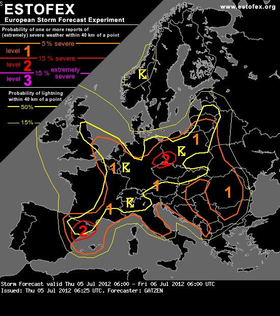
Quelle:
http://www.estofex.org
Re: Gewitter 05.07.2012
Verfasst: Do 5. Jul 2012, 10:01
von Alfred
@Damian, uns bei uns (Nordostschweiz), gibt es da auch etwas, oder müssen
wir, wie bei einer Strassenüberquerung, nach links und rechts gucken?
Grüess, Alfred