Seite 1 von 3

Tropical Storm Gonu (Arabian Sea)

Verfasst: Mo 4. Jun 2007, 18:41
von mono (Zürich)
hallo,

ist es üblich, dass sich in der arabischen see taifune/hurrikane/zyklone (wie man sie auch immer nennt in dieser gegend) bilden?

http://www.tenspider.net/weather/hurric ... n-cyclones

momentan cat5!

und hat jemand links zu forecast/warnings à la NOAA?

edit: arabische nicht persische see (bis jetzt)

- Editiert von mono (Zürich) am 04.06.2007, 22:17 -
- Editiert von mono (Zürich) am 04.06.2007, 22:18 -

Tropical Storm Gonu (Persian Sea)

Verfasst: Mo 4. Jun 2007, 18:44
von mono (Zürich)
hab selbst schon so halb was gefunden:

https://metocph.nmci.navy.mil/jtwc/warn ... 207web.txt

aber um weitere links immer dankbar.

REMARKS:
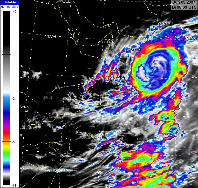
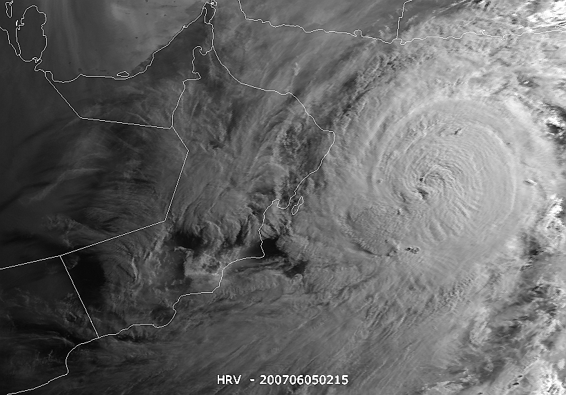
041500Z POSITION NEAR 20.1N 63.7E.
TROPICAL CYCLONE (TC) 02A (GONU), LOCATED APPROXIMATELY 380 NM
SOUTHEAST OF MUSCAT, OMAN, HAS TRACKED NORTHWESTWARD AT 10 KNOTS
OVER THE PAST 06 HOURS. TC 02A CONTINUES TO TRACK NORTHWESTWARD
ALONG THE SOUTHWESTERN PERIPHERY OF A MID-LEVEL STEERING RIDGE
ANCHORED OVER CENTRAL INDIA. THE SYSTEM WILL ENCOUNTER A SECOND
RIDGE ANCHORED OVER THE ARABIAN PENINSULA AS IT CONTINUES TO
TRACK NORTHWESTWARD THROUGH TAU 48. A WEAKNESS EXISTS BETWEEN
THE TWO RIDGES DUE TO A SERIES OF MID-LATITUDE SHORTWAVE TROUGHS
THAT CONTINUE TO TRANSIT NORTH OF THE SYSTEM. THIS WEAKNESS IS
FORECAST TO REMAIN OVER SOUTHERN IRAN AND THE STORM IS EXPECTED
TO TRACK INCREASINGLY NORTHWARD TOWARD THE COAST OF IRAN AFTER
TAU 48. THE NOGAPS AND GFDN NUMERICAL MODELS DEPICT THIS STRONG
WEAKNESS BETWEEN THE RIDGES AND INDICATE A MORE NORTHWARD TRACK
INTO THE GULF OF OMAN. EGRR, GFS, ECMWF AND AFWA MM5 DEPICT A
STRONGER RIDGE OVER SAUDI ARABIA AND THEREFORE LESS OF A TURN
NORTHWARD. THIS FORECAST IS BASED ON A CONSENSUS OF THE AVAILABLE
AIDS. THE STORM CONTINUES TO REMAIN UNDER THE AXIS OF AN UPPER
LEVEL RIDGE, KEEPING VERTICAL WIND SHEAR LOW. WESTWARD AND POLEWARD
OUTFLOW REMAINS FAVORABLE. THE STORM HAS SLIGHTLY INCREASED IN
INTENSITY OVER THE PAST SIX HOURS, BUT IS NOW BEGINNING TO SHOW
SIGNS OF WEAKENING. THE SYSTEM IS EXPECTED TO WEAKEN SLIGHTLY OVER
THE NEXT 24 HOURS AS IT MOVES OVER WATER WITH LOWER OCEAN HEAT
CONTENT, BUT MAINTAINS FAVORABLE UPPER LEVEL OUTFLOW. TC 02A IS
FORECAST TO WEAKEN MORE QUICKLY AFTER TAU 24 DUE TO THE ENTRAINMENT
OF DRY AIR FROM THE ARABIAN PENINSULA AND THEN LAND EFFECTS AFTER
LANDFALL JUST AFTER TAU 36 ALONG THE NORTHEAST COAST OF OMAN. DUE
TO LAND EFFECTS AND THE ENTRAINMENT OF DRIER AIR, TC 02A IS NOT
EXPECTED TO INTENSIFY AS IT TRACKS BACK OVER THE GULF OF OMAN BY
TAU 72. MAXIMUM SIGNIFICANT WAVE HEIGHT AT 041200Z IS 40 FEET.
NEXT WARNINGS AT 042100Z, 050300Z, 050900Z AND 051500Z.//

Tropical Storm Gonu (Persian Sea)

Verfasst: Mo 4. Jun 2007, 19:26
von mono (Zürich)
ein paar sat links ...

http://www.hurricanezone.net/#02a

Tropical Storm Gonu (Arabian Sea)

Verfasst: Mo 4. Jun 2007, 22:40
von mono (Zürich)
so wie's aussieht der erste cat4-5 in der arabischen see - von dem, was ich ersehen konnte aus http://en.wikipedia.org/wiki/List_of_No ... ne_seasons und bezugnehmend auf hardcoreweather/wunderground - kann das jemand bestätigen/widerlegen?

Tropical Storm Gonu (Arabian Sea)

Verfasst: Di 5. Jun 2007, 00:45
von mono (Zürich)

Tropical Storm Gonu (Arabian Sea)

Verfasst: Di 5. Jun 2007, 00:46
von mono (Zürich)
stratfor ein bisschen früher (english)

Category 5 Cyclone Aimed at Strait of Hormuz
June 04, 2007 18 29 GMT

A Category 5 cyclone with winds of up to 195 miles per hour is heading toward one of the world's most productive energy basins, threatening local devastation and global disruption at a point at which oil prices are already flirting with record highs. For once, the region in question is not the Gulf of Mexico. There is cause for concern; Cyclone Gonu is headed directly for the Strait of Hormuz.


The cyclone is rotating counterclockwise -- as it would in the Gulf of Mexico -- meaning that, should it enter the Persian Gulf, the gulf's west coast would suffer the most serious damage. Along the west coast, low-lying areas are the norm, and there are few barrier islands like the ones that line the Gulf of Mexico to absorb much of the storm surge that could therefore penetrate miles inland.

Like all weather phenomena, hurricanes and cyclones are notoriously fickle, so there is (thankfully) no guarantee Gonu will enter the Persian Gulf, much less wreck it. But there are two facilities that bear specific mention: the Ras Tanura and Ras al-Juaymah oil loading platforms in Saudi Arabia. So far, the chances of either of these facilities suffering a direct hit are very slim -- Gonu is still 750 miles away from those export points -- but they collectively pump nearly 10 million barrels per day (bpd) of crude. These facilities, while critical to global energy supplies and -- due to their size -- largely immune to terrorist attacks, are not particularly hurricane resistant. After all, they were built in an area where such storms are almost unheard of. Other (hardly insignificant) energy installations dot the region in Saudi Arabia, Qatar and the United Arab Emirates -- most of them on the west coast. Luckily, there is little offshore production in the Persian Gulf -- unlike in the Gulf of Mexico -- so there is unlikely to be much permanent damage to the oil production facilities themselves.

More likely is shipping disruption. Right now, Gonu is on a collision course with the Strait of Hormuz, a major chokepoint that transits some 17 million bpd of crude. Within the next few hours, the tankers and supertankers -- not to mention the massive container ships that often visit regional hubs in the United Arab Emirates -- that ply that route will be scurrying out of the storm's way. In the Gulf of Mexico, such storm-dodging is an annual ritual that is no major concern, but in the world's "Cradle of Oil," this is a completely new sport, and even a short disruption with minimal damage is sure to send the price of a barrel of crude sharply upward.

Currently the "best guess" indicates Gonu will slowly lose force to be "only" Category 3 when it makes initial landfall in Oman, forecast for June 5 at 6 p.m. local time.

Tropical Storm Gonu (Arabian Sea)

Verfasst: Di 5. Jun 2007, 09:54
von Andreas -Winterthur-
Hallo

Um Mono mal etwas abzulösen, noch ein paar Infos von heute Morgen zu diesem interessanten Typhoon:

VIS-Bild 050607_06Z:
Bild
Quelle: NRL Monterey Marine Meteorology Division

IR-Bild 050607_06Z:
Bild
Quelle: MeteoSchweiz

Das Teil macht einen ziemlich fitten Eindruck. Die äusseren Wolkenbänder erreichen eine Wolkentop Temperatur von -80°C. Gemäss
NRL Monterey Marine Meteorology Division aktuell Mittelwind 135 Kt. mit Böen 165 Kt.

Hoffentlich kommt da kein Tanker drunter oder so. Nehme an, dass wir da noch mehr hören von Gonu.

Hier noch der Forecast Track vom NLR Monterey:
Bild


Gruss Andreas

Tropical Storm Gonu (Arabian Sea)

Verfasst: Di 5. Jun 2007, 11:18
von Alfred
Sali zäme

Ich habe (speziell für die Börse ;-) ) eine etwas andere Zugbahn.
Das wäre dann am nächsten Sa./So.; Sperre der Strasse v. Hormuz.

Alfred
[hr]

Tropical Storm Gonu (Arabian Sea)

Verfasst: Di 5. Jun 2007, 11:36
von mono (Zürich)
@alfred,

"A MIDLATITUDE TROUGH OVER THE MEDITERRANEAN SEA
CONTINUES TO PROPAGATE EASTWARD AND WILL WEAKEN THE SUBTROPICAL RIDGE
NEAR TAU 24, ENHANCING THE POLEWARD TURN OF THE SYSTEM."

wird wohl draufankommen, wie stark sich dieser effekt bemerkbar macht.

http://205.85.40.22/jtwc/warnings/io0207web.txt

dürfte in jedem fall ein problem sein, sei's für öltanker (hormuz) oder frachtschiffe, die jetzt aus indien/pakistan oder den grossen arabischen häfen richtung golf von aden müssen ...

Tropical Storm Gonu (Arabian Sea)

Verfasst: Di 5. Jun 2007, 14:13
von Chrigu Riggisberg
@ Mono: Danke für diesen Monolog ;-) . Es ist cool, wenn man in diesem Forum auch über solche Dinge lesen kann. Mein Blick ist leider (allzu) oft nur auf Europa fixiert.

Hier noch ein Satellitenbild dieses tropischen Zyklons über dem nördlichen Indischen Ozean:

Bild

Quelle: http://www.eumetsat.int/Home/index.htm

Aufgrund der Animation des Satellitenbildes auf der eumetsat-Homepage würde ich vermuten, dass sich der Zyklon etwas am abschwächen ist. Kann man das überhaupt feststellen, wenn man das Satellitenbild analysiert? Ich bin überhaupt kein Experte auf diesem Gebiet. Es würde mich wie Mono ebenfalls interessieren, wie häufig derart starke Sturmsysteme in dieser Region auftreten.

Gruss Chrigu