Seite 9 von 14
Re: [FCST/NCST] Gewitter 23./24./25.07.2021
Verfasst: So 25. Jul 2021, 12:24
von Microwave
Weit müssen die Blitze ja nicht.
Das LCL ist laut dem SMN Pseudosounding auf 400 m, mindestens hier.
Grüsse - Microwave
Re: [FCST/NCST] Gewitter 23./24./25.07.2021
Verfasst: So 25. Jul 2021, 12:58
von widovnir
Tinu (Männedorf) hat geschrieben: ↑So 25. Jul 2021, 11:46
Täusche ich mich oder schert die Mittellandzelle nach rechts aus?
Die Zelle scheint weiter zu driften, aktuell werden wir hier in Wädenswil wohl nur gestreift. Aber die sichtbar grüne Färbung in Kombination mit der Kachelmann-Hagelkarte...

Nebenbei Estofex heute wieder mit einem Level 2 für die Ost-CH, sowie zusätzlich einem Level 3, welches sich hauptsächlich entlang der Grenze Deutschland-Österreich erstreckt:
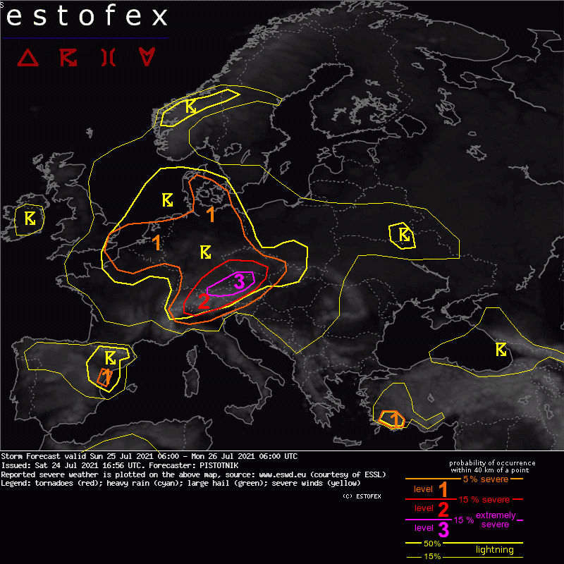
... Switzerland, SE Germany, N Austria, Czech Republic ...
The most dangerous setup develops on the northern side of the Alps. The SW-erly mid-level flow supplies persistent warm air advection. Though the initially steepest lapse rates, associated with an elevated mixed layer (EML) from NW Africa and Spain, rather graze the area to the south, the fetch of the airflow over the Alpine range is also long enough to create a secondary maximum of steep lapse rates in response to daytime heating and advect it onto rich low-level moisture in the northern forelands. Global models suggest that 500-2000 J/kg CAPE will develop over the entire area and overlap with moderate deep-layer shear (10-15 m/s) and veering wind profiles. However, as usual in this pattern, both CAPE and vertical wind shear will likely be boosted to much higher values in a 50-100 km wide belt where moist NE-erly upvalley circulations undercut the "Alpine plume" of steepened lapse rates. Consequently, high-resolution models like COSMO-D2, WRF and AROME, which can best simulate this delicate interplay, agree on an elongated corridor along the North Alpine rim where 2000-4000 J/kg CAPE are collocated with 20 m/s deep-layer shear.
A few mostly weak and elevated storms may be left over from the previous night or already form in the morning, mostly in the Czech Republic where the nose of the warm air advection regime creates synoptic lift. As daytime heating proceeds and several mid-level vorticity maxima cross the Alps, the chances for surface-based convective initiation over orographic features, along insolation gradients and various convergence zones rapidly increase around 12 UTC and afterwards.
Storms forming along the North Alpine rim are expected to quickly organize into supercells, whose right-moving tracks should allow them to perfectly follow the CAPE and shear maximum. Large to very large hail is likely with any storm that forms in this corridor, accompanied by severe downbursts and heavy rain. If one dominant supercell manages to emerge, even giant hail (8+ cm) is possible.
There are some signals that the primary storm mode could change from discrete, supercellular storms to a bowing line in the latter half of the afternoon, while the bulk of the activity advances from SE Bavaria into Upper Austria and Bohemia. In that case, the main risk would shift to scattered or widespread severe wind gusts, perhaps also including a few extreme events.
The further trajectory towards the E or NE leads the storms into still plentiful CAPE but relaxing vertical wind shear in NE Austria and Moravia. This would be a prime environment for the healthy and widespread convective activity to grow upscale into a mesoscale convective vortex that enters the Czech Republic in the evening and the first half of the night, and in fact quite a number of model forecasts shows such a scenario. While the hail and wind risks decrease, excessive precipitation becomes the main issue and may continue until midnight, before the convection finally becomes elevated and weakens.
Re: [FCST/NCST] Gewitter 23./24./25.07.2021
Verfasst: So 25. Jul 2021, 13:10
von Tinu (Männedorf)
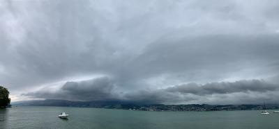
Zürichseezelle zieht südlich, Core eher Richtung Schmerikon/Linthebene. Hier am Nordrand eher schwach. Oberägeri aber mit 93 km/h-Böe.
PS: Aufzug der Zelle war aber sehr eindrücklich. War schwierig einzuschätzen, da die Zelle wegen der ohnehin vorhandenen tiefen Bewölkung lange nicht zu sehen war. Plötzlich tauchte sie dann aus dem Nichts auf, Ein "Rain Wrapped-Thunderstorm" sozusagen. Das geht auch nur in diesem Schiffsommer...
Re: [FCST/NCST] Gewitter 23./24./25.07.2021
Verfasst: So 25. Jul 2021, 13:25
von Kaiko (Döttingen)
Diese Zelle bringt viel Niederschlag. Achtung Starkregen

Radarsummen letzte 2 Stunden:
 https://meteoradar.ch/regenkarten/index.php
Gruss Kaiko
Re: [FCST/NCST] Gewitter 23./24./25.07.2021
Verfasst: So 25. Jul 2021, 13:26
von Tinu (Männedorf)
Einsiedeln mit 19,9 mm/10min. Ein ordentlicher Wert.
Hier am rechten Zürichsee ca. 4 bis 5 mm/10min. Die gestrige Zelle war intensiver.
Re: [FCST/NCST] Gewitter 23./24./25.07.2021
Verfasst: So 25. Jul 2021, 13:34
von Kaiko (Döttingen)
Hoi zäme
Die unschönen Folgen dieser Wassermassen.
Die 19.9mm in 10 Minuten und die Folgen beim Kloster Einsiedeln seht ihr im Video (Düstere Stimmung beim Kloster Einsiedeln) unter
https://www.pilatustoday.ch/zentralschw ... -142942713
Scheinbar ereignete sich bei Wolhusen ein gewaltiger Erdrutsch.

Webcambild Kloster Einsiedeln:
 https://www.kloster-einsiedeln.ch/webcam/
Gruss Kaiko
Re: [FCST/NCST] Gewitter 23./24./25.07.2021
Verfasst: So 25. Jul 2021, 13:34
von widovnir
Das Gewitter hat(te) es niederschlagstechnisch schon ziemlich in sich. Es wurden grossflächig 10-Min-Radarsummen von > 20 mm gemessen, dies entlang der gesamten Zugbahn. Als Beispiel hier, wo in der Region Root LU sogar die Stufe 40-70 mm angeknabbert wurde. Wohlgemerkt in 10 Minuten


Re: [FCST/NCST] Gewitter 23./24./25.07.2021
Verfasst: So 25. Jul 2021, 13:42
von Bernhard Oker
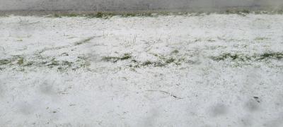
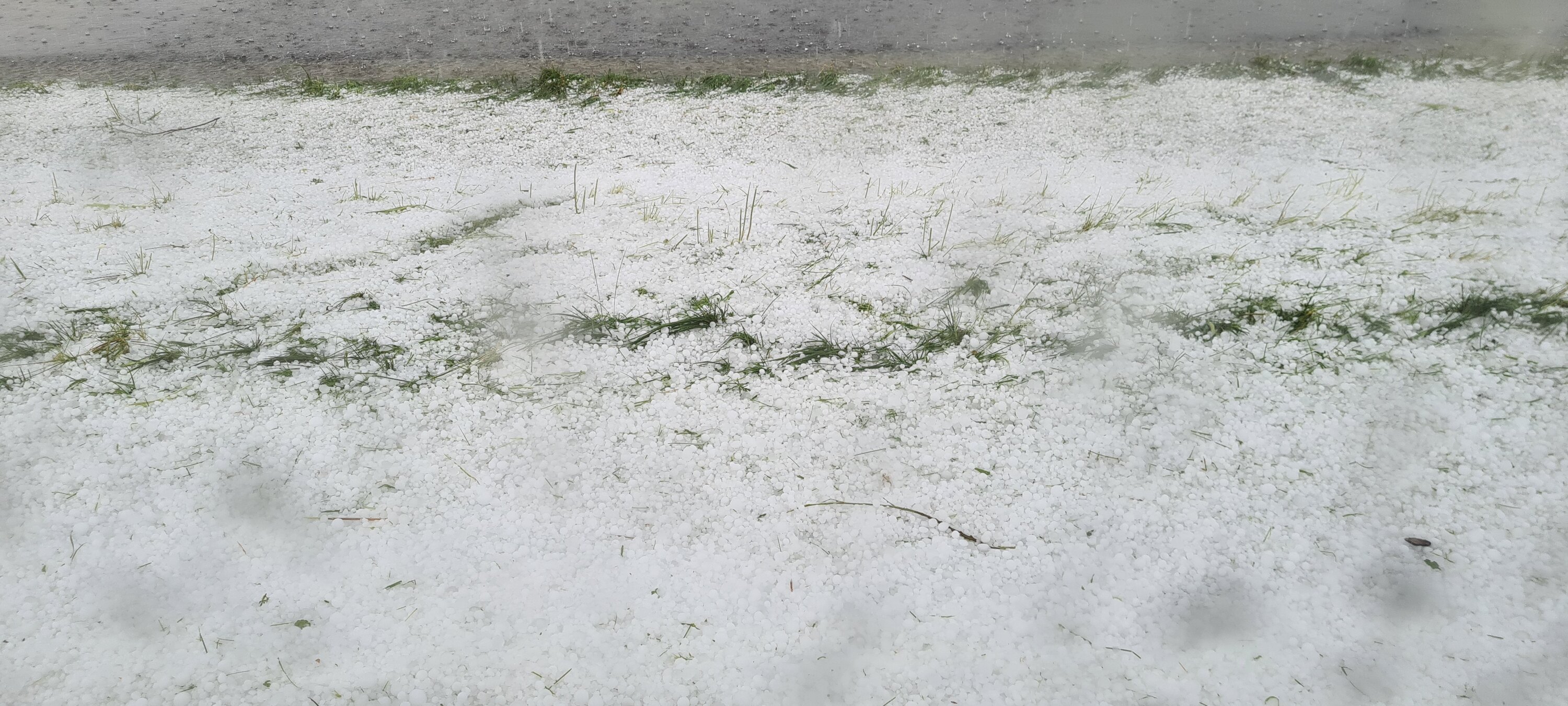
Alles zerstört

Re: [FCST/NCST] Gewitter 23./24./25.07.2021
Verfasst: So 25. Jul 2021, 13:44
von Michael (Dietikon)
Re: [FCST/NCST] Gewitter 23./24./25.07.2021
Verfasst: So 25. Jul 2021, 13:46
von Bernhard Oker
Bei Reichenburg