Mehr Infos zum bevorstehenden Extremereignis:
http://www.meteoschweiz.admin.ch/web/de ... _2011.html
oder dann auch hier:
http://www.naturgefahren.ch/

Werbung
Unwetter Südfrankreich und Alpensüdseite 03-06.11.2011
-
Michi, Uster, 455 m

- Beiträge: 2776
- Registriert: Fr 17. Aug 2001, 21:34
- Geschlecht: männlich
- Wohnort: 8610 Uster
- Danksagung erhalten: 281 Mal
-
Meteo Oberwallis

- Beiträge: 16
- Registriert: Do 3. Nov 2011, 20:33
- Geschlecht: männlich
- Wohnort: Grächen
- Kontaktdaten:
Re: FCST: Unwetter Südfrankreich und Alpensüdseite 03-06.11.
hallo Leute.
Passend zu dem unwetter habe ich die Wetterstation auf dem Simplonpass 2005 m.ü.M am letzten Wochenende in betrieb genommen. Die Wetterdaten dazu findet ihr unter : http://www.wetter-graechen.ch
gruss
Passend zu dem unwetter habe ich die Wetterstation auf dem Simplonpass 2005 m.ü.M am letzten Wochenende in betrieb genommen. Die Wetterdaten dazu findet ihr unter : http://www.wetter-graechen.ch
gruss
Private Wetterstation Grächen -> http://www.wetter-graechen.ch
Meteo Oberwallis mit 15 Wetterstationen und Webcam`s -> http://www.meteo-oberwallis.ch
Big Boss der beiden Wetterseiten
Meteo Oberwallis mit 15 Wetterstationen und Webcam`s -> http://www.meteo-oberwallis.ch
Big Boss der beiden Wetterseiten
-
Uwe/Eschlikon
- Beiträge: 3064
- Registriert: Mi 4. Jun 2003, 14:35
- Wohnort: 8360 Eschlikon/TG
- Danksagung erhalten: 334 Mal
- Kontaktdaten:
Re: FCST: Unwetter Südfrankreich und Alpensüdseite 03-06.11.
Hallo
Ob es im Wallis bis ins Hauptal so stark kommt, hängt von der genauen Anströmung (Zugbahn) und dem Süddruck zusammen. Aus SO ist für das Goms zB. gefährlicher als rein S oder gar SW. Ich hoffe jedoch, es gibt keine Wiederholung vom Oktober 2000!
Gruss, Uwe
Ob es im Wallis bis ins Hauptal so stark kommt, hängt von der genauen Anströmung (Zugbahn) und dem Süddruck zusammen. Aus SO ist für das Goms zB. gefährlicher als rein S oder gar SW. Ich hoffe jedoch, es gibt keine Wiederholung vom Oktober 2000!
Gruss, Uwe
Follow me on Instagram: https://www.instagram.com/natur_schweiz/
-
Andreas -Winterthur-

- Beiträge: 4383
- Registriert: Do 19. Jul 2012, 07:38
- Hat sich bedankt: 339 Mal
- Danksagung erhalten: 598 Mal
FCST: Unwetter Südfrankreich und Alpensüdseite 03-06.11.2011
Hello zusammen
Wir stehen hier zu dritt auf der Hotelterasse in Les Graus du roi. Versuchen im Regensturm die Blitze zu erwischen. Es herrscht hier schon wieder Weltuntergangsstimmung: übernachteten in den Cevennen: Flüsse teils schon vor Hauptlinie von heute Aben randvoll. 24 Std. bis heute Nachmittag max. 300 mm in Villefort/Dept. Lozere. Wird wohl nochmals soviel geben bis morgen. Jetzt houseshaker! Höchste Stufe rot übrigens v. Meteo France. Dazu der Sturm: wirkt hier am Meer mit den Palmen wie im Hurricane! Haben 100 kmh mit Handheld gemessen. Extreme Grüsse von Dr. F, Cyrill und mir. Wissen noch nicht wo und wie es Fr/Sa weitergeht mit unserem Trip. War ein sehr eindrücklicher severe weather Tag!
Wir stehen hier zu dritt auf der Hotelterasse in Les Graus du roi. Versuchen im Regensturm die Blitze zu erwischen. Es herrscht hier schon wieder Weltuntergangsstimmung: übernachteten in den Cevennen: Flüsse teils schon vor Hauptlinie von heute Aben randvoll. 24 Std. bis heute Nachmittag max. 300 mm in Villefort/Dept. Lozere. Wird wohl nochmals soviel geben bis morgen. Jetzt houseshaker! Höchste Stufe rot übrigens v. Meteo France. Dazu der Sturm: wirkt hier am Meer mit den Palmen wie im Hurricane! Haben 100 kmh mit Handheld gemessen. Extreme Grüsse von Dr. F, Cyrill und mir. Wissen noch nicht wo und wie es Fr/Sa weitergeht mit unserem Trip. War ein sehr eindrücklicher severe weather Tag!
“Some people are weather wise, but most are otherwise” Benjamin Franklin
-
Silas
- Beiträge: 2220
- Registriert: Di 29. Mär 2005, 19:10
- Geschlecht: männlich
- Hat sich bedankt: 11 Mal
- Danksagung erhalten: 133 Mal
- Kontaktdaten:
Re: FCST: Unwetter Südfrankreich und Alpensüdseite 03-06.11.
Hallo Andreas
Merci für euren Zwischenbericht! Die Höhenströmung dreht nun zunehmend auf Süd. Entsprechend kann das ja heiter werden: GFS 18Z macht bis Sonntag 18Z in eurer Region weitere ca. 250 mm. Auch Vigilance-Météo erwartet morgen beispielsweise auf dem Mont Aigoual (liegt im violetten Warnbereich) weitere gut 100 mm (dort heute übrigens lange Zeit Böen um 150 km/h). Andere Modelle prognostizieren in eurer Region etwas moderatere Mengen von 200 mm bis Sonntagabend (wobei schon nur der Wortstamm moderat keineswegs angebracht wäre) und simulieren die Spitzenwerte klar in Norditalien südlich des Simplons.
Gebt acht und liebe Grüsse,
Silas.
Wetterstation Oberthal 850 m.ü.M.: http://silas.emmewetter.ch
-
Christian Schlieren
- Beiträge: 3318
- Registriert: Fr 23. Jul 2004, 18:53
- Wohnort: 8952 Schlieren
- Hat sich bedankt: 505 Mal
- Danksagung erhalten: 420 Mal
Re: FCST: Unwetter Südfrankreich und Alpensüdseite 03-06.11.
Hoi zäme
Woow in Genua anscheinend bereits ein V-Shappe System und über 175mm seit Mitternacht gemäs Modellen solte es in dieser Intensität bis morgen weitergehen
Kent jemand ein gutes Radarbild für die Region Genua? und ein paar Aktuelle Niderschlagsmengen (mal abgesehen von AWEKAS)?
Gruss
Woow in Genua anscheinend bereits ein V-Shappe System und über 175mm seit Mitternacht
Kent jemand ein gutes Radarbild für die Region Genua? und ein paar Aktuelle Niderschlagsmengen (mal abgesehen von AWEKAS)?
Gruss
Zuletzt geändert von Christian Schlieren am Fr 4. Nov 2011, 06:12, insgesamt 1-mal geändert.
Christian Schlieren bei Zürich 393 M.ü.M
-
Kaiko (Döttingen)

- Moderator
- Beiträge: 2668
- Registriert: Sa 1. Sep 2001, 16:23
- Geschlecht: männlich
- Wohnort: 5312 Döttingen
- Hat sich bedankt: 2085 Mal
- Danksagung erhalten: 2135 Mal
- Kontaktdaten:
Re: FCST: Unwetter Südfrankreich und Alpensüdseite 03-06.11.
Hoi Christian
2 Radarbilder aus dem Raum Genua:
http://www.arpa.piemonte.it/upload/mete ... _compa.gif
http://meteo.meteoliguria.it/index.php? ... Itemid=227
Hitlisten auch für Italien bei Meteocentrale:
http://www.meteo-allerta.it/
Gruss Kaiko
2 Radarbilder aus dem Raum Genua:
http://www.arpa.piemonte.it/upload/mete ... _compa.gif
http://meteo.meteoliguria.it/index.php? ... Itemid=227
Hitlisten auch für Italien bei Meteocentrale:
http://www.meteo-allerta.it/
Gruss Kaiko
Mitbetreiber des Sturmarchivs Schweiz und Wetterforscher aus Leidenschaft: http://www.sturmarchiv.ch/
-
crosley

- Moderator
- Beiträge: 1938
- Registriert: Fr 13. Aug 2004, 15:48
- Geschlecht: männlich
- Wohnort: 5000 Aarau
- Hat sich bedankt: 419 Mal
- Danksagung erhalten: 386 Mal
- Kontaktdaten:
Re: FCST: Unwetter Südfrankreich und Alpensüdseite 03-06.11.
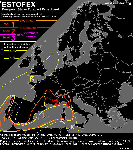
Für's Archiv...
Eine sehr ausführliche Einschätzung der Lage von Estofex ( http://www.estofex.org ):
Eine sehr ausführliche Einschätzung der Lage von Estofex ( http://www.estofex.org ):
Grüsse Crosley
Storm Forecast
Valid: Fri 04 Nov 2011 06:00 to Sat 05 Nov 2011 06:00 UTC
Issued: Thu 03 Nov 2011 20:21
Forecaster: TUSCHY
A level 2 was issued for S-France and NW-Italy mainly for excessive rainfall amounts.
A level 1 surrounds the level 2 mainly for heavy rainfall and isolated tornadoes (offshore and just inland of S-France and NW-Italy).
A level 1 was issued for NE-Spain and SW-France mainly for heavy to isolated excessive rainfall amounts.
A level 1 was issued for the Balearic Islands and surrounding areas mainly for large hail, strong wind gusts and an isolated tornado event.
A level 1 was issued for NW-Morocco and W-Portugal/far NW-Spain mainly for heavy rainfall amounts.
SYNOPSIS
A pronounced Rossby wave runs from Iceland all the way to N-Morocco and assists in a major blocking event for all of Europe. During the end of this forecast, the southern part of this high-amplitude trough starts to drip off into the far W-Mediterranean. Large-scale ridging will be the result by downstream development with gradually rising geopotential heights over central/N-Europe. Downstream of this ridge, an outbreak of cold, polar air is underway over Russia.
For the western/central Mediterranean, this day marks the start of a particular dangerous multi-days excessive rainfall event, especially for parts of SE-France and parts of NW-Italy. Please follow closely new informations and warnings of your local weather office !
DISCUSSION
... United Kingdom, far N-France and parts of the North Sea ...
Along the eastern flank of the upper trough, a mid-tropospheric wave traverses the highlighted region from SSW to NNE during the daytime hours while weakening. Despite that, a distinct thermal trough accompanies that wave with temperatures at 500 hPa dropping to below -20 °C. Some diurnal heating onshore, SSTs up to 15 °C (represented by latest buoy data) and temporarily steepening mid-level lapse rates are adequate for some widespread ~ 500 J/kg MLCAPE build-up. DLS/LL shear beneath that wave remain modest and forecast soundings in this area indicate unsuspicious conditions with mainly short, straight-line hodographs. Marginal hail and gusty winds accompany stronger storms. The overall activity remains isolated in nature. After sunset, BL becomes more stable with vanishing CAPE and incoming ridging from the SW rapidly restrains any DMC probabilities.
... W-Portugal, NW-Morocco and far SW Spain ...
Despite the recent intrusion of a modified polar air mass all the way to 20°N / 20°W, latest MIMIC-TPW data indicates both a tongue of subtropical air, which points towards SW-Spain and constant mixing of the air mass in the area mentioned above. Hence, influx of rich moisture for S-Portugal/SW-Spain is warranted until around noon, before the cold front moves in from the northwest. However, rapidly cooling mid-levels behind that front assist in widespread 500-800 J/kg MLCAPE and keep probabilities augmented for convectively induced heavy rainfall amounts. We issued a level 1 especially for the westward facing coastal areas, where heavy rainfall, marginal hail and strong wind gusts may occur. Far NW Morocco, the Strait of Gibraltar and surrounding areas may see QPF amounts up to 100 mm/24h (partly due to stratiform rain during the start of the forecast period, changing to strong showers/thunderstorms thereafter). The activity continues during the night with a gradual decrease along the W-coast of Portugal as 500 hPa heights start to increase.
... W-Mediterranean 06 Z - 15 Z ...
The overall synoptic evolution seems to be handeled well by the models as a distinct upper low gradually evolves over SW-Europe. This time-frame marks the transition period between yesterday's active phase and another one during the evening hours onwards. However disagreement still exists in the mesoscale pattern, especially where exactly any dominant convergence zone will set-up.
Focus for excessive rainfall will be SE-France (e.g. Provence-Alps-Côte D'Azur), Monaco and NW-Italy (e.g. Piemonte and Vall D'Costa). Placed between a departing upper wave to the north and the gradually consolidating upper low to the WSW, a burly SW/S-erly onshore flow continues over those areas. On the mesoscale, a N-S aligned cold front seems to slow down along the SE-coast of France and becomes quasi-stationary during that period. Clearly, this will be the focus for any training/back-building. Forecast soundings in this region show deep moisture with PWAT atop 30 mm and curved hodographs due to ongoing WAA. Current thinking is that bands of intense showers/thunderstorms keep going from 06Z onwards, producing copious amounts of rain, especially along southward facing slopes and beneath streets of training convection. 12-h rainfall amounts within the level 2 are forecast to range between 50-100 mm/12h with peaks exceeding 150 mm/12 h (as indicated by a few high resolution models). Next to that risk, LL directional shear increases along the coast/onshore, so we can't rule out a few rotating updrafts with an isolated tornado report.
Further to the south, somewhat drier/capped air mass precludes significant thunderstorm development during that period.
... W-Mediterranean 15 Z - 06 Z ...
During the afternoon hours onwards, the synoptic conditions undergo significant changes. Along the eastern flank of the upper low, conditions become very favorable for a LL depression to rapidly spin up. This occurs along a tight baroclinic boundary over E-Spain and beneath an evolving coupled jet configuration. Again, models agree fairly well in the development of a sub-1000 hPa depression over/just west of the Balearic Islands. This causes 3 different areas of interest:
a) A rapid flare-up of scattered showers and thunderstorms over the Balearic Islands and surrounding areas, as cold mid-levels move atop the 17-20°C warm SSTs. An overlap of the cyclonically curved mid/upper jet and modest CAPE create a set up favorable for well organized multicells. Heavy rainfall (locally excessive amounts possible) and isolated large hail will be the main threat. We have to monitor future model runs closely, if the LL depression evolves a bit further to the west, which would place the Balearic Islands in an environment with better LL shear (regarding an enhanced tornado risk). Despite that, we mention the risk of isolated tornadoes due to increasing LL CAPE values during the night.
b) As the LL depression forms, E/NE Spain and the Pyrenees may see an increase of widespread heavy rainfall due to a developing deformation zone. Some thunder is possible, so we included that event into our warning criterion and issued a level 1 for that.
c) Winds especially in the lowest 5 km start to respond to the deepening depression and back to southerly directions over the W-Mediterranean (east of the Balearic Islands). WAA regime with influx of very moist Mediterranean air affects all of S-France/NW-Italy during the night period with heavy to excessive rainfall amounts expected. The area around the Gulf of Lion has a good chance to see training storm activity, as SE-erly winds advect an high-ThetaE air mass towards the coast with strong convergence next to the evolving depression. Another area of concern will be the Ligurian Sea up to extreme S-Switzerland. A fetch of very moist air with impressive moisture advection runs from NW Tunisia all the way to the Ligurian coast. Best organization of training bands may await the period after 06 Z, when the LL depression starts to mature. Nevertheless, probabilities for excessive rainfall ( 50-100 mm/12 h, locally more than 150 mm/12h) are strongly enhanced with somewhat lower confidence in-between (e.g. SE France).
Please note that combining both periods, extreme NW-Italy may locally see rainfall amounts in excess of 300 mm/ 24h!
-
Andreas -Winterthur-
- Beiträge: 4383
- Registriert: Do 19. Jul 2012, 07:38
- Hat sich bedankt: 339 Mal
- Danksagung erhalten: 598 Mal
FCST: Unwetter Südfrankreich und Alpensüdseite 03-06.11.2011
Bonjour
Dank WiFi und lärmiger Baustelle vor Hotel (wie beschweren uns jetzt dann bei der Direktion, auch wegen dem schlechten Wetter...) ein Zwischenbericht aus Le Grau. Regen Summen letzte Nacht waren offenbar nicht ganz so exoripant wie teils gerechnet: 125 mm erneut in Villefort Dept. Lozere) 444 mm seit Beginn der Episode. Weitere Spitzen in den N-Cevennen in der Ardeche (Bravo EZ, wurde schon vor 4 Tagen so gerechnet). 600 mm übrigens seit Beginn am Mittwoch in Valleraugues, Dept. Gard.
Schon speziell eine so lange Episode, und wir sind mittendrin. Dazu gehören auch die Gewitter/Blitze; für mich heuer ein etwas belastenedes Thema
Vielleicht ist jdm. aufgefallen, dass es hier die ganze Nacht auslöste (wirklich praktisch vor uns); das sah auf den Blitzkarten zwar toll aus, in Realität waren die Cc's und wenigen Cg's gut im Gewölk eingepackt, das bei einer Basis von ca. knapp 100 Mt. ! Einmal chlöpfte es neben uns ( waren in der Pampa zw. Aigues- Mortes u. Saintes-Maries) und es war kein Schein zu sehen. Viel zu spät und zu Müde kapierten wir dann endlich, dass wir eigentlich nur von der Rückseite der meist genau über der Küstenlinie und sehr stationären Zellen (training cells) ins Landesinnere anbauenden Zellen, eine gute Sicht hätten. Übrigens, gab es doch einige Diskussionen ob Funnel oder Fractus .
.
Weiterer Bericht folgt (hoffe ich). PS für uns ist es übrigens schon länger auch ein Nowcast -Thread)

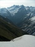
Das Tagesthema...
Tolle Aussichten:

Gruss Andreas
Dank WiFi und lärmiger Baustelle vor Hotel (wie beschweren uns jetzt dann bei der Direktion, auch wegen dem schlechten Wetter...) ein Zwischenbericht aus Le Grau. Regen Summen letzte Nacht waren offenbar nicht ganz so exoripant wie teils gerechnet: 125 mm erneut in Villefort Dept. Lozere) 444 mm seit Beginn der Episode. Weitere Spitzen in den N-Cevennen in der Ardeche (Bravo EZ, wurde schon vor 4 Tagen so gerechnet). 600 mm übrigens seit Beginn am Mittwoch in Valleraugues, Dept. Gard.
Schon speziell eine so lange Episode, und wir sind mittendrin. Dazu gehören auch die Gewitter/Blitze; für mich heuer ein etwas belastenedes Thema
Vielleicht ist jdm. aufgefallen, dass es hier die ganze Nacht auslöste (wirklich praktisch vor uns); das sah auf den Blitzkarten zwar toll aus, in Realität waren die Cc's und wenigen Cg's gut im Gewölk eingepackt, das bei einer Basis von ca. knapp 100 Mt. ! Einmal chlöpfte es neben uns ( waren in der Pampa zw. Aigues- Mortes u. Saintes-Maries) und es war kein Schein zu sehen. Viel zu spät und zu Müde kapierten wir dann endlich, dass wir eigentlich nur von der Rückseite der meist genau über der Küstenlinie und sehr stationären Zellen (training cells) ins Landesinnere anbauenden Zellen, eine gute Sicht hätten. Übrigens, gab es doch einige Diskussionen ob Funnel oder Fractus
Weiterer Bericht folgt (hoffe ich). PS für uns ist es übrigens schon länger auch ein Nowcast -Thread)
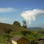
Das Tagesthema...
Tolle Aussichten:
Gruss Andreas
Zuletzt geändert von Anonymous am Fr 4. Nov 2011, 10:50, insgesamt 1-mal geändert.
“Some people are weather wise, but most are otherwise” Benjamin Franklin