Seite 2 von 11
Re: Hoch "Varnia" ab 09.12.2013
Verfasst: Sa 7. Dez 2013, 07:46
von Michi, Uster, 455 m
Willkommen zurück in den 90-Jahren! Stabile Hochs, schneearmemittleretiefe-Lagen (Früh)Winter...
Die neuesten Trends deuten darauf hin, dass das Hoch weniger sich nach Nordeuropa ausdehnt und mehr Richtung Osten. Das bedeutet kaum mehr Kaltluftbise aus Osten dafür mehr antizyklonales SW-Gesäusle...
Re: Hoch "Varnia" ab 09.12.2013
Verfasst: Sa 7. Dez 2013, 08:52
von Joachim
Hoi zäme
Mit dem angedrohten Jahrhundert-/Monsterwinter wird es so wohl auch nichts

Have a nice weekend
Joachim
Re: Hoch "Varnia" ab 09.12.2013
Verfasst: Sa 7. Dez 2013, 10:25
von Michi, Uster, 455 m
Die russische Kältepeitsche peitscht diesmal woanders hin:
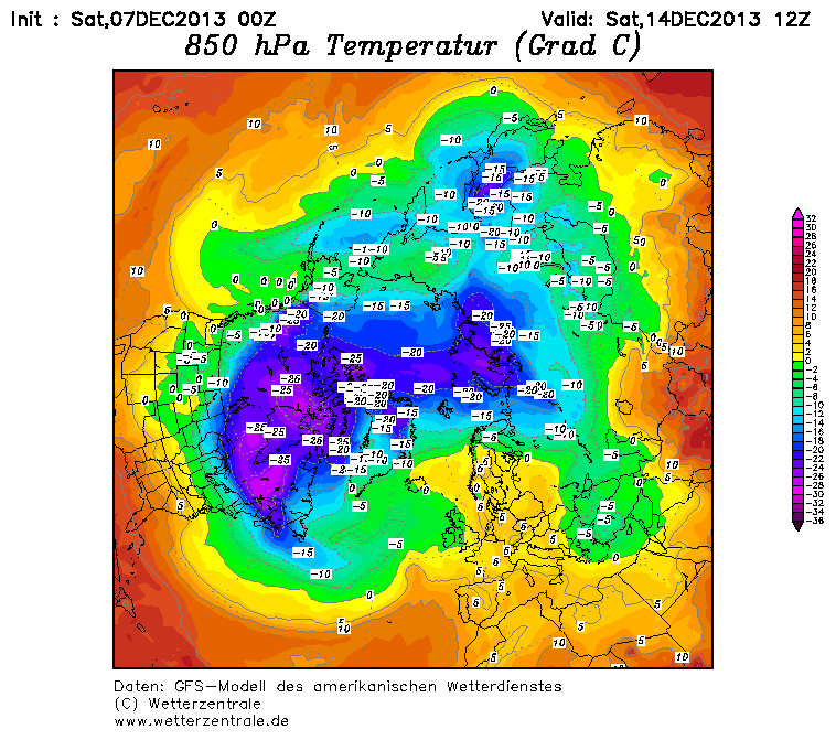
Quelle:
http://www.wetterzentrale.de/topkarten/fsavnnh.html
Re: Hoch
Verfasst: Sa 7. Dez 2013, 11:02
von Andreas -Winterthur-
Auch noch eindrücklich:

Der Keil ist aber auch nordhemisphärisch gesehen ziemlich einmalig. S. Karte von Michi oben.
PS: Hat jemand link für snowforecast (a la Bergfex mit den ZAMG Karten), aber nicht für Alpen sondern möglichst grossräumig. (Edit: gefunden -
http://www.snow-forecast.com/)
Have a nice
Gruss Andreas
Re: Hoch "Varnia" ab 09.12.2013
Verfasst: Sa 7. Dez 2013, 11:24
von Alfred
Sali zäme
Ist das eine
Russische Kältepeitsche?
Wenn ich mir
nur die 850 hPa-Temperaturanomalie vom 3. bis zum 14. Dezember anschaue, eher nicht.
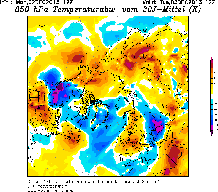
Gruss, Alfred
Analyse 2Meter Temperatur 18. & 25. November 2013 (ECMWF).
Re: Hoch "Varnia" ab 09.12.2013
Verfasst: Sa 7. Dez 2013, 13:33
von Stabe
Russische Kältepeitsche peitscht ja sowieso immer in die entgegengesetzte Richtung, sprich Ostchina.
Und dass die Amis auch alljährlich Kältewellen & Blizzards haben geht Mir auch sowas auf den Keks!
Re: Hoch "Varnia" ab 09.12.2013
Verfasst: Sa 7. Dez 2013, 13:37
von Michi, Uster, 455 m
Danke Alfred! Scheint wohl eher hausgemacht im arktischen Kanada. Aber die positive Anomalie in Sibieren ist schon noch interessant. Findet man diese auch als Archiv von früheren Jahren?
Für Sotschi scheint das wohl optimal zu sein....
Re: Hoch "Varnia" ab 09.12.2013
Verfasst: Sa 7. Dez 2013, 14:47
von Willi
Zur Gedächtnisauffrischung:
http://www.scilogs.de/klimalounge/eissc ... es-wetter/
Aber was nicht ist kann noch werden. Trotzdem beruhigend, dass es in Grönlandnähe auch mal wieder kalt (oder mind. durchschnittlich) sein kann.
Gruss Willi
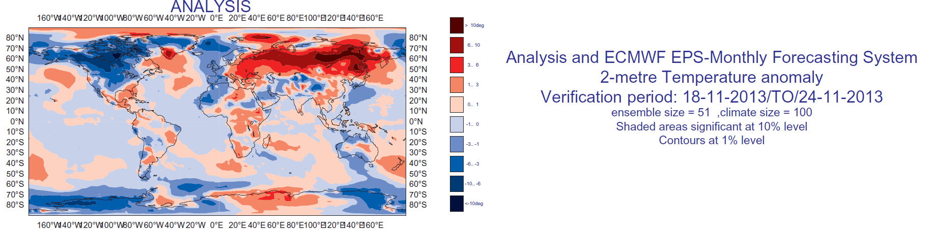
Re: Hoch "Varnia" ab 09.12.2013
Verfasst: Sa 7. Dez 2013, 14:59
von Alfred
Off Topic
Sal @Michi
ECMWF-Analyse ab dem 21. Nov. 2005 (in der Regel *) ; NAEFS, nein.
Global and regional anomaly
This graphic displays the weekly mean anomalies relative to the past 18 year climate. The top panel corresponds to the anomalies computed using ECMWF operational analysis and reanalysis for a given week. The four other panels correspond to the four monthly forecasts starting one week apart and verifying on that week. The model anomalies are relative to the model climate computed from the model back-statistics. The areas where the ensemble forecast is not significantly different from the ensemble climatology according to WMW-test are blanked (* . The time range of the forecasts is day 5-11 for the most recent forecast, day 12-18, day 19-25 and day 26-32. This figure gives an idea of how well the predicted anomalies verified against the ECMWF analysis and also about the consistency between the monthly forecasts from one week to another.
Gruss, Alfred
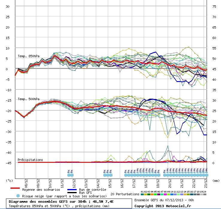
Re: Hoch "Varnia" ab 09.12.2013
Verfasst: Sa 7. Dez 2013, 16:26
von pharmazeut
wenigstens zeigt die Tendenz mittelfristig scheu in die "richtige" Richtung.
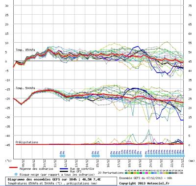
Quelle: Méteociel, Sa 7.12.13, Ensemble GEFS, 07.12.13 06h+384h