Seite 2 von 5
Re: Medicane "Rolf"
Verfasst: Di 8. Nov 2011, 09:53
von Andreas -Winterthur-
Okay, aber dies ist kein gewöhnliches Tief: deshalb plädiere ich den Namen, inkl. Thread-Titel auf "T.M.S 01M (Tropical-like Mediterranean Storm)" anzupassen.
(Zum Teil wird er nämlich auch schon als Tropischer Sturm geführt, z.B. Wetter24, was in Bezug auf Stärke und Randbedingungen meiner Meinung nach nicht passt. Ich denke es geht nur noch kurze Zeit, und dann haben wir im Blick den ersten Mittelmeer Hurricane

)
Sorry, aber in diesem Fall sollten wir uns von den Wetterpatenschafts-Namen verabschieden. Umso mehr, als das bis jetzt der Name "Rolf" noch in keinem Thread/Tweet oder sonstiger Diskussion aufgetaucht ist. Den lead sehe ich dementsprechend eher bei den Profis von NOAA.
PS: Twitter-Tweets zu
#01M
@Joachim:
Bleibt aber die Frage, wieso dieser von dir beschriebener (an und für sich synoptisch trivialer Vorgang) von den Modellen kaum erfasst wurde.
Gruss Andreas
Re: 06.-08.11.2011: Tropical-like Mediterranean Storm "01M"
Verfasst: Di 8. Nov 2011, 10:32
von Chicken3gg
Re: 06.-08.11.2011: Tropical-like Mediterranean Storm "01M"
Verfasst: Di 8. Nov 2011, 12:45
von 221057Gino
Hallo zusammen
Tropical-like Mediterranean Storm 01M
der richtige ausdruck ist TLC => Tropical Like Cyclone oder MEDICANE
===
TLC => Tropical Like Cyclone
MEDICANE => Ciclone Mediterraneo
http://www.fenomenitemporaleschi.it
http://www.fenomenitemporaleschi.it/ciclone.htm
http://streaming.ictp.trieste.it/preprints/P/98/007.pdf
http://it.wikipedia.org/wiki/Tropical-Like_Cyclone
http://www.storm2k.org/phpbb2/viewto...?f=31&t=104229
===
da dove deriva la parola MEDICANE
von wo das wort medicane stammt
MEDIterranean and hurri
CANE >>>
MEDICANE
===
Für evtl. Satbilder von TLC von frühere Zeiten im Mittelmeerraum
auf nachfraqge ... Habe einiges auf Lager
Re: 06.-08.11.2011: Tropical-like Mediterranean Storm "01M"
Verfasst: Di 8. Nov 2011, 13:01
von Joachim
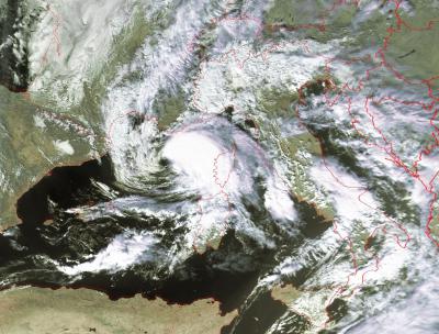
Hoi zäme
Lage um 12 UTC mit Meteosdat-Bild und EZ Böen Bodennähe (nicht alle Werte dargestellt) bis über 100 km/h:

00z EZ hat Zentrum nicht ganz richtig, wobei aber "Auge" wieder verschwunden ist.
Interessant: Im Bereich dieses tropical-like Sturms keine Gewitter!
Und in der Schweiz nochmals Föhn:
 http://www.meteocentrale.ch/de/wetter/f ... foehn.html
und bis 19 Grad zwischen Landquart und Sargans
vG
Joachim
06.-08.11.2011: Tropical-like Mediterranean Storm "01M"
Verfasst: Di 8. Nov 2011, 13:32
von Andreas -Winterthur-
Interessantes 2. Bild. Zwar kein Auge, aber das sieht wirklich tropisch aus!
Gruss Andreas
Re: 06.-08.11.2011: Tropical-like Mediterranean Storm "01M"
Verfasst: Di 8. Nov 2011, 14:39
von Andreas -Winterthur-
@ Gino:
TROPICAL-LIKE MEDITERRANEAN STORMS or Medicanes
Aus:
TROPICAL-LIKE MEDITERRANEAN STORMS: AN ANALYSIS FROM SATELLITE
Angel Luque, Lluis Fita, Romualdo Romero, Sergio Alonso
Meteorology Group, Balearic Islands University, Spain
Update von KERAUNOS:
Point du 08/11 à 11h20 loc. - Prochain point vers 15h30 loc.
En milieu de matinée ce mardi, "01M" continue de s'organiser, avec à présent la mise en place d'une convection profonde sur les 4 quadrants du système. La convection reste néanmoins surtout marquée sur la moitié est du système. L'imagerie infra-rouge laisse paraître des sommets bien froids jusqu'à -65°C. Il faut noter que 01M n'est à présent soutenue par aucune branche de jet, et devient complètement autonome, ce qui constitue l'une des caractéristiques de ce type de phénomène.
01M évolue au dessus d'une eau à 20°C environ, au large de Propriano en Corse et continue un très lent déplacement erratique.
L'imagerie radar/satellite conforte la prévision des modèles au niveau de la structure actuelle de 01M : un quadrant nord-ouest encore influencé par la présence d'air sec en altitude, et une circulation cyclonique allongée vers le nord-ouest.
Au fil de l'après-midi et ce soir, le système pourrait, d'après les dernières prévisions, parvenir à clore complètement sa circulation cyclonique et le cas échéant, former un oeil mieux structuré.
http://www.keraunos.org/tropical-like-m ... e-2011.htm
Gruss Andreas
Re: 06.-08.11.2011: Tropical-like Mediterranean Storm "01M"
Verfasst: Di 8. Nov 2011, 14:50
von Michael (Seon)
Hier :
http://onlinelibrary.wiley.com/doi/10.1 ... 1/abstract
gibt es übrigens eine Studie mit dem Titel: "The hurricane-like Mediterranean cyclone of January 1995"
Wer es gerne anschauen möchte, aber keinen Zugang kriegt kann mich anschreiben.
Grüsse, Michael
Re: 06.-08.11.2011: Tropical-like Mediterranean Storm "01M"
Verfasst: Di 8. Nov 2011, 15:05
von crosley
www.estofex.org mit einem Update:
SUMMARY: 8th NOV. 2011, 1200 UTC
-----------------------------------------------------------
LOCATION...42.1N 6.2E
ABOUT 84 NM...156 KM SE OF MARSEILLE
ABOUT 114 NM...210 KM W OF AJACCIO, CORSICA
MAXIMUM SUSTAINED WINDS...46 MPH...74 KM/H
PRESENT MOVEMENT...ROUGHLY 10KM/H TO THE EASTNORTHEAST
MINIMUM CENTRAL PRESSURE... BETWEEN 1000-1005 hPa
UPDATE 12UTC: The new update of SAB now indicates some weakening, as deep convection failed to re-develop mainly in the western part. WV imagery also indicates some dry air intrusion from higher levels, which gradually raises concern about how pronounced the warm core structure is right now. However, intense DMC evolved in the last hour or so mainly in the eastern/northern part and starts to wrap around the center. UW CIMMS also hints on somewhat augmented shear, which should remain steady during the next few hours. The cyclone now starts to increase its forward speed and moves more to the ENE to NE. This may be the result of an upper wave, which passes by to the west. Models want to stall this feature just SW of Liguria as the upper waves moves off to the north later tonight. The risk for strong downpours and gusty winds may increases over far SE France and probably along the W-Ligurian coast during the following hours.
Re: 06.-08.11.2011: Tropical-like Mediterranean Storm "01M"
Verfasst: Di 8. Nov 2011, 16:58
von Marco (Hemishofen)
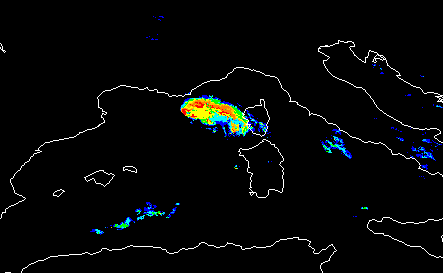
Faszinierende Zyklone, sowohl meteorologisch als auch ästhetisch, NOAA 19 (Quelle:
RS Bern):
NWC SAF PrecipitatingClouds und ConvectiveRainRate (Quelle:
www.nwcsaf.org):
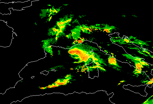
Vielleicht gibt's noch einen schönen MODIS Überflug ... Alfred wird's schon richten
Re: 06.-08.11.2011: Tropical-like Mediterranean Storm "01M"
Verfasst: Di 8. Nov 2011, 17:16
von Andreas -Winterthur-
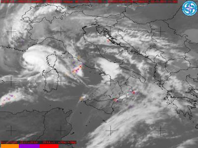
Noch was für's Auge
, der T.M.S 01M in seiner schönsten Ausprägung heute Vormittag 10 UTC:

Und als Komposit ink. Wolkentops (COSMO-7 10 Meter Wind), Blitze:
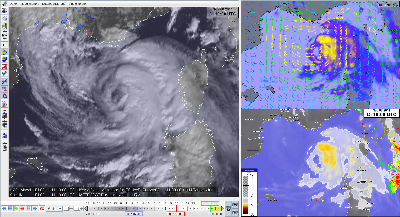
Bildquellen: MeteoSchweiz
Gruss Andreas

