Seite 2 von 4
Re: Südwestlage 05.10.2009 - 07.10.2009
Verfasst: Di 6. Okt 2009, 18:26
von Stefan im Kandertal
Badnerland: Viel zu heiss

Tinu: Nun ja 20,8°C bei derart vielen Wolken

.
Ich war und bin eher über die Temperatur hier überrascht. Natürlich kein Regen, dennoch nur 21,1°C. Und aktuell 19°C. Sonst heisst SW hier immer Mildinsel deluxe

Re: Südwestlage 05.10.2009 - 07.10.2009
Verfasst: Di 6. Okt 2009, 18:48
von Alfred
Eine Enttäuschung (Wind) hat gereicht. Heute noch trocken — das wäre zuviel gewesen!
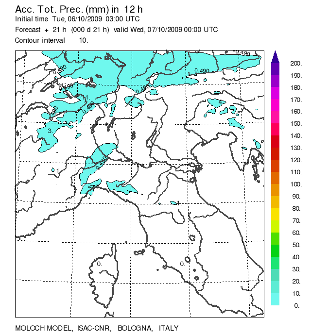 http://www.isac.cnr.it/dinamica/project ... /moloch_N/
Alfred
Re: Südwestlage 05.10.2009 - 07.10.2009
Verfasst: Mi 7. Okt 2009, 00:19
von Päsi (Wilen b. Wil)
Aktuell säuselt hier der SW-Wind und treibt die Temperaturen auf sommerliche Nachtwerte hoch: 19.8°C um Mitternacht und das Anfang Oktober! Tänikon meldet ebenfalls 19.8°C, das macht den Südthurgau zur Zeit zur wärmsten Region der CH (zumindest nach dem SMA-Netz)
Re: Südwestlage 05.10.2009 - 07.10.2009
Verfasst: Mi 7. Okt 2009, 11:04
von Badnerland
Da es fraglich ist, ob es heute im direkten Umfeld überhaupt Gewitter geben wird, mache ich dafür keinen neuen Thread auf. Wie bereits gestern geschrieben wird es vor allem nordwestlich von uns interessant, genauer gesagt über Teilen Nordfrankreichs und der Beneluxstaaten. Anbei der entsprechende Estofex Outlook:
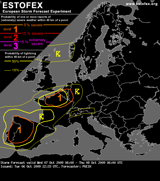
Storm Forecast
Valid: Wed 07 Oct 2009 06:00 to Thu 08 Oct 2009 06:00 UTC
Issued: Tue 06 Oct 2009 22:33
Forecaster: PUCIK
A level 1 was issued for Portugal and Western Spain mainly for tornadoes, excessive precipitation and to lesser extent severe wind gusts.
A level 1 was issued for Northwestern France and Belgium mainly for tornadoes.
SYNOPSIS
A complex scenario will evolve during the forecast period with a trough over the Eastern Atlantic and a broad cyclonic vortex over northern Europe. Around this vortex, strong mid-level jet is rotating with two jet-streaks developing embedded in it. The first one will result in a cyclogenesis over Finland and far NW Russia, namely Kola penninsula. The second jet-streak will curve around a short wave trough which will affect northern part of the British Isles during Wednesday evening and night hours. In the meantime a ridge stretching over the Central Mediterranean will move eastwards, weakening.
At the surface a very moist and warm airmass is spreading over Western and Central Europe behind the warm front, which will reach Ukraine and Belarus by Wednesday morning. Deep low pressure system will track across Central Scandinavia to Kola penninsula by the end of the forecast period with surface pressure at its center below 976 hPa. Another surface low is tied to the cold front, stretching from Northern Europe to Iberia penninsula, providing the front a wavy structure.
DISCUSSION
...
... NW France, Belgium...
Surface observations show that very humid airmass with dewpoint depressions less than 5°C has overspread the area as the surface low and associated cold front approach. A low-end instability release is expected with GFS and ECMWF expecting several hundred J/kg of MLCAPE over the region. Close to the cold front, storms are expected to initiate. This front should attain a wavy characterstic with one of the waves reaching the area with shallow surface low. This will cause backing low-level winds and enhance the SREH values. At the same time, LLS values will increase to about 10 m/s. Detrimental factor should be only weak to moderate DLS, perhaps limiting the chance of storms to become supercellular. Another questionable issue is the track of the frontal wave and a degree of instability. If storms manage to form in the region,
with moist airmass - low LCLs and enhanced shear at lower levels, tornado threat can not be ruled out and a Level 1 seems to be warranted. Copious amounts of precipitation might fall, especially to the northwest of the frontal wave, but most of it should be of stratiform nature and therefore the threat is not included in this forecast.
Quelle:
http://estofex.org/cgi-bin/polygon/show ... recast.xml
Diese Saison hatte zu genüge gezeigt, dass bei solchen Lagen damit gerechnet werden muss, dass die konvektiven Niederschläge auch schneller und weiter nach (Süd-)Osten ausgreifen können. Allerdings dürfte aufgrund der fortgeschrittenen Jahreszeit die thermische Auslöse eine untergeordnete Rolle spielen und wir müssen auf dynamische Antriebe (Kurzwellentröge in der Südwestströmung) hoffen.
Interessant wird es auch morgen, so werden recht intensive konvektive Niederschläge unmittelbar westlich der Schweiz gerechnet, wobei hier dann eher mangelnde Labilität das Problem sein dürfte. In trockenen Tüchern ist das aber sicher noch nicht. Bleibt Hoffnung auf einen späten Sommergruss in Bezug auf Gewitter, temperaturtechnisch dürfte es heute zumindest hier im Rheingraben für einen Sommertag reichen. Freiburg meldet aktuell schon 24,6 °C, und dass an einem 7. Oktober um 11 Uhr Vormittags.
Gruss Benni
Re: Südwestlage 05.10.2009 - 07.10.2009
Verfasst: Mi 7. Okt 2009, 11:11
von Thies (Wiesental)
Hallo,
und schon wieder durften wir eine phänomenale Nacht geniessen:
Freiburg hatte um 02 Uhr morgens 22,6°C am meteorolog. Institut gemessen. Auch sonst lagen die Werte durchweg über 20°C.
Aktuell sind es laue und äusserst angenehme 24,6°C, Tendenz natürlich steigend.
Gewitter erwarte ich nach dem aktuellen Stand nicht.
Gruss, Thies
Re: Südwestlage 05.10.2009 - 07.10.2009
Verfasst: Mi 7. Okt 2009, 13:37
von Michi, Uster, 455 m
Die ersten Oktoberrekorde purzeln:
La Chaux-de-Fonds 24.0 (bisher 23.1) Messbeginn 1981
Adelboden egalisiert mit 24.1 (seit 1966)
Höchstwert momentan chur mit 27.1 (für Rekord brauchts dort 29.4)
Re: Südwestlage 05.10.2009 - 07.10.2009
Verfasst: Mi 7. Okt 2009, 13:49
von Thies (Wiesental)
Freiburg, Takt. 27,3°C, Tendenz steigend
Ihringen, hier um die Ecke: 28,4°C (Quelle: Meteomedia)
Re: Südwestlage 05.10.2009 - 07.10.2009
Verfasst: Mi 7. Okt 2009, 16:17
von Thomas, Belp
Beeindruckende Temperaturen! Im Elsass (Colmar) soll sogar die Hitzemarke erreicht worden sein.
Hier kamen wir nicht mehr recht auf Touren. Es gab 24.2°C, also nicht einmal einen Sommertag.
Die maximalen Temps dürften ja jetzt erreicht sein.
Re: Südwestlage 05.10.2009 - 07.10.2009
Verfasst: Mi 7. Okt 2009, 17:01
von Badnerland
Laut Meteomedia Messnetz:
Neuenburg 30,3°C
Heitersheim & Ihringen 29,9°C
Hitzetag im Oktober, nicht gerade alltäglich
Re: Südwestlage 05.10.2009 - 07.10.2009
Verfasst: Mi 7. Okt 2009, 17:31
von Friburg
Hier Rekordtemperatur für den Oktober. Sagenhafte 26,4 Grad zeigte meine Wetterstation an!!
aktuell immer noch 24,1 Grad, obwohl die Sonne nur noch milchig durch die Wolken durchscheint.