Werbung

Gewitter 05.07.2015

Alles zu (Un)wetter relevant für die Schweiz
lukasm
Beiträge: 698
Registriert: Fr 3. Jul 2009, 17:52
Hat sich bedankt: 201 Mal
Danksagung erhalten: 124 Mal

Gewitter 05.07.2015

Beitrag von lukasm »

Hallo zusammen

Da ich nur kurz hier bin, eröffne ich den Thread für heute mit zwei drei kurzen Hinweisen.

Estofex hat heute das erste Level 3. Nichtsdestotrotz dürften heute die Gewitterchancen deutlich besser stehen als die vergangenen Tage. Cosmo-2 sieht das zwar nicht so:
Bild

Wenn es nach dem experimentellen COSMO-1 geht, dann könnte es in der Schweiz jedoch durchaus interessant werden, indem sich die Zellen in Süddeutschland deutlich weiter nach Süden ausbreitet und teilweise zumindest die Schweiz treffen könnte (Delemont/Basel). Auch vereinzelte Zellen in der Ostschweiz / Zürichseeregion und Jura scheinen demnach möglich zu sein.

Zumindest scheint die Luft in der niedrigeren Atmosphäre schon mal feuchter zu sein als die vergangenen Tage.

LG Lukas
Der Donner erschüttert die heitere Bläue des Himmels,
Weil hochfliegende Wolken im Äther einander sich stoßen,
Wenn in der Mitte sie stehn von entgegengerichteten Winden.

aus "De rerum natura", 1. Jh. v. Chr. (Titus Lucretius Carus, Lukrez)

Benutzeravatar
Tinu (Männedorf)
Beiträge: 3763
Registriert: Fr 29. Jul 2005, 16:35
Geschlecht: männlich
Wohnort: 8708 Männedorf
Hat sich bedankt: 544 Mal
Danksagung erhalten: 1343 Mal

Re: Gewitter 05.07.2015

Beitrag von Tinu (Männedorf) »

@Lukas

Ist wohl primär die Frage wann und wo es heute auslöst und nicht ob. Die gestern noch an angesprochenen Hemmnisse sind entweder bereits weg oder werden noch abgebaut. Atmosphärische Dynamik ist m.e. auch zur Genüge vorhanden, unser Trog ist eine einzige Delle...

Mein Tipp: Im Tagesverlauf Bildung von kräftigen Zellen über dem Relief. Bei genügender Intensität dann Möglichkeit von Cluster-Bildung mit hohem Unwetterpotenzial.
Tinu (Männedorf ZH, 422 m ü. M)
Gewitter und Sturm = erhöhter Pulsschlag
Föhn-fasziniert


Severestorms
Administrator
Beiträge: 6634
Registriert: Mo 20. Aug 2001, 17:21
Geschlecht: männlich
Wohnort: Zürich
Hat sich bedankt: 3717 Mal
Danksagung erhalten: 1610 Mal
Kontaktdaten:

Re: Gewitter 05.07.2015

Beitrag von Severestorms »

Fürs Archiv noch die Karte von Estofex:

Bild

Sowie den Text dazu:

Storm Forecast
Valid: Sun 05 Jul 2015 06:00 to Mon 06 Jul 2015 06:00 UTC
Issued: Sat 04 Jul 2015 23:36
Forecaster: TASZAREK

A level 3 was issued for N Germany mainly for the damaging wind gusts, large and very large hail, tornadoes and excessive precipitation.

A level 2 was issued for parts of Benelux, NE France, S Denmark, NW Poland and parts of Germany mainly for the damaging wind gusts, large and very large hail, tornadoes and excessive precipitation.

A level 1 was issued for France, Denmark, S Germany, W Poland, W Czech Republic, W Austria, parts of Italy and Switzerland mainly for the large hail, severe wind gusts and excessive precipitation. 


SYNOPSIS

A ridge with warm and moist tropical air is stretching from Morocco up to Central Europe. Extensive trough with cold front passing through W Europe is placed over N Atlantic. Another trough is placed over NW Russia and provides advection of cold air mass into NE Europe. Most of the S, SE and E Europe is covered with the weak gradient of geopotential and SLP field. The main jet streaks lie over the N France, Northern Sea, N Sweden, Finland and NW Russia. Jet with strong winds at 700 hPa extends from N France up to N Germany. Particularly severe weather is expected in the late afternoon hours over Central Europe where the good overlap of instability, wind shear, moisture and lift will take place. 

DISCUSSION

...Central Europe...

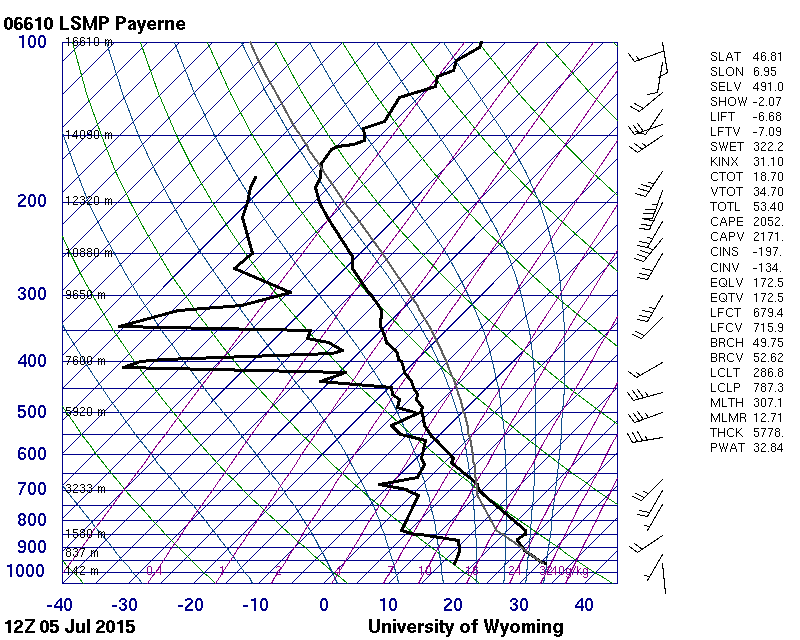
It is predicted for tomorrow that within highly unstable tropical air mass with high boundary layer's moisture content (mixing ratio: 13-14 g/kg) and elevated mixed layers from Spain (> 7 C/km) the SB CAPE values in the afternoon hours will reach up to 3000-3500 J/kg. A sharpening gradient of SW flowing mid-level geopotential will cover N France, Benelux and N Germany with DLS up to 20-25 m/s providing significant CAPExSHEAR values. A short wave trough that will provide a great source of lift is predicted by the NWP models to pass through this region in the late evening hours. Apart from that, models are also indicating a thermal low that will develop over NE France and move through Luxemburg up to N Germany will keep surface winds backed. Converging winds along the axis of the trough will provide another source of CI. Since CI within the area of the high shear and instability areas is predicted to be widespread, we issue a level 3. Strong SW flow in mid-levels with locally S and SE inflow of warm and moist air will create a SRH that may reach up to 300 m2/s2 and support the occurrence of dangerous supercellular thunderstorms. SWerly winds at 700 hPa (> 20 m/s) that will be perpendicular to the storm line create also very good conditions for the formation of QLCS that may be capable of producing damaging wind gusts.

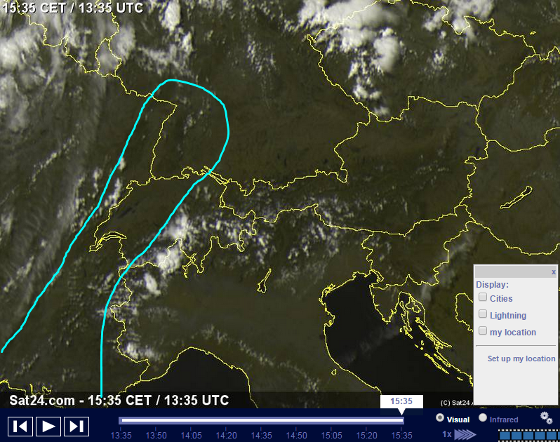
Current understanding is that CI will take place in the late afternoon hours over NE France, W Germany and Benelux within the convergence line. From the beginning, the isolated supercells may be capable of producing very large hail and tornadoes. Later on, storms due to a strong lift and shear will cluster into an organized squall line that is predicted to pass through the N Germany. It is likely that such a squall line will contain bow echos and the wind gusts within these may exceed 33 m/s. Since overlap of thermodynamic and kinematic conditions look impressive, the derecho with extreme wind gusts cannot be ruled out. In the southern flank of the storm line, convective mode may remain isolated and thus supercells producing very large hail and tornadoes in central Germany are possible. Supercells are also possible in the N Germany, Benelux and Denmark where they may occur in the front of the squall line. Tornadoes and very large hail are likely if these storms will form. Especially in the evening, when the convective mode will remain isolated and relative humidity will be increasing and thus decreasing the LCL, tornadoes threat will increase. It is difficult to predict in which direction the MCS will exactly move in the evening hours. Some of the models predict it to pass through the Denmark while some forecast that it will enter W Poland. In this forecast, two of these scenarios have been taken into account. The threat degree for the severe weather phenomena occurrence should drop in the night hours when the convection will become elevated. 

...Switzerland, W Austria, W Czech Republic, W Poland, S Germany... 

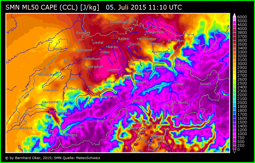
In the weakly sheared environment, no good storm organization is predicted. However, locally the high CAPE values (up to 4000 J/kg) may itself create a risk for the occurrence of the large hail and severe wind gusts within the pulse thunderstorms. Since storm motion is weak and the PW values are very large (>40mm), excessive precipitation and local flash flooding cannot be ruled out, especially in the NW Italy and S Germany. 

Quelle: Estofex.org
Founder, Owner and Operator of SSWD - Engaged in Science & Research since 1997.
Follow @SturmarchivCH on Twitter to get accurate information about severe, extreme or unusual weather events in Switzerland - fast and reliable.

Christian Schlieren
Beiträge: 3316
Registriert: Fr 23. Jul 2004, 18:53
Wohnort: 8952 Schlieren
Hat sich bedankt: 479 Mal
Danksagung erhalten: 396 Mal

Re: Gewitter 05.07.2015

Beitrag von Christian Schlieren »

Hoi zäme

Krasse CAPE werte in weiten teilen der Schweiz teil bis 5000J/kg :shock: sieht man äusserst selten bei uns :!: :help:

Ich denke heute könnte es teils Gewaltig krachen.

Bild

Quelle:http://62.202.7.134/smn_contourmap/index.aspx

Grüsse
Christian Schlieren bei Zürich 393 M.ü.M

nordspot
Beiträge: 2306
Registriert: So 18. Mär 2007, 16:32
Geschlecht: männlich
Wohnort: D-78464 Konstanz
Hat sich bedankt: 798 Mal
Danksagung erhalten: 282 Mal
Kontaktdaten:

Re: Gewitter 05.07.2015

Beitrag von nordspot »

moin.
Brisante Lage heute, je weiter nach Norden desto Peng. Ich bin mal unheimlich gespannt auf die diversen 12z Soundings aus Deutschland und der Schweiz....

Abwartende und kräftigst einheizende Grüsse

Ralph
nordspot Konstanz

Benutzeravatar
Joachim
Beiträge: 2791
Registriert: Do 16. Aug 2001, 10:53
Geschlecht: männlich
Wohnort: 8330 Pfäffikon/ZH
Hat sich bedankt: 54 Mal
Danksagung erhalten: 612 Mal
Kontaktdaten:

Re: Gewitter 05.07.2015

Beitrag von Joachim »

Hoi zäme

Auslöse zuerst bei Leukerbad ... jetzt teils heftiges Hagelgewitter im Haslital und kräftige Böen aus Norden im Oberwallis.

Lyon/FRA und Umgebung Taupunkt teils<<15°

Grüsslis

Joachim

Benutzeravatar
Willi
Administrator
Beiträge: 8876
Registriert: Fr 10. Aug 2001, 16:16
Wohnort: 8143 Sellenbüren
Hat sich bedankt: 3993 Mal
Danksagung erhalten: 3892 Mal
Kontaktdaten:

Re: Gewitter 05.07.2015

Beitrag von Willi »

Lyon/FRA und Umgebung Taupunkt teils<<15°
Die trockene Zone im Rhonetal ist im hochaufgelösten GFS Modell angedeutet, Vorhersage Taupunkt für 17h (15 UTC)
Aber 3 Stunden später alles superfeucht, teils über 20 Grad Taupunkt! Frage an die Profs: Was passiert da, und ist das realistisch?

Gruss Willi

Quelle: wetter3.de
Vorhersage 17h (15Z)
Bild

Vorhersage 20h (18Z)
Bild
Gruss Willi
Immer da wenn's wettert


Benutzeravatar
Microwave
Beiträge: 1232
Registriert: Mo 2. Aug 2010, 22:31
Geschlecht: männlich
Wohnort: 8004 Zürich
Hat sich bedankt: 2727 Mal
Danksagung erhalten: 230 Mal

Re: Gewitter 05.07.2015

Beitrag von Microwave »

Das GFS ist kaputt?

Anyways, 12Z Payerne:
Bild
(Quelle: http://weather.uwyo.edu/upperair/sounding.html, LSMP 12Z ausgewählt)

CAPE von rund 2 kJ/kg, aber auch ein beträchtlicher CINH-Wert.
DIe Trockeneinschübe können doch (manchmal) noch "die Nitro-Einspritzung bewirken", so sie nicht zu mächtig sind? (Was heisst zu mächtig?)
Weitere Interpretation: Normalhöhe des Gewitters auf rund 13 km, dann noch ein 2 km Top obendrauf - wären wir heute bei 15 km.

Grüsse - Microwave
Successful corepunches during (GA) "chasing":
11, 6, 0
5, 0

nordspot
Beiträge: 2306
Registriert: So 18. Mär 2007, 16:32
Geschlecht: männlich
Wohnort: D-78464 Konstanz
Hat sich bedankt: 798 Mal
Danksagung erhalten: 282 Mal
Kontaktdaten:

Re: Gewitter 05.07.2015

Beitrag von nordspot »

@ Willi: Bin zwar kein Profi aber wenn ich mir so das Satbild ansehe ist das mit dem Trockenlufteinschub durchaus drin, jedoch sehe ich dessen Position momentan etwas weiter östlich als geproggt:

Bild

..was im Fall längere Einstrahldauer bedeuten könnte, ein Langer Abend also?

Gespannte Grüsse

Ralph

Edit... Und ist die dünne Wolkenlinie westlich des von mir eingezeichneten Trockeneinschub nicht schon die (wenig aktive) Kaltfront :?:
Zuletzt geändert von nordspot am So 5. Jul 2015, 16:36, insgesamt 1-mal geändert.
nordspot Konstanz

Benutzeravatar
knight
Moderator
Beiträge: 1365
Registriert: Fr 29. Jul 2005, 21:58
Geschlecht: männlich
Wohnort: 1786 Sugiez
Hat sich bedankt: 981 Mal
Danksagung erhalten: 469 Mal
Kontaktdaten:

Re: Gewitter 05.07.2015

Beitrag von knight »

Über dem Neuenburgersee sieht man Niederschlagsstreifen, die nicht den Boden erreichen. Leichter Wind setzt ein.
Sugiez - Mont Vully - Seeland

Antworten