Christian Matthys hat geschrieben:Wow, die Front über Frankreich scheint wirklich heftig zu sein!

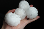
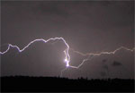
Bereits jetzt wurde grosser Hagel, ein Funnel und ein Gustnado gemeldet (Quelle: Keraunos/Infoclimat).
Ich bin nun wieder verhalten optimistisch für heute.. ein nahezu perfektes Setup, sogar Windscherung ist drin.. und alles kommt zur besten Tageszeit rein..
Ich fahre heute vermutlich an die zentralen Voralpen..

Gruss Chrigi
Hallo Chrigi
Das sind ja bisher super Nachrichten (nicht für die, die daraus Schäden verzeichnen müssen). Was heisst bei Dir "Zur besten Tageszeit" ?

Am Montag war fast nichts los in Brig, heute bin ich Arbeitsmässig in Meyrin / Vernier (Genf) und hoffe dass es besser wird als am Montag und es mal richtig krachen wird.
Soeben bei +36.2 Grad einsetzender Wind aus SW, vereinzelte Böen 20-35km/h drin. Quellungen an den Alpenkämmen gut ersichtlich, hat aber noch nicht viel davon...
@all:
Und weils gerade so schön ist: Hat schon jemand von Euch Estofex gesehen? Zwei mal Level 2, einmal Level 3 und 3mal Level 1.
Level 2 betrifft diesmal sogar die Schweiz!!

A level 3 was issued for Benelux, small area of Northern France and extreme Northwestern Germany mainly for severe wind gusts, tornadoes, excessive precipitation and large hail.
A level 2 was issued for Southern to Central France, extreme Northwestern Switzerland and Southern Germany mainly for large hail, severe wind gusts and to the lesser extent for excessive precipitation.
A level 2 was issued for Western Germany, Denmark mainly for severe wind gusts, tornadoes, excessive precipitation and to the lesser extent for large hail.
A level 1 was issued for the regions surrounding the Level 2 mainly for severe wind gusts, large hail and excessive precipitation.
A level 1 was issued for England and Wales for tornadoes.
A level 2 was issued for Finland, northern Karelian Republic and the western Kola peninsula for tornadoes, severe wind gusts and to the lesser extent for marginally large hail.
A level 1 was issued for Eastern and Northeastern Scandinavia, Northwestern Russia mainly for tornadoes and severe wind gusts.
A level 1 was issued for Slovenia, Croatia, Bosnia and Herzegovina, Ukraine, Belarus, Lithuania mainly for excessive precipitation and to the lesser extent for marginally large hail or marginally severe wind gusts.
DISCUSSION
... France, Benelux, Western half of Germany ...
***Potentially dangerous setup with severe weather outbreak is forecast over this region***
Ahead of the frontal zone, high Theta-E airmass is advected at lower levels and as cooler mid-level temperatures overspread this airmass a belt of moderate latent instability is forecast to form. Models are in fairly good agreement regarding the CAPE values, which should be mostly in the range of 1000-1500 J/kg.
With strong southerly to southwesterly flow aloft, high values of wind shear are forecast, with over 25 m/s of DLS and 20 m/s of MLS, values sufficient for very well organised convection, including supercells. With weak relative upper level flow, convection will probably tend to organise into quasi-linear system rathern than into long-lived supercells. Another factor speaking for such system is the orientation of the mid and upper level flow to the boundary, which is almost parallel and therefore, quick clustering is expected. Nevertheless, the possibility of isolated, steadier supercellular convection, especially in the earlier stages of scenario can not be discounted.
Forcing should be very favorable, in the form of the cold front and as the above mentioned short wave trough , which might induce or support cyclogenesis in the axis of the frontal trough. Such low would probably contribute to the backing of the surface winds (increasing SREH values) ahead of it and to the strenghtening wind field at lower levels. Models simulate 30 m/s 700 hPa flow during evening and night hours in the proximity and behind of the surface front.
With such strong wind field at lower levels, quickly travelling mid-level short wave trough and strong tendency for storm clustering, severe quasi-linear MCS might travel at high speeds to northeast along the front and produce a swath of severe wind gusts, including some gusts over 32 m/s. This will be the prime threat and Level 3 is issued especially for the area, where the passage of severe MCS is most probable. In the earlier stages, when isolated form of convection will prevail and over the southern parts of Level 2, large hail will be a threat, especially if supercells form. In that case, hailstones over 4 cm might be observed. Especially to the northwest of the mesoscale low, excessive precipitation might occur, at the northern end of large MCS with possibility of "train effect". With high effective PW values, at least short term excessive precipitation can not be ruled out elsewhere in Level 2. Last, but not least, tornadoes might occur and more so in the environemnt with higher SREH and LLS ahead of the mesoscale low and lower LCLs during the late evening and night hours - therefore BENELUX and Northwestern Germany will probably be the region with the highest probability of tornado occurence. The fact that the convection will tend to occur mostly in linear clusters limits the potential for tornadoes
...Eastern Germany, Northern Denmark, Alpine region...
As front progresses eastwards during the night hours, instability will diminish and become likely elevated but a slight chance for severe weather will still exist, especially as strong low level wind field will remain immediately behind the cold front.
To the south, isolated to scattered convection might form over Alpine region during the day and in moderate wind shear and instability, isolated large hail or isolated event of excessive precipitation is not ruled out.
...England, Wales...
Behind the cold front, polar maritime airmass will advect over the region with low LCLs. Diurnall heating will lead to the destabilisation and scattered showers or low topped thunderstorms are possible. In fresh westerly flow, moderate wind shear values, 15-20 m/s of DLS might sustain some well organised storms. Combined with strong shear at lower levels ( over 10 m/s of LLS) an isolated tornado can not be ruled out and a low-end Level 1 is introduced for this region.
... Eastern and Northeastern Scandinavia, Northwestern Russia...
Gruss
Dominic