Werbung

NOW 29.03.2010: Tief Kerstin

Alles zu (Un)wetter, übriges Europa und weltweit
Benutzeravatar
Cyrill
Beiträge: 2642
Registriert: Do 27. Mär 2008, 07:01
Geschlecht: männlich
Wohnort: 6215 Beromünster
Hat sich bedankt: 1888 Mal
Danksagung erhalten: 1518 Mal
Kontaktdaten:

Re: NOW 29.03.2010: Tief Kerstin

Beitrag von Cyrill »

Hoi @ Gino
War ja Zeit für's Update...
Ich habe gestern Abend wirklich überlegt loszufahren, weil ich vorallem diese Karte sah:
Bild
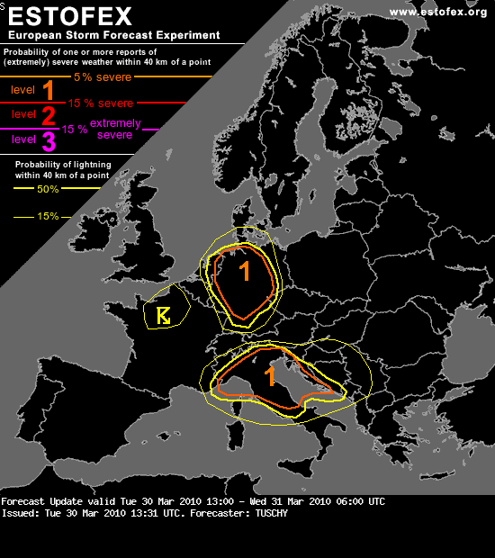
Aber auch um 18z bzw. 21z wird es an der slowenischen und kroatischen Küste in Sachen Wasserhosen / Tornados interessant.

Auf einer anderen Webseite sah ich einen relativen schwachen 300er, der zudem weiter westlich zu erkennen ist. Ein Argument zu zögern. So wunderte ich mich sehr, als Estofex schrieb:
"... North Italy towards Adriatic sea ...

Significant heights falls and quite impressive jet streak will be spreading into Alpine region, while a Lee surface low forms beneath the rather strong upper-level divergence in the left-exit jet region over NW-ern Italy during the early afternoon hours. Ahead of the system, rapid warm air advection will be spreading northwards from Adriatic sea, recovering the BL moisture with mixing ratios up to near 7-8 g/kg. Height falls and cooling mid-levels aloft will result in marginal instability release. With a developing secondary surface low, curving wind profiles from southerly to more easterly directions should be sufficient enough for formation of several low-level convergences zones across the Po valley. There, storm initiation is likely which is simulated by several models as well.

Models are predicting surface dewpoints near 10-12°C which is actually not too far away from the reality as observed values on Monday were not much different. Depends on cloud cover, instability build-up will be on going during the daytime hours. Between 500 and 800 J/kg of MLCAPE seem reasonable given the current observations. Within the jet axis, relatively strong wind shear at all levels will be present which will be supportive for organized convection once storms manage to initiate. Multicells and a few supercells will form, posing a threat for large hail and damaging winds. Despite the favorable veering winds profiles with height and quite impressive LL shear/SREH, some uncertainities are present for a tornado threat, as rather limited BL moisture limits the higher chances for tornadogenesis. Although, better LL moisture seem located toward the Po valley delta where tornadic supercells cannot be completely ruled out.

Later in the night, convection will be spreading towards the central Adriatic and western Balkans along the moving front, but instability slowly diminishes while moving more inland. With an exception of costal areas of eastern Adriatic sea, where overlaping instability and moderate shear seem maximized, no organized storms are expected."

Das norditalienische Lee-Boden-Tief ist mir schon klar und das ist eine gute Bedingung. Das sich bildende Sekundärtief und die erhebliche Warmluftadvektion aus Süden habe ich hingegen nicht gesehen. Zudem erstaunt mich diese Aussage ("the left-exit jet region over NW-ern Italy .."), weil ich den Jet woanders lokalisierte (vielleicht im falschen Lauf).
Tornadische Superzellen über der Po-Ebene werden nicht ausgeschlossen ("...located toward the Po valley delta where tornadic supercells cannot be completely ruled out."). Das Level-1-Gebiet ist schon ziemlich gross gefasst. Im Bereich Venedig gab's immer wieder Wasserhosen / Tornados. Der letzte war in Pio-X, nordöstlich von Venedig.

Gruss Cyrill

mike (reinach BL)
Beiträge: 457
Registriert: Do 9. Mär 2006, 18:15
Kontaktdaten:

Re: NOW 29.03.2010: Tief Kerstin

Beitrag von mike (reinach BL) »

Im richtigen Moment am richtig antizipierten Ort das richtige machen und das Glück provozieren führt zu solchen Blitzbildern,
auch im März. Östliches Pariserbecken. (aus infoclimat)
http://www.infoclimat.fr/multimedia/pho ... teur=&ord=

Mike


Benutzeravatar
crosley
Moderator
Beiträge: 1931
Registriert: Fr 13. Aug 2004, 15:48
Geschlecht: männlich
Wohnort: 5000 Aarau
Hat sich bedankt: 389 Mal
Danksagung erhalten: 342 Mal
Kontaktdaten:

Re: NOW 29.03.2010: Tief Kerstin

Beitrag von crosley »

In Deutschland hats nun ordentlich gezündet!

http://www.Estofex.org hat entsprechend im Vorfeld schon ein Update herausgegeben:

Bild
Forecast Update
Valid: Tue 30 Mar 2010 13:00 to Wed 31 Mar 2010 06:00 UTC
Issued: Tue 30 Mar 2010 13:31
Forecaster: TUSCHY
A level 1 was issued for Germany and parts of Netherlands mainly for isolated large hail/severe wind gusts.

A level 1 was issued for parts of Italy towards Adriatic Sea mainly for large hail, severe winds, excessive rainfall and lesser extend for tornadoes.

A level 1 was issued for Northeastern Italy and western Slovenia mainly for excessive rainfall.

SYNOPSIS

Please refer to the outlook, issued at Mon 29 Mar 2010 23:57 UTC.

DISCUSSION

... Germany and the Netherlands ...

Latest satellite data prints the strongly negative tilted trough now over north-central/southeast France with high-level PVA spreading gradually eastwards (increasing cirrus band over W-Switzerland and E-France at 13Z). Over Germany, we had good insolation with T/Tds now running at roughly 15-20°C from north to south / 5-9°C , increasing from S/W-Germany to central/north Germany. Modified soundings reveal a convective temperature, which will be hit during the upcoming 1-2h or so (also fostered by first shower development). This activity is daytime driven and especially where BL air mass is well mixed, no real support for deep/persistent updrafts is present (12Z soundings also indicate, that not much CIN is left). Nevertheless, showers and thunderstorms increase in coverage and strength during the afternoon hours (dependent on the extent of the cirrus shield and attendant diabatic heating, with regional differences in final TSTM coverage expected).

As forcing and double-front move in from the west during the late afternoon/evening hours, thunderstorm coverage will increase rapidly from west to east with a more organized appearance along the leading convergence zone/cold front. Also, some high-level divergence is in place, so thunderstorm coverage will become scattered.

No significant jet feature ejects out of France with strongest wind field mainly displaced to the cold sector/second cold front, where thermodynamics become worse. Shear is therefore marginal with multicells likely, posing an isolated large hail and strong wind gusts risk. A line-up along the cold front is probable with an MCS feature propagating from west/central Germany to the east/northeast or even due north over N-Germany, where mid-level winds back to southerly directions. One positive point could be the time of year, where a combination of still early loss of daylight, cold postfrontal air mass and a deep mixed layer (S-Germany) could increase the strength of downdrafts, which may locally increase the wind gusts risk to our severe criterion. The combined risk of isolated large hail/severe wind gusts but also the increased coverage of storms were the reason for upgrading parts of Germany to a level 1. In respect of ingredient-based forecasting, there is no real hint on an elevated tornado risk.

Thunderstorms keep going well into the night due to the forced nature, although they become more elevated in nature with a deacrease of the severe risk and coverage.

...

Grüsse Crosley

Benutzeravatar
Cyrill
Beiträge: 2642
Registriert: Do 27. Mär 2008, 07:01
Geschlecht: männlich
Wohnort: 6215 Beromünster
Hat sich bedankt: 1888 Mal
Danksagung erhalten: 1518 Mal
Kontaktdaten:

Re: NOW 29.03.2010: Tief Kerstin

Beitrag von Cyrill »

Für's Archiv und zur besseren Übersicht:

Tornado 1: am 29.03.10 gab es in der französischen Bretagne (Carentan) einen kleinen F1-Tornado. Er trat ausserhalb einer von Estofex prognostizierten Gefahrenzone auf.
http://www.keraunos.org/dossier-tornade ... france.htm

Tornado 2: am 30.03.10 gab es an der französischen Südostküste, Hyères (Le Palyvestre), einen F1-Tornado. Er trat ebenfalls nicht in der prognostizierten Gefahrenzone auf. Hingegen korrespondiert die Lokalität im weitesten Sinne mit dem left-exit-Bereich des 300er-Jets (offenbar haben weniger als 100 kt gereicht).
http://www.keraunos.org/dossier-tornade ... france.htm

Tornado 3: am 31.03.10 verwüstete ein F1-Tornado in Norditalien (Cadelbosco di Spora und Bagnolo in Piano in der Provinz Reggio Emilia) besiedeltes Gebiet.
http://www.wetter24.de/de/home/wetter/w ... uropa.html

Bild

Thread zu diesem Tornado im Sturmforum (mit eindrücklichen Fotos und Videos):
http://www.sturmforum.ch/viewtopic.php?f=12&t=6928

Gruss Cyrill
Zuletzt geändert von Cyrill am Sa 3. Apr 2010, 02:05, insgesamt 2-mal geändert.

Antworten